Property Record
13936 Kenai Spur Hwy, Kenai, AK 99611


NEARBY LISTINGS FOR SALE OR LEASE
-
-
View all Kenai listings for sale on LoopNet.com
Property Detail
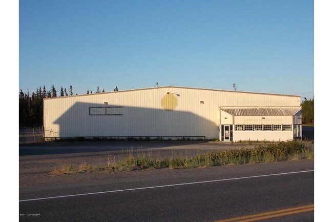
13936 Kenai Spur Hwy
039-070-17
Carl F Ahlstrom Sub
Commercialnec
T 6N R 12W SEC 25 SEWARD MERIDIAN KN 0000216 CARL F AHLSTROM SUB LOT 29 & 38 & 39 BLK 9
D
Kenai Peninsula
02122C0110E
Alaska
2024
29,38
2025
0.80 AC
000600
Alaska Regional
21,540 SF
Other Market Areas
DEMOGRAPHICS near 13936 Kenai Spur Hwy
1 Mile
3 Mile
5 Mile
2024 Total Population
1,249
5,756
10,037
2029 Population
1,388
6,408
11,129
Pop Growth 2024-2029
+ 11.13%
+ 11.33%
+ 10.88%
Average Age
36
37
38
2024 Total Households
495
2,261
3,848
HH Growth 2024-2029
+ 11.31%
+ 11.41%
+ 10.94%
Median Household Inc
$64,453
$58,279
$64,500
Avg Household Size
2.40
2.40
2.40
2024 Avg HH Vehicles
2.00
2.00
2.00
Median Home Value
$259,230
$252,486
$251,757
Median Year Built
1996
1988
1988
Nearby Places
Map Layers
Map Styles
 Street
 Aerial
- Restaurants
- Banks
- Shops
- Fitness
- Groceries
PUBLIC TRANSPORTATION
AIRPORT
Kenai Municipal
DRIVE
WALK
Distance
Kenai Municipal
11 min
3.4 mi
Freight Ports
Port of Anchorage
DRIVE
WALK
Distance
Port of Anchorage
224 min
162.8 mi
SALE & LEASE HISTORY
LISTING DATE
SALE/LEASE

Sep 25, 2016
For Lease
Oct 10, 2017
For Sale
Nearby Properties
Address
Land Use
TOTAL SIZE
Lot Size
Zoning
Address
Land Use
TOTAL SIZE
Lot Size
Zoning
67,561 SF
5 AC
Address
Land Use
TOTAL SIZE
Lot Size
Zoning
27,679 SF
279.60 AC
Address
Land Use
TOTAL SIZE
Lot Size
Zoning
62,124 SF
5.03 AC
Address
Land Use
TOTAL SIZE
Lot Size
Zoning
39,052 SF
3.61 AC
Address
Land Use
TOTAL SIZE
Lot Size
Zoning
45,567 SF
3.05 AC
Address
Land Use
TOTAL SIZE
Lot Size
Zoning
35,440 SF
20.04 AC
Address
Land Use
TOTAL SIZE
Lot Size
Zoning
25,603 SF
9.23 AC
Address
Land Use
TOTAL SIZE
Lot Size
Zoning
385 SF
45.66 AC
Address
Land Use
TOTAL SIZE
Lot Size
Zoning
48,569 SF
3.44 AC
Address
Land Use
TOTAL SIZE
Lot Size
Zoning
146,534 SF
10.70 AC
Address
Land Use
TOTAL SIZE
Lot Size
Zoning
76,625 SF
8.68 AC
Address
Land Use
TOTAL SIZE
Lot Size
Zoning
53,760 SF
4.60 AC
Address
Land Use
TOTAL SIZE
Lot Size
Zoning
160.71 AC
Address
Land Use
TOTAL SIZE
Lot Size
Zoning
29,475 SF
9.51 AC
Address
Land Use
TOTAL SIZE
Lot Size
Zoning
50,497 SF
4.64 AC
Address
Land Use
TOTAL SIZE
Lot Size
Zoning
39,357 SF
10 AC
Address
Land Use
TOTAL SIZE
Lot Size
Zoning
42,681 SF
2.15 AC
Address
Land Use
TOTAL SIZE
Lot Size
Zoning
17,571 SF
4.73 AC
Address
Land Use
TOTAL SIZE
Lot Size
Zoning
11,492 SF
9.97 AC
Address
Land Use
TOTAL SIZE
Lot Size
Zoning
24,700 SF
3.84 AC
Address
Land Use
TOTAL SIZE
Lot Size
Zoning
11,863 SF
1.62 AC
Address
Land Use
TOTAL SIZE
Lot Size
Zoning
22,972 SF
0.51 AC
Address
Land Use
TOTAL SIZE
Lot Size
Zoning
15,050 SF
5.89 AC
Address
Land Use
TOTAL SIZE
Lot Size
Zoning
29,400 SF
3.18 AC
Address
Land Use
TOTAL SIZE
Lot Size
Zoning
21,240 SF
12.78 AC
Address
Land Use
TOTAL SIZE
Lot Size
Zoning
7,420 SF
1.26 AC
Address
Land Use
TOTAL SIZE
Lot Size
Zoning
110,573 SF
14.78 AC
Address
Land Use
TOTAL SIZE
Lot Size
Zoning
5.58 AC
Address
Land Use
TOTAL SIZE
Lot Size
Zoning
21,068 SF
7.41 AC
Address
Land Use
TOTAL SIZE
Lot Size
Zoning
18,729 SF
0.97 AC
The World's #1 Commercial Real Estate Marketplace
Connect with us
© 2026 CoStar Group
The information above has been obtained from sources believed reliable. While we do not doubt its accuracy we have not verified it and make no guarantee, warranty or representation about it. It is your responsibility to independently confirm its accuracy and completeness. Any projections, opinions, assumptions, or estimates used are for example only and do not represent the current or future performance of the property. The value of this transaction to you depends on tax and other factors which should be evaluated by your tax, financial, and legal advisors. You and your advisors should conduct a careful, independent investigation of the property to determine to your satisfaction the suitability of the property for your needs.