Property Record
13939 Old Texaco Rd, Conroe, TX 77302
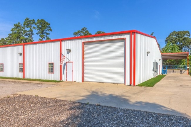


This Property Is For Sale
Property Detail
13939 Old Texaco Rd
0244-02-01500
A0244 - HOUSE RANSOM, TRACT 15, 16, ACRES 2.572
Industrialgeneral
Montgomery
1
Texas
B and X Area of moderate flood hazard, usually the area between the limits of the 100-year and 500-year floods.
1
2024
2.57 AC
2025
The Woodlands/Conroe
692202
Houston
17,400 SF
Houston-Pasadena-The Woodlands, TX
NEARBY LISTINGS FOR SALE OR LEASE
-
-
View all Conroe listings for sale on LoopNet.com
DEMOGRAPHICS near 13939 Old Texaco Rd
1 mile
3 mile
5 mile
2025 Total Population
750
7,791
49,431
2030 Population
880
9,272
59,152
Pop Growth 2025-2030
+ 17.33%
+ 19.01%
+ 19.67%
Average Age
39
38
36
2025 Total Households
243
2,670
15,968
HH Growth 2025-2030
+ 18.11%
+ 19.55%
+ 20.17%
Median Household Inc
$50,833
$73,422
$85,793
Avg Household Size
2.80
2.90
3.00
2025 Avg HH Vehicles
2.00
2.00
2.00
Median Home Value
$121,621
$186,276
$257,246
Median Year Built
1992
2003
2008
Nearby Places
Map Layers
Map Styles
 Street
 Aerial
Transit
 Traffic
 Biking
Places
Listings with unknown addresses are not visible on the map
- Restaurants
- Banks
- Shops
- Fitness
- Groceries
PUBLIC TRANSPORTATION
AIRPORT
George Bush Intcntl/Houston
Drive
Walk
Distance
George Bush Intcntl/Houston
46 min
32.1 mi
Freight Ports
Port of Houston
Drive
Walk
Distance
Port of Houston
67 min
47.3 mi
Nearby Properties
Address
Land Use
TOTAL SIZE
Lot Size
Zoning
Address
Land Use
TOTAL SIZE
Lot Size
Zoning
305,900 SF
60.85 AC
1
Address
Land Use
TOTAL SIZE
Lot Size
Zoning
205,948 SF
23.14 AC
Address
Land Use
TOTAL SIZE
Lot Size
Zoning
149,817 SF
2 AC
1
Address
Land Use
TOTAL SIZE
Lot Size
Zoning
61,000 SF
16.10 AC
1
Address
Land Use
TOTAL SIZE
Lot Size
Zoning
80,948 SF
15 AC
Address
Land Use
TOTAL SIZE
Lot Size
Zoning
23,912 SF
53.69 AC
1
Address
Land Use
TOTAL SIZE
Lot Size
Zoning
32,009 SF
13.32 AC
1
Address
Land Use
TOTAL SIZE
Lot Size
Zoning
38,020 SF
28.47 AC
1
Address
Land Use
TOTAL SIZE
Lot Size
Zoning
6,286 SF
21.84 AC
Address
Land Use
TOTAL SIZE
Lot Size
Zoning
16,996 SF
6.50 AC
1
Address
Land Use
TOTAL SIZE
Lot Size
Zoning
9,582 SF
10.46 AC
1
Address
Land Use
TOTAL SIZE
Lot Size
Zoning
8,450 SF
2.16 AC
Address
Land Use
TOTAL SIZE
Lot Size
Zoning
20,091 SF
12.04 AC
1
Address
Land Use
TOTAL SIZE
Lot Size
Zoning
32,341 SF
4.64 AC
1
Address
Land Use
TOTAL SIZE
Lot Size
Zoning
41,456 SF
5.99 AC
1
Address
Land Use
TOTAL SIZE
Lot Size
Zoning
8.87 AC
1
Address
Land Use
TOTAL SIZE
Lot Size
Zoning
8,000 SF
2.91 AC
1
Address
Land Use
TOTAL SIZE
Lot Size
Zoning
200 SF
30.60 AC
1
Address
Land Use
TOTAL SIZE
Lot Size
Zoning
14,992 SF
2.27 AC
1
Address
Land Use
TOTAL SIZE
Lot Size
Zoning
25,050 SF
9.70 AC
1
Address
Land Use
TOTAL SIZE
Lot Size
Zoning
20,984 SF
4.68 AC
1
Address
Land Use
TOTAL SIZE
Lot Size
Zoning
26,310 SF
6.50 AC
1
Address
Land Use
TOTAL SIZE
Lot Size
Zoning
25,364 SF
6.11 AC
1
Address
Land Use
TOTAL SIZE
Lot Size
Zoning
22,740 SF
5.78 AC
1
Address
Land Use
TOTAL SIZE
Lot Size
Zoning
23,880 SF
2.30 AC
1
Address
Land Use
TOTAL SIZE
Lot Size
Zoning
16,701 SF
3.06 AC
1
Address
Land Use
TOTAL SIZE
Lot Size
Zoning
10,440 SF
7.01 AC
1
Address
Land Use
TOTAL SIZE
Lot Size
Zoning
15,471 SF
4.28 AC
1
Address
Land Use
TOTAL SIZE
Lot Size
Zoning
11,890 SF
11.67 AC
1
Address
Land Use
TOTAL SIZE
Lot Size
Zoning
9,000 SF
35.22 AC
1
The World's #1 Commercial Real Estate Marketplace
Connect with us
© 2026 CoStar Group
The information above has been obtained from sources believed reliable. While we do not doubt its accuracy we have not verified it and make no guarantee, warranty or representation about it. It is your responsibility to independently confirm its accuracy and completeness. Any projections, opinions, assumptions, or estimates used are for example only and do not represent the current or future performance of the property. The value of this transaction to you depends on tax and other factors which should be evaluated by your tax, financial, and legal advisors. You and your advisors should conduct a careful, independent investigation of the property to determine to your satisfaction the suitability of the property for your needs.