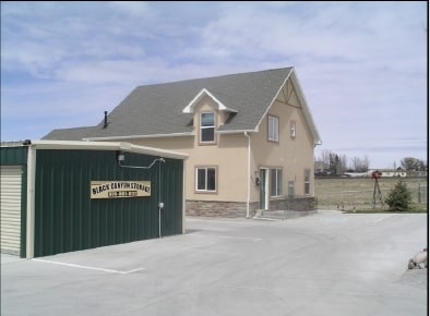
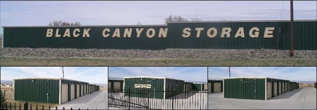
Property Record
13945 6700 Rd, Montrose, CO 81401


Property Detail
13945 6700 Rd
R0005648
S: 23 T: 49 R: 9 A TRACT OF LAND IN THE E2SE4SE4 SEC 23 DESC AS BEG AT SE COR SEC 23; TH NORTH 167.62 FT; TH N89'19'00"W 20
Publicstorage
Montrose
B and X Area of moderate flood hazard, usually the area between the limits of the 100-year and 500-year floods.
Colorado
2024
1 AC
2024
Colorado Southwest Area
966503
Other Market Areas
4,200 SF
Montrose, CO
NEARBY LISTINGS FOR SALE OR LEASE
-
-
View all Montrose listings for sale on LoopNet.com
DEMOGRAPHICS near 13945 6700 Rd
1 mile
3 mile
5 mile
2024 Total Population
1,782
21,477
30,275
2029 Population
1,856
22,447
31,716
Pop Growth 2024-2029
+ 4.15%
+ 4.52%
+ 4.76%
Average Age
46
44
43
2024 Total Households
744
9,265
12,683
HH Growth 2024-2029
+ 4.17%
+ 4.55%
+ 4.77%
Median Household Inc
$83,115
$69,151
$70,059
Avg Household Size
2.40
2.30
2.30
2024 Avg HH Vehicles
2.00
2.00
2.00
Median Home Value
$409,615
$363,120
$371,051
Median Year Built
2000
1991
1993
Nearby Places
Map Layers
Map Styles
 Street
 Aerial
Transit
 Traffic
 Biking
Places
Listings with unknown addresses are not visible on the map
- Restaurants
- Banks
- Shops
- Fitness
- Groceries
PUBLIC TRANSPORTATION
AIRPORT
Montrose Regional
Drive
Walk
Distance
Montrose Regional
15 min
6.0 mi
Freight Ports
Port of San Diego
Drive
Walk
Distance
Port of San Diego
954 min
899.9 mi
Nearby Properties
Address
Land Use
TOTAL SIZE
Lot Size
Zoning
Address
Land Use
TOTAL SIZE
Lot Size
Zoning
229,488 SF
Address
Land Use
TOTAL SIZE
Lot Size
Zoning
104,240 SF
29.39 AC
Address
Land Use
TOTAL SIZE
Lot Size
Zoning
84,927 SF
15.45 AC
Address
Land Use
TOTAL SIZE
Lot Size
Zoning
49,158 SF
18.15 AC
Address
Land Use
TOTAL SIZE
Lot Size
Zoning
93,240 SF
8.32 AC
Address
Land Use
TOTAL SIZE
Lot Size
Zoning
17,872 SF
2 AC
Address
Land Use
TOTAL SIZE
Lot Size
Zoning
52,533 SF
3.73 AC
Address
Land Use
TOTAL SIZE
Lot Size
Zoning
63,757 SF
2.14 AC
Address
Land Use
TOTAL SIZE
Lot Size
Zoning
54,088 SF
79.70 AC
Address
Land Use
TOTAL SIZE
Lot Size
Zoning
9,607 SF
17.78 AC
Address
Land Use
TOTAL SIZE
Lot Size
Zoning
48,096 SF
33.43 AC
B2
Address
Land Use
TOTAL SIZE
Lot Size
Zoning
68,768 SF
7.73 AC
Address
Land Use
TOTAL SIZE
Lot Size
Zoning
33,554 SF
10 AC
Address
Land Use
TOTAL SIZE
Lot Size
Zoning
51,727 SF
2.56 AC
Address
Land Use
TOTAL SIZE
Lot Size
Zoning
38,729 SF
3.83 AC
Address
Land Use
TOTAL SIZE
Lot Size
Zoning
13,091 SF
0.86 AC
MR
Address
Land Use
TOTAL SIZE
Lot Size
Zoning
250,620 SF
21.70 AC
Address
Land Use
TOTAL SIZE
Lot Size
Zoning
34,032 SF
1.56 AC
Address
Land Use
TOTAL SIZE
Lot Size
Zoning
38,566 SF
2 AC
Address
Land Use
TOTAL SIZE
Lot Size
Zoning
11,599 SF
19.56 AC
Address
Land Use
TOTAL SIZE
Lot Size
Zoning
44,918 SF
4.49 AC
Address
Land Use
TOTAL SIZE
Lot Size
Zoning
22,219 SF
6.27 AC
Address
Land Use
TOTAL SIZE
Lot Size
Zoning
48,396 SF
7.94 AC
Address
Land Use
TOTAL SIZE
Lot Size
Zoning
18,441 SF
1.87 AC
Address
Land Use
TOTAL SIZE
Lot Size
Zoning
18,074 SF
8.70 AC
Address
Land Use
TOTAL SIZE
Lot Size
Zoning
8,778 SF
4.36 AC
Address
Land Use
TOTAL SIZE
Lot Size
Zoning
16,745 SF
2.28 AC
Address
Land Use
TOTAL SIZE
Lot Size
Zoning
72,270 SF
17.24 AC
Address
Land Use
TOTAL SIZE
Lot Size
Zoning
55,408 SF
3.89 AC
Address
Land Use
TOTAL SIZE
Lot Size
Zoning
49,960 SF
4.73 AC
B2
The World's #1 Commercial Real Estate Marketplace
Connect with us
© 2026 CoStar Group
The information above has been obtained from sources believed reliable. While we do not doubt its accuracy we have not verified it and make no guarantee, warranty or representation about it. It is your responsibility to independently confirm its accuracy and completeness. Any projections, opinions, assumptions, or estimates used are for example only and do not represent the current or future performance of the property. The value of this transaction to you depends on tax and other factors which should be evaluated by your tax, financial, and legal advisors. You and your advisors should conduct a careful, independent investigation of the property to determine to your satisfaction the suitability of the property for your needs.