Property Record
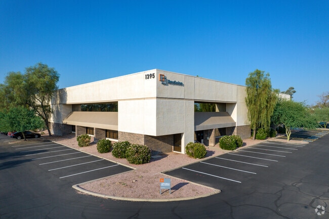
1395 N Hayden Rd, Scottsdale, AZ 85257


Current Lease Availabilities
NEARBY LISTINGS FOR SALE OR LEASE
Property Detail
1395 N Hayden Rd
131-09-002L
TH PT NW4 NW4 SEC 1 DAF BEG NW COR NW4 TH S 01D 35M W 944.28F TH S 88D 24M E 406.77F TO POB TH E 50.90F TO A PT ON ARC CIR TH NELY ALG ARC SD CIR C/A 67D 57M 118.62F TH S 67D 53M E 16F TH E 205. 67F TH S 343.02F TO A PT ON ARC CIR TH SWLY ALG ARC SD
Officebuilding
Maricopa
X
Arizona
04013C2235M
2.94 AC
2025
Scottsdale South
2025
Phoenix
218300
Phoenix-Mesa-Scottsdale, AZ
30,748 SF
DEMOGRAPHICS near 1395 N Hayden Rd
1 Mile
3 Mile
5 Mile
2024 Total Population
15,786
97,206
299,138
2029 Population
17,127
107,175
326,312
Pop Growth 2024-2029
+ 8.49%
+ 10.26%
+ 9.08%
Average Age
41
38
37
2024 Total Households
7,724
47,593
133,765
HH Growth 2024-2029
+ 8.58%
+ 10.50%
+ 9.52%
Median Household Inc
$77,114
$74,745
$65,982
Avg Household Size
1.90
1.90
2.10
2024 Avg HH Vehicles
2.00
2.00
2.00
Median Home Value
$357,232
$416,478
$428,018
Median Year Built
1975
1979
1980
Nearby Places
Map Layers
Map Styles
 Street
 Aerial
- Restaurants
- Banks
- Shops
- Fitness
- Groceries
PUBLIC TRANSPORTATION
AIRPORT
Phoenix Sky Harbor International
DRIVE
WALK
Distance
Phoenix Sky Harbor International
15 min
8.0 mi
Phoenix-Mesa Gateway
DRIVE
WALK
Distance
Phoenix-Mesa Gateway
38 min
25.5 mi
Nearby Properties
Address
Land Use
TOTAL SIZE
Lot Size
Zoning
Address
Land Use
TOTAL SIZE
Lot Size
Zoning
Address
Land Use
TOTAL SIZE
Lot Size
Zoning
4.59 AC
I-1
Address
Land Use
TOTAL SIZE
Lot Size
Zoning
1,870,689 SF
46.77 AC
I-P
Address
Land Use
TOTAL SIZE
Lot Size
Zoning
401,544 SF
64.59 AC
GID
Address
Land Use
TOTAL SIZE
Lot Size
Zoning
2.54 AC
Address
Land Use
TOTAL SIZE
Lot Size
Zoning
9,160 SF
2.57 AC
DDMU2
Address
Land Use
TOTAL SIZE
Lot Size
Zoning
649,656 SF
10.19 AC
PAD
Address
Land Use
TOTAL SIZE
Lot Size
Zoning
3.77 AC
PNC
Address
Land Use
TOTAL SIZE
Lot Size
Zoning
44,971 SF
2.06 AC
C-R
Address
Land Use
TOTAL SIZE
Lot Size
Zoning
58,061 SF
5.43 AC
C-C
Address
Land Use
TOTAL SIZE
Lot Size
Zoning
697,894 SF
8.43 AC
PAD
Address
Land Use
TOTAL SIZE
Lot Size
Zoning
3,010 SF
35.44 AC
R110
Address
Land Use
TOTAL SIZE
Lot Size
Zoning
8.79 AC
PF
Address
Land Use
TOTAL SIZE
Lot Size
Zoning
197,454 SF
18.97 AC
PF
Address
Land Use
TOTAL SIZE
Lot Size
Zoning
511,014 SF
5.01 AC
I-1
Address
Land Use
TOTAL SIZE
Lot Size
Zoning
307,604 SF
37.83 AC
R-7
Address
Land Use
TOTAL SIZE
Lot Size
Zoning
301,376 SF
8.77 AC
PAD
Address
Land Use
TOTAL SIZE
Lot Size
Zoning
776,898 SF
27.32 AC
C-R
Address
Land Use
TOTAL SIZE
Lot Size
Zoning
544,646 SF
1.65 AC
MU4
Address
Land Use
TOTAL SIZE
Lot Size
Zoning
401,437 SF
17.70 AC
C-R
Address
Land Use
TOTAL SIZE
Lot Size
Zoning
377,014 SF
1.81 AC
PAD
Address
Land Use
TOTAL SIZE
Lot Size
Zoning
640,230 SF
3.94 AC
MU4
Address
Land Use
TOTAL SIZE
Lot Size
Zoning
1,229,384 SF
4.81 AC
Address
Land Use
TOTAL SIZE
Lot Size
Zoning
469,012 SF
11.39 AC
I-1
Address
Land Use
TOTAL SIZE
Lot Size
Zoning
420,534 SF
1.62 AC
PAD
The World's #1 Commercial Real Estate Marketplace
Connect with us
© 2026 CoStar Group
The information above has been obtained from sources believed reliable. While we do not doubt its accuracy we have not verified it and make no guarantee, warranty or representation about it. It is your responsibility to independently confirm its accuracy and completeness. Any projections, opinions, assumptions, or estimates used are for example only and do not represent the current or future performance of the property. The value of this transaction to you depends on tax and other factors which should be evaluated by your tax, financial, and legal advisors. You and your advisors should conduct a careful, independent investigation of the property to determine to your satisfaction the suitability of the property for your needs.