Property Record
1396 S Highway 231, Ozark, AL 36360
NEARBY LISTINGS FOR SALE OR LEASE
-
-
View all Ozark listings for sale on LoopNet.com
Property Detail
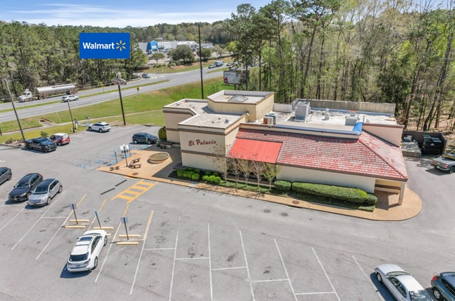
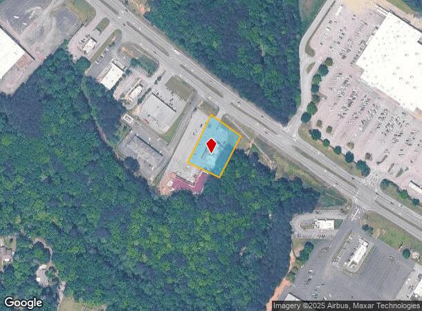
1396 S Highway 231
06-08-33-3-000-080.0050
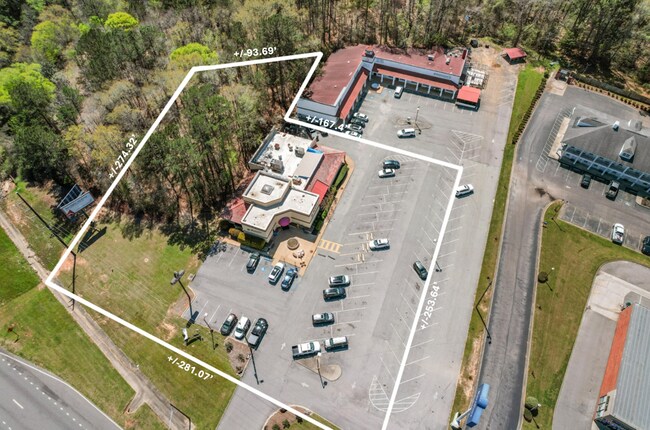
0.92 AC(D), 170' X 253.54' IRR, LOT IN PT SW1/4-SW1/4 BEG 300'S ELY OF INT SW R/W OF HWY 231 & W LINE OF SEC; SWLY 253.54'; SELY 167.4'; NELY 224'; NWLY 170' TO POB. OZARK AL. SEC 33 TWP 6N RNG 24E. DB 131 PG 746 DATE 3/31/86 DB 131 PG 332 DATE 2/2/8
Restaurantbuilding
Dale
X
Alabama
01045C0135D
0.92 AC
2025
Dothan/Enterprise
2024
Other Market Areas
020700
Ozark, AL
6,556 SF
DEMOGRAPHICS near 1396 S Highway 231
1 Mile
3 Mile
5 Mile
2024 Total Population
3,176
10,626
15,729
2029 Population
3,331
11,046
16,313
Pop Growth 2024-2029
+ 4.88%
+ 3.95%
+ 3.71%
Average Age
40
42
42
2024 Total Households
1,396
4,641
6,729
HH Growth 2024-2029
+ 5.01%
+ 4.16%
+ 3.91%
Median Household Inc
$41,017
$39,977
$43,494
Avg Household Size
2.20
2.20
2.30
2024 Avg HH Vehicles
2.00
2.00
2.00
Median Home Value
$126,205
$138,522
$134,503
Median Year Built
1968
1971
1975
Nearby Places
Map Layers
Map Styles
 Street
 Aerial
- Restaurants
- Banks
- Shops
- Fitness
- Groceries
PUBLIC TRANSPORTATION
AIRPORT
Dothan Regional
DRIVE
WALK
Distance
Dothan Regional
27 min
17.4 mi
SALE & LEASE HISTORY
LISTING DATE
SALE/LEASE

Apr 12, 2025
For Sale
Nearby Properties
Address
Land Use
TOTAL SIZE
Lot Size
Zoning
Address
Land Use
TOTAL SIZE
Lot Size
Zoning
7.90 AC
Address
Land Use
TOTAL SIZE
Lot Size
Zoning
160,913 SF
24.70 AC
Address
Land Use
TOTAL SIZE
Lot Size
Zoning
220,000 SF
42.61 AC
Address
Land Use
TOTAL SIZE
Lot Size
Zoning
17,220 SF
0.50 AC
Address
Land Use
TOTAL SIZE
Lot Size
Zoning
10,552 SF
9.30 AC
Address
Land Use
TOTAL SIZE
Lot Size
Zoning
1,902 SF
10 AC
Address
Land Use
TOTAL SIZE
Lot Size
Zoning
12,464 SF
3 AC
O
Address
Land Use
TOTAL SIZE
Lot Size
Zoning
30 AC
Address
Land Use
TOTAL SIZE
Lot Size
Zoning
4.04 AC
Address
Land Use
TOTAL SIZE
Lot Size
Zoning
8,490 SF
1.96 AC
Address
Land Use
TOTAL SIZE
Lot Size
Zoning
1.80 AC
Address
Land Use
TOTAL SIZE
Lot Size
Zoning
0.96 AC
Address
Land Use
TOTAL SIZE
Lot Size
Zoning
12,800 SF
6.50 AC
Address
Land Use
TOTAL SIZE
Lot Size
Zoning
1,680 SF
2.65 AC
Address
Land Use
TOTAL SIZE
Lot Size
Zoning
16,224 SF
1.70 AC
Address
Land Use
TOTAL SIZE
Lot Size
Zoning
3,780 SF
2.50 AC
Address
Land Use
TOTAL SIZE
Lot Size
Zoning
25,828 SF
7.20 AC
Address
Land Use
TOTAL SIZE
Lot Size
Zoning
29,600 SF
8.20 AC
Address
Land Use
TOTAL SIZE
Lot Size
Zoning
14 AC
Address
Land Use
TOTAL SIZE
Lot Size
Zoning
860 SF
2.90 AC
Address
Land Use
TOTAL SIZE
Lot Size
Zoning
16 AC
Address
Land Use
TOTAL SIZE
Lot Size
Zoning
Address
Land Use
TOTAL SIZE
Lot Size
Zoning
7.50 AC
Address
Land Use
TOTAL SIZE
Lot Size
Zoning
5.89 AC
Address
Land Use
TOTAL SIZE
Lot Size
Zoning
12,000 SF
1.70 AC
Address
Land Use
TOTAL SIZE
Lot Size
Zoning
8,064 SF
11.70 AC
Address
Land Use
TOTAL SIZE
Lot Size
Zoning
Address
Land Use
TOTAL SIZE
Lot Size
Zoning
7.76 AC
Address
Land Use
TOTAL SIZE
Lot Size
Zoning
7,632 SF
3.35 AC
The World's #1 Commercial Real Estate Marketplace
Connect with us
© 2026 CoStar Group
The information above has been obtained from sources believed reliable. While we do not doubt its accuracy we have not verified it and make no guarantee, warranty or representation about it. It is your responsibility to independently confirm its accuracy and completeness. Any projections, opinions, assumptions, or estimates used are for example only and do not represent the current or future performance of the property. The value of this transaction to you depends on tax and other factors which should be evaluated by your tax, financial, and legal advisors. You and your advisors should conduct a careful, independent investigation of the property to determine to your satisfaction the suitability of the property for your needs.