Property Record
13964 N Ohio St, Rathdrum, ID 83858
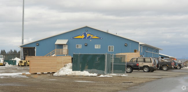

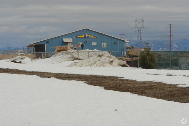
Property Detail
13964 N Ohio St
Coeur d'Alene, ID
THAYER 5TH ADD, TAX#25636 [IN LT 1 BLOCK 2 & PTN THAYER 2ND ADD LT 1 BLOCK 1] 0651N04W
R7910002001A
Kootenai
Industrialgeneral
Idaho
B and X Area of moderate flood hazard, usually the area between the limits of the 100-year and 500-year floods.
1
2025
12.50 AC
2025
Hayden/Dalton Gardens
000303
Coeur D'Alene
11,620 SF
NEARBY LISTINGS FOR SALE OR LEASE
DEMOGRAPHICS near 13964 N Ohio St
1 mile
3 mile
5 mile
2025 Total Population
6,567
13,073
40,171
2030 Population
7,000
13,976
42,647
Pop Growth 2025-2030
+ 6.59%
+ 6.91%
+ 6.16%
Average Age
39
39
39
2025 Total Households
2,391
4,719
14,603
HH Growth 2025-2030
+ 6.69%
+ 6.99%
+ 6.28%
Median Household Inc
$79,353
$83,710
$89,671
Avg Household Size
2.70
2.70
2.70
2025 Avg HH Vehicles
2.00
2.00
2.00
Median Home Value
$473,138
$501,640
$571,732
Median Year Built
2005
2005
2008
Nearby Places
Map Layers
Map Styles
 Street
 Aerial
Layers
 Traffic
 Biking
Places
Listings with unknown addresses are not visible on the map
- Restaurants
- Banks
- Shops
- Fitness
- Groceries
Nearby Properties
Address
Land Use
TOTAL SIZE
Lot Size
Zoning
Address
Land Use
TOTAL SIZE
Lot Size
Zoning
20,822 SF
10.32 AC
AG
Address
Land Use
TOTAL SIZE
Lot Size
Zoning
125,872 SF
37.45 AC
Address
Land Use
TOTAL SIZE
Lot Size
Zoning
12,600 SF
29.04 AC
Address
Land Use
TOTAL SIZE
Lot Size
Zoning
14,159 SF
17.50 AC
Address
Land Use
TOTAL SIZE
Lot Size
Zoning
54,488 SF
19.50 AC
Address
Land Use
TOTAL SIZE
Lot Size
Zoning
124,611 SF
30.51 AC
AGSUB
Address
Land Use
TOTAL SIZE
Lot Size
Zoning
134,124 SF
43.63 AC
AG
Address
Land Use
TOTAL SIZE
Lot Size
Zoning
23,784 SF
7 AC
Address
Land Use
TOTAL SIZE
Lot Size
Zoning
48,264 SF
10.87 AC
Address
Land Use
TOTAL SIZE
Lot Size
Zoning
47,716 SF
17.22 AC
Address
Land Use
TOTAL SIZE
Lot Size
Zoning
88,688 SF
20.51 AC
Address
Land Use
TOTAL SIZE
Lot Size
Zoning
49,446 SF
5.25 AC
Address
Land Use
TOTAL SIZE
Lot Size
Zoning
720 SF
291.71 AC
AG
Address
Land Use
TOTAL SIZE
Lot Size
Zoning
52,690 SF
7.13 AC
Address
Land Use
TOTAL SIZE
Lot Size
Zoning
24,698 SF
5.02 AC
AGSUB
Address
Land Use
TOTAL SIZE
Lot Size
Zoning
42,000 SF
2.54 AC
Address
Land Use
TOTAL SIZE
Lot Size
Zoning
68,580 SF
4.36 AC
Address
Land Use
TOTAL SIZE
Lot Size
Zoning
60,220 SF
2.70 AC
Address
Land Use
TOTAL SIZE
Lot Size
Zoning
10,892 SF
38.79 AC
Address
Land Use
TOTAL SIZE
Lot Size
Zoning
15.19 AC
Address
Land Use
TOTAL SIZE
Lot Size
Zoning
10.56 AC
Address
Land Use
TOTAL SIZE
Lot Size
Zoning
31,880 SF
3.18 AC
Address
Land Use
TOTAL SIZE
Lot Size
Zoning
Address
Land Use
TOTAL SIZE
Lot Size
Zoning
34,635 SF
4.99 AC
Address
Land Use
TOTAL SIZE
Lot Size
Zoning
37,756 SF
2.89 AC
Address
Land Use
TOTAL SIZE
Lot Size
Zoning
808 SF
163.70 AC
AG
Address
Land Use
TOTAL SIZE
Lot Size
Zoning
29,190 SF
10.38 AC
Address
Land Use
TOTAL SIZE
Lot Size
Zoning
11,003 SF
2.07 AC
Address
Land Use
TOTAL SIZE
Lot Size
Zoning
25,785 SF
1.83 AC
The World's #1 Commercial Real Estate Marketplace
Connect with us
© 2026 CoStar Group
The information above has been obtained from sources believed reliable. While we do not doubt its accuracy we have not verified it and make no guarantee, warranty or representation about it. It is your responsibility to independently confirm its accuracy and completeness. Any projections, opinions, assumptions, or estimates used are for example only and do not represent the current or future performance of the property. The value of this transaction to you depends on tax and other factors which should be evaluated by your tax, financial, and legal advisors. You and your advisors should conduct a careful, independent investigation of the property to determine to your satisfaction the suitability of the property for your needs.