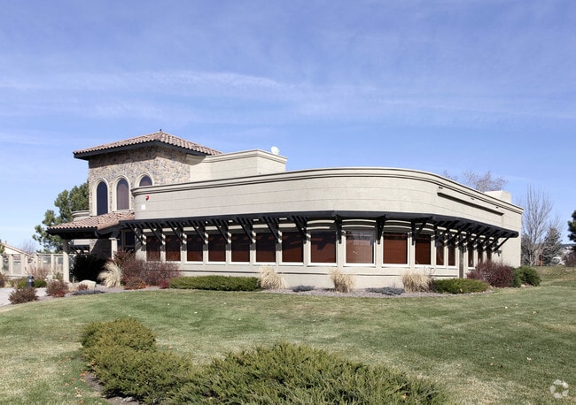
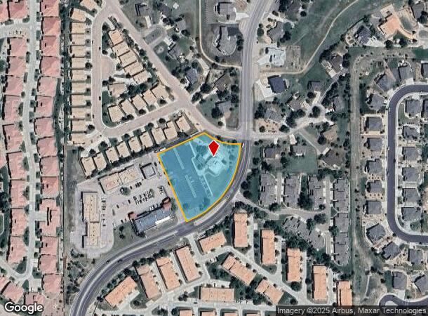
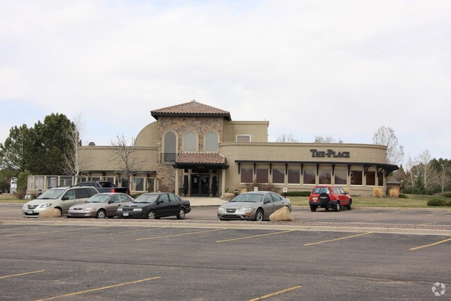
Property Record
13990 Gleneagle Dr, Colorado Springs, CO 80921

NEARBY LISTINGS FOR SALE OR LEASE
Property Detail
13990 Gleneagle Dr
Colorado Springs, CO
Berkshire Center Fil No 5
62063-04-024
LOT 5 SHOPPE IN THE GLEN
Religious
El Paso
X
Colorado
08041C0287G
5
0
1.92 AC
2025
Northeast
007203
Colorado Springs
7,974 SF
DEMOGRAPHICS near 13990 Gleneagle Dr
1 Mile
3 Mile
5 Mile
2024 Total Population
5,899
31,106
57,852
2029 Population
6,145
32,751
61,013
Pop Growth 2024-2029
+ 4.17%
+ 5.29%
+ 5.46%
Average Age
41
40
39
2024 Total Households
2,112
11,104
19,894
HH Growth 2024-2029
+ 4.40%
+ 5.52%
+ 5.78%
Median Household Inc
$118,511
$135,745
$132,264
Avg Household Size
2.80
2.80
2.80
2024 Avg HH Vehicles
2.00
2.00
2.00
Median Home Value
$482,337
$603,116
$624,947
Median Year Built
2002
2006
2004
Nearby Places
Map Layers
Map Styles
 Street
 Aerial
- Restaurants
- Banks
- Shops
- Fitness
- Groceries
PUBLIC TRANSPORTATION
AIRPORT
City of Colorado Springs Municipal
DRIVE
WALK
Distance
City of Colorado Springs Municipal
34 min
20.9 mi
Freight Ports
Tulsa Port Of Catoosa
DRIVE
WALK
Distance
Tulsa Port Of Catoosa
743 min
695.9 mi
Nearby Properties
Address
Land Use
TOTAL SIZE
Lot Size
Zoning
Address
Land Use
TOTAL SIZE
Lot Size
Zoning
278,951 SF
32.43 AC
BP/CR HR
Address
Land Use
TOTAL SIZE
Lot Size
Zoning
136,906 SF
25.22 AC
PRD-4
Address
Land Use
TOTAL SIZE
Lot Size
Zoning
562,942 SF
27.13 AC
PDZ
Address
Land Use
TOTAL SIZE
Lot Size
Zoning
112,266 SF
0.24 AC
RR3
Address
Land Use
TOTAL SIZE
Lot Size
Zoning
316,105 SF
19.73 AC
PDZ
Address
Land Use
TOTAL SIZE
Lot Size
Zoning
323,646 SF
31.30 AC
A BP/CR BP
Address
Land Use
TOTAL SIZE
Lot Size
Zoning
10,000 SF
23.39 AC
PUD
Address
Land Use
TOTAL SIZE
Lot Size
Zoning
45,186 SF
8.91 AC
PUD
Address
Land Use
TOTAL SIZE
Lot Size
Zoning
68,829 SF
6 AC
BP/CR
Address
Land Use
TOTAL SIZE
Lot Size
Zoning
188,626 SF
22.34 AC
BP/CR HR
Address
Land Use
TOTAL SIZE
Lot Size
Zoning
22,970 SF
5.45 AC
PUD
Address
Land Use
TOTAL SIZE
Lot Size
Zoning
181,852 SF
20.99 AC
BP/CR HR
Address
Land Use
TOTAL SIZE
Lot Size
Zoning
154,703 SF
14.29 AC
BP HR
Address
Land Use
TOTAL SIZE
Lot Size
Zoning
411,465 SF
22.54 AC
PDZ
Address
Land Use
TOTAL SIZE
Lot Size
Zoning
355,799 SF
10.51 AC
PDZ HR
Address
Land Use
TOTAL SIZE
Lot Size
Zoning
132,854 SF
10 AC
BP/CR HR
Address
Land Use
TOTAL SIZE
Lot Size
Zoning
600 SF
25.36 AC
A
Address
Land Use
TOTAL SIZE
Lot Size
Zoning
23,378 SF
3.34 AC
PUD
Address
Land Use
TOTAL SIZE
Lot Size
Zoning
20,752 SF
1.27 AC
BP HR
Address
Land Use
TOTAL SIZE
Lot Size
Zoning
222,850 SF
20.55 AC
PUD
Address
Land Use
TOTAL SIZE
Lot Size
Zoning
347,470 SF
15.42 AC
PDZ HR
Address
Land Use
TOTAL SIZE
Lot Size
Zoning
206,674 SF
3.86 AC
PDZ
Address
Land Use
TOTAL SIZE
Lot Size
Zoning
266,793 SF
15.68 AC
PDZ
Address
Land Use
TOTAL SIZE
Lot Size
Zoning
51,034 SF
11.01 AC
PDZ HR
Address
Land Use
TOTAL SIZE
Lot Size
Zoning
119,596 SF
19.25 AC
PDZ HR
Address
Land Use
TOTAL SIZE
Lot Size
Zoning
98,428 SF
16.92 AC
PUD
Address
Land Use
TOTAL SIZE
Lot Size
Zoning
86,779 SF
10.62 AC
PCD
Address
Land Use
TOTAL SIZE
Lot Size
Zoning
83,922 SF
16.29 AC
A
Address
Land Use
TOTAL SIZE
Lot Size
Zoning
17,655 SF
7.01 AC
R-4
Address
Land Use
TOTAL SIZE
Lot Size
Zoning
15.39 AC
BP/CR HR
The World's #1 Commercial Real Estate Marketplace
Connect with us
© 2025 CoStar Group
The information above has been obtained from sources believed reliable. While we do not doubt its accuracy we have not verified it and make no guarantee, warranty or representation about it. It is your responsibility to independently confirm its accuracy and completeness. Any projections, opinions, assumptions, or estimates used are for example only and do not represent the current or future performance of the property. The value of this transaction to you depends on tax and other factors which should be evaluated by your tax, financial, and legal advisors. You and your advisors should conduct a careful, independent investigation of the property to determine to your satisfaction the suitability of the property for your needs.