Property Record
139Th St, Basehor, KS 66007

Property Detail
139Th St
Kansas City, MO-KS
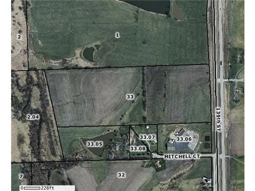
S25, T10, R22E, ACRES 45.1, S1/2NE1/4 LESS S485 OF E2194 & LESS A TRACT BEG SW COR SW1/4,NE1/4,N1322.38,E216.78 SELY 1346.48,W477.02 TO POB
157-25-0-00-00-033.00-0
LEAVENWORTH
Agriculturalland
Kansas
B and X Area of moderate flood hazard, usually the area between the limits of the 100-year and 500-year floods.
45.10 AC
2024
Leavenworth County
2025
Kansas City
071204
NEARBY LISTINGS FOR SALE OR LEASE
DEMOGRAPHICS near 139Th St
1 mile
3 mile
5 mile
2025 Total Population
813
12,719
29,543
2030 Population
857
13,066
30,351
Pop Growth 2025-2030
+ 5.41%
+ 2.73%
+ 2.73%
Average Age
42
40
40
2025 Total Households
294
4,749
10,971
HH Growth 2025-2030
+ 5.44%
+ 2.78%
+ 2.80%
Median Household Inc
$145,108
$106,145
$111,399
Avg Household Size
2.80
2.70
2.70
2025 Avg HH Vehicles
3.00
2.00
2.00
Median Home Value
$399,241
$330,483
$343,274
Median Year Built
2005
2002
2001
Nearby Places
Map Layers
Map Styles
 Street
 Aerial
Transit
 Traffic
 Biking
Places
Listings with unknown addresses are not visible on the map
- Restaurants
- Banks
- Shops
- Fitness
- Groceries
PUBLIC TRANSPORTATION
AIRPORT
Kansas City International
Drive
Walk
Distance
Kansas City International
36 min
24.9 mi
Freight Ports
Tulsa Port Of Catoosa
Drive
Walk
Distance
Tulsa Port Of Catoosa
278 min
247.0 mi
SALE & LEASE HISTORY
LISTING DATE
SALE/LEASE

Sep 24, 2016
For Sale
Nearby Properties
Address
Land Use
TOTAL SIZE
Lot Size
Zoning
Address
Land Use
TOTAL SIZE
Lot Size
Zoning
139,516 SF
73.61 AC
Address
Land Use
TOTAL SIZE
Lot Size
Zoning
169,410 SF
37.81 AC
Address
Land Use
TOTAL SIZE
Lot Size
Zoning
77,925 SF
11.31 AC
Address
Land Use
TOTAL SIZE
Lot Size
Zoning
118,146 SF
19.85 AC
WR1B
Address
Land Use
TOTAL SIZE
Lot Size
Zoning
86,176 SF
49.23 AC
KAG
Address
Land Use
TOTAL SIZE
Lot Size
Zoning
69,406 SF
29.75 AC
Address
Land Use
TOTAL SIZE
Lot Size
Zoning
24,933 SF
17.16 AC
KAG
Address
Land Use
TOTAL SIZE
Lot Size
Zoning
27,279 SF
17.93 AC
Address
Land Use
TOTAL SIZE
Lot Size
Zoning
39,215 SF
18.35 AC
Address
Land Use
TOTAL SIZE
Lot Size
Zoning
48,590 SF
4.72 AC
Address
Land Use
TOTAL SIZE
Lot Size
Zoning
27,568 SF
6.57 AC
WR1
Address
Land Use
TOTAL SIZE
Lot Size
Zoning
30,800 SF
108.93 AC
WYAG
Address
Land Use
TOTAL SIZE
Lot Size
Zoning
19,753 SF
4.83 AC
Address
Land Use
TOTAL SIZE
Lot Size
Zoning
10,320 SF
38.08 AC
Address
Land Use
TOTAL SIZE
Lot Size
Zoning
9,100 SF
0.64 AC
Address
Land Use
TOTAL SIZE
Lot Size
Zoning
73.91 AC
Address
Land Use
TOTAL SIZE
Lot Size
Zoning
61.74 AC
WYAG
Address
Land Use
TOTAL SIZE
Lot Size
Zoning
33,125 SF
5.20 AC
Address
Land Use
TOTAL SIZE
Lot Size
Zoning
8,085 SF
3.08 AC
WR
Address
Land Use
TOTAL SIZE
Lot Size
Zoning
5,262 SF
1.94 AC
Address
Land Use
TOTAL SIZE
Lot Size
Zoning
7,563 SF
8.05 AC
Address
Land Use
TOTAL SIZE
Lot Size
Zoning
62,774 SF
4.82 AC
Address
Land Use
TOTAL SIZE
Lot Size
Zoning
13,867 SF
3 AC
Address
Land Use
TOTAL SIZE
Lot Size
Zoning
43,170 SF
6.25 AC
Address
Land Use
TOTAL SIZE
Lot Size
Zoning
33,368 SF
1.68 AC
Address
Land Use
TOTAL SIZE
Lot Size
Zoning
17,592 SF
203.39 AC
WAG
Address
Land Use
TOTAL SIZE
Lot Size
Zoning
3,801 SF
9.51 AC
WR1
Address
Land Use
TOTAL SIZE
Lot Size
Zoning
2,628 SF
19.44 AC
WAG
Address
Land Use
TOTAL SIZE
Lot Size
Zoning
271,824 SF
137.72 AC
WAG
Address
Land Use
TOTAL SIZE
Lot Size
Zoning
The World's #1 Commercial Real Estate Marketplace
Connect with us
© 2026 CoStar Group
The information above has been obtained from sources believed reliable. While we do not doubt its accuracy we have not verified it and make no guarantee, warranty or representation about it. It is your responsibility to independently confirm its accuracy and completeness. Any projections, opinions, assumptions, or estimates used are for example only and do not represent the current or future performance of the property. The value of this transaction to you depends on tax and other factors which should be evaluated by your tax, financial, and legal advisors. You and your advisors should conduct a careful, independent investigation of the property to determine to your satisfaction the suitability of the property for your needs.