Property Record
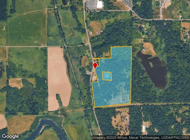
13606 Carnation Duvall Rd Ne, Duvall, WA 98019

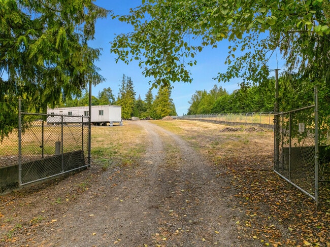
This Property Is For Sale
NEARBY LISTINGS FOR SALE OR LEASE
Property Detail
13606 Carnation Duvall Rd Ne
Seattle-Tacoma-Bellevue, WA
POR OF SW 1/4 LY ELY OF SR 203 (CARNATION DUVALL RD NE) & SLY OF LN DAF - BEG AT SE COR OF SD SUBD TH N 01-54-29 E 1931.24 FT TO TPOB OF SD LN TH S 89-22-05 W 694.33 FT TH S 01-54-29 W PLW E LN OF SD SUBD 371.54 FT TH S 89-32-05 W TO ELY MGN OF SD SR
242606-9012
King
Residentialacreage
Washington
X
242606
53033C0401G
49.25 AC
2025
E King County
2024
Seattle/Puget Sound
0324024010
DEMOGRAPHICS near 13606 Carnation Duvall Rd Ne
1 Mile
3 Mile
5 Mile
2024 Total Population
1,468
18,663
43,744
2029 Population
1,567
19,399
45,257
Pop Growth 2024-2029
+ 6.74%
+ 3.94%
+ 3.46%
Average Age
39
43
42
2024 Total Households
500
6,916
15,364
HH Growth 2024-2029
+ 6.80%
+ 3.90%
+ 3.46%
Median Household Inc
$151,064
$161,575
$182,283
Avg Household Size
2.90
2.70
2.80
2024 Avg HH Vehicles
2.00
2.00
2.00
Median Home Value
$781,762
$914,595
$1,029,254
Median Year Built
2001
2002
1996
Nearby Places
- Restaurants
- Banks
- Shops
- Fitness
- Groceries
PUBLIC TRANSPORTATION
AIRPORT
Seattle Paine Field International
DRIVE
WALK
Distance
Seattle Paine Field International
46 min
27.2 mi
Seattle-Tacoma International
DRIVE
WALK
Distance
Seattle-Tacoma International
49 min
32.4 mi
Freight Ports
Port of Everett
DRIVE
WALK
Distance
Port of Everett
42 min
27.1 mi
Nearby Properties
Address
Land Use
TOTAL SIZE
Lot Size
Zoning
Address
Land Use
TOTAL SIZE
Lot Size
Zoning
168,648 SF
7.30 AC
IP
Address
Land Use
TOTAL SIZE
Lot Size
Zoning
140,426 SF
4.82 AC
R24
Address
Land Use
TOTAL SIZE
Lot Size
Zoning
160,993 SF
5.21 AC
R24
Address
Land Use
TOTAL SIZE
Lot Size
Zoning
78,000 SF
10.10 AC
R6
Address
Land Use
TOTAL SIZE
Lot Size
Zoning
89,100 SF
3.40 AC
IP
Address
Land Use
TOTAL SIZE
Lot Size
Zoning
67,700 SF
2.62 AC
OPSO
Address
Land Use
TOTAL SIZE
Lot Size
Zoning
93,333 SF
42.85 AC
PF
Address
Land Use
TOTAL SIZE
Lot Size
Zoning
50,615 SF
3.37 AC
IP
Address
Land Use
TOTAL SIZE
Lot Size
Zoning
57,207 SF
4.31 AC
OPSO
Address
Land Use
TOTAL SIZE
Lot Size
Zoning
89,407 SF
0.95 AC
LI
Address
Land Use
TOTAL SIZE
Lot Size
Zoning
70,465 SF
5.26 AC
IP
Address
Land Use
TOTAL SIZE
Lot Size
Zoning
70,800 SF
4.02 AC
IP
Address
Land Use
TOTAL SIZE
Lot Size
Zoning
19,532 SF
3.32 AC
CBP
Address
Land Use
TOTAL SIZE
Lot Size
Zoning
39,250 SF
3.26 AC
OP
Address
Land Use
TOTAL SIZE
Lot Size
Zoning
47,425 SF
3.20 AC
IP
Address
Land Use
TOTAL SIZE
Lot Size
Zoning
54,374 SF
5.38 AC
CBP
Address
Land Use
TOTAL SIZE
Lot Size
Zoning
44,072 SF
3.86 AC
IP
Address
Land Use
TOTAL SIZE
Lot Size
Zoning
30,905 SF
3.01 AC
OP
Address
Land Use
TOTAL SIZE
Lot Size
Zoning
40,625 SF
3.08 AC
IP
Address
Land Use
TOTAL SIZE
Lot Size
Zoning
45,015 SF
3.54 AC
IP
Address
Land Use
TOTAL SIZE
Lot Size
Zoning
40,991 SF
3.16 AC
OP
Address
Land Use
TOTAL SIZE
Lot Size
Zoning
44,816 SF
5.86 AC
CO
Address
Land Use
TOTAL SIZE
Lot Size
Zoning
41,244 SF
1.50 AC
MT
Address
Land Use
TOTAL SIZE
Lot Size
Zoning
41,061 SF
5.70 AC
IP
Address
Land Use
TOTAL SIZE
Lot Size
Zoning
37,864 SF
10.19 AC
PF
Address
Land Use
TOTAL SIZE
Lot Size
Zoning
2,940 SF
7.46 AC
PF
Address
Land Use
TOTAL SIZE
Lot Size
Zoning
28,044 SF
2.29 AC
R24
Address
Land Use
TOTAL SIZE
Lot Size
Zoning
4,641 SF
1.50 AC
MT
Address
Land Use
TOTAL SIZE
Lot Size
Zoning
26,000 SF
0.54 AC
MT
Address
Land Use
TOTAL SIZE
Lot Size
Zoning
34,412 SF
5.25 AC
LI
The World's #1 Commercial Real Estate Marketplace
Connect with us
© 2025 CoStar Group
The information above has been obtained from sources believed reliable. While we do not doubt its accuracy we have not verified it and make no guarantee, warranty or representation about it. It is your responsibility to independently confirm its accuracy and completeness. Any projections, opinions, assumptions, or estimates used are for example only and do not represent the current or future performance of the property. The value of this transaction to you depends on tax and other factors which should be evaluated by your tax, financial, and legal advisors. You and your advisors should conduct a careful, independent investigation of the property to determine to your satisfaction the suitability of the property for your needs.