Property Record
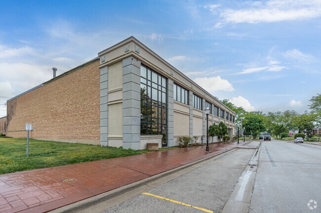
14 N Center St, Bensenville, IL 60106


This Property Is For Sale
NEARBY LISTINGS FOR SALE OR LEASE
Property Detail
14 N Center St
Chicago-Naperville-Elgin, IL-IN-WI
Tioga
03-14-215-025
TIOGA ALL & VAC ALLEY LYG W & ADJ ALL & VAC ALLEY LYG W & ADJ ALL
Industrialgeneral
DuPage
X
Illinois
17043C0079J
4
2024
0.56 AC
2024
O'Hare
840802
Chicago
31,332 SF
DEMOGRAPHICS near 14 N Center St
1 Mile
3 Mile
5 Mile
2024 Total Population
11,050
45,645
214,043
2029 Population
10,850
44,462
208,699
Pop Growth 2024-2029
(1.81%)
(2.59%)
(2.50%)
Average Age
40
40
40
2024 Total Households
3,651
16,014
75,674
HH Growth 2024-2029
(1.89%)
(2.78%)
(2.69%)
Median Household Inc
$68,835
$74,451
$78,355
Avg Household Size
2.80
2.70
2.70
2024 Avg HH Vehicles
2.00
2.00
2.00
Median Home Value
$246,608
$271,513
$279,030
Median Year Built
1970
1968
1966
Nearby Places
Map Layers
Map Styles
 Street
 Aerial
- Restaurants
- Banks
- Shops
- Fitness
- Groceries
PUBLIC TRANSPORTATION
COMMUTER RAIL
Bensenville Station (Milwaukee District West Line - Northeast Illinois Regional Commuter Railroad (Metra))
DRIVE
WALK
Distance
Bensenville Station (Milwaukee District West Line - Northeast Illinois Regional Commuter Railroad (Metra))
1 min
3 min
0.2 mi
Wood Dale Station (Milwaukee District West Line - Northeast Illinois Regional Commuter Railroad (Metra))
DRIVE
WALK
Distance
Wood Dale Station (Milwaukee District West Line - Northeast Illinois Regional Commuter Railroad (Metra))
4 min
1.9 mi
AIRPORT
Chicago O'Hare International
DRIVE
WALK
Distance
Chicago O'Hare International
12 min
7.4 mi
Chicago Midway International
DRIVE
WALK
Distance
Chicago Midway International
33 min
20.0 mi
Freight Ports
Port Milwaukee
DRIVE
WALK
Distance
Port Milwaukee
96 min
81.0 mi
Nearby Properties
Address
Land Use
TOTAL SIZE
Lot Size
Zoning
Address
Land Use
TOTAL SIZE
Lot Size
Zoning
820,106 SF
14.78 AC
Address
Land Use
TOTAL SIZE
Lot Size
Zoning
Address
Land Use
TOTAL SIZE
Lot Size
Zoning
310,751 SF
15.04 AC
Address
Land Use
TOTAL SIZE
Lot Size
Zoning
333,258 SF
9.48 AC
Address
Land Use
TOTAL SIZE
Lot Size
Zoning
189,290 SF
9.51 AC
Address
Land Use
TOTAL SIZE
Lot Size
Zoning
208,000 SF
10.35 AC
Address
Land Use
TOTAL SIZE
Lot Size
Zoning
132,699 SF
6.74 AC
Address
Land Use
TOTAL SIZE
Lot Size
Zoning
179,780 SF
8.12 AC
I
Address
Land Use
TOTAL SIZE
Lot Size
Zoning
17.67 AC
Address
Land Use
TOTAL SIZE
Lot Size
Zoning
4,100 SF
PD 0
Address
Land Use
TOTAL SIZE
Lot Size
Zoning
17.73 AC
Address
Land Use
TOTAL SIZE
Lot Size
Zoning
14.76 AC
Address
Land Use
TOTAL SIZE
Lot Size
Zoning
15.32 AC
Address
Land Use
TOTAL SIZE
Lot Size
Zoning
15.29 AC
Address
Land Use
TOTAL SIZE
Lot Size
Zoning
28.36 AC
Address
Land Use
TOTAL SIZE
Lot Size
Zoning
14.35 AC
Address
Land Use
TOTAL SIZE
Lot Size
Zoning
469,492 SF
14.87 AC
I
Address
Land Use
TOTAL SIZE
Lot Size
Zoning
14.37 AC
I
Address
Land Use
TOTAL SIZE
Lot Size
Zoning
Address
Land Use
TOTAL SIZE
Lot Size
Zoning
4,100 SF
PD 0
Address
Land Use
TOTAL SIZE
Lot Size
Zoning
441,232 SF
34.52 AC
I
Address
Land Use
TOTAL SIZE
Lot Size
Zoning
338,816 SF
16.84 AC
I
Address
Land Use
TOTAL SIZE
Lot Size
Zoning
193,020 SF
8.94 AC
I
Address
Land Use
TOTAL SIZE
Lot Size
Zoning
668,072 SF
4.19 AC
Address
Land Use
TOTAL SIZE
Lot Size
Zoning
28,774 SF
4.30 AC
C
Address
Land Use
TOTAL SIZE
Lot Size
Zoning
139,923 SF
11.98 AC
I
Address
Land Use
TOTAL SIZE
Lot Size
Zoning
420,601 SF
19.13 AC
Address
Land Use
TOTAL SIZE
Lot Size
Zoning
186,486 SF
2.43 AC
A
Address
Land Use
TOTAL SIZE
Lot Size
Zoning
256,686 SF
10.60 AC
I
Address
Land Use
TOTAL SIZE
Lot Size
Zoning
15.33 AC
M
The World's #1 Commercial Real Estate Marketplace
Connect with us
© 2026 CoStar Group
The information above has been obtained from sources believed reliable. While we do not doubt its accuracy we have not verified it and make no guarantee, warranty or representation about it. It is your responsibility to independently confirm its accuracy and completeness. Any projections, opinions, assumptions, or estimates used are for example only and do not represent the current or future performance of the property. The value of this transaction to you depends on tax and other factors which should be evaluated by your tax, financial, and legal advisors. You and your advisors should conduct a careful, independent investigation of the property to determine to your satisfaction the suitability of the property for your needs.