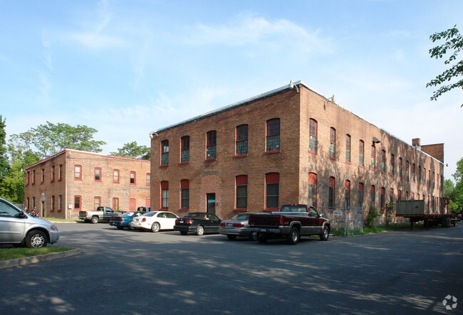
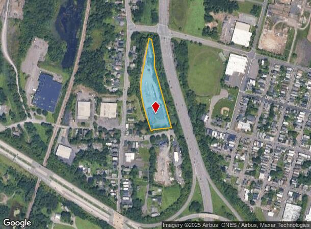
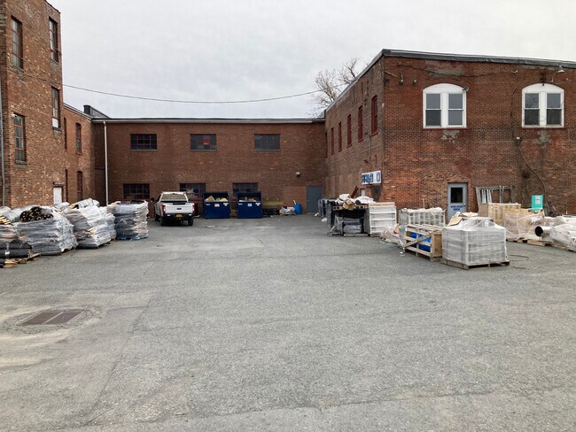
Property Record
14 Arch St, Watervliet, NY 12189
NEARBY LISTINGS FOR SALE OR LEASE
Property Detail
14 Arch St
012689-020-020-0002-028-000-0000
LOT & MFG N-TN LINE E-N Y S N-6-87
Warehouse
Albany
AE
New York
36083C0227D
28.000
2025
4.30 AC
2024
E Outer Albany County
013509
Albany/Schenectady/Troy
38,966 SF
Albany-Schenectady-Troy, NY
DEMOGRAPHICS near 14 Arch St
1 Mile
3 Mile
5 Mile
2024 Total Population
8,089
95,971
153,204
2029 Population
7,906
94,533
151,672
Pop Growth 2024-2029
(2.26%)
(1.50%)
(1.00%)
Average Age
38
38
40
2024 Total Households
3,703
40,732
64,656
HH Growth 2024-2029
(2.48%)
(1.65%)
(1.10%)
Median Household Inc
$43,162
$56,853
$67,617
Avg Household Size
2.10
2.10
2.20
2024 Avg HH Vehicles
1.00
1.00
1.00
Median Home Value
$156,964
$199,458
$237,838
Median Year Built
1948
1952
1960
Nearby Places
- Restaurants
- Banks
- Shops
- Fitness
- Groceries
PUBLIC TRANSPORTATION
COMMUTER RAIL
DRIVE
WALK
Distance
16 min
9.5 mi
AIRPORT
Albany International
DRIVE
WALK
Distance
Albany International
12 min
7.3 mi
Freight Ports
Albany, NY Port
DRIVE
WALK
Distance
Albany, NY Port
16 min
9.9 mi
SALE & LEASE HISTORY
LISTING DATE
SALE/LEASE

Jul 15, 2022
For Sale
Nearby Properties
Address
Land Use
TOTAL SIZE
Lot Size
Zoning
Address
Land Use
TOTAL SIZE
Lot Size
Zoning
34,971 SF
108.68 AC
CI
Address
Land Use
TOTAL SIZE
Lot Size
Zoning
313,907 SF
8.23 AC
CI
Address
Land Use
TOTAL SIZE
Lot Size
Zoning
9,643 SF
5.36 AC
CI
Address
Land Use
TOTAL SIZE
Lot Size
Zoning
Address
Land Use
TOTAL SIZE
Lot Size
Zoning
326,350 SF
11.11 AC
I
Address
Land Use
TOTAL SIZE
Lot Size
Zoning
413,006 SF
37.94 AC
CI
Address
Land Use
TOTAL SIZE
Lot Size
Zoning
67,335 SF
65.54 AC
CI
Address
Land Use
TOTAL SIZE
Lot Size
Zoning
150,000 SF
45.60 AC
07 - MIXED
Address
Land Use
TOTAL SIZE
Lot Size
Zoning
365,400 SF
73.90 AC
04 - FARM
Address
Land Use
TOTAL SIZE
Lot Size
Zoning
38,176 SF
8.99 AC
06 - INDUS
Address
Land Use
TOTAL SIZE
Lot Size
Zoning
3,214 SF
412.83 AC
18
Address
Land Use
TOTAL SIZE
Lot Size
Zoning
70,548 SF
2.71 AC
DMU
Address
Land Use
TOTAL SIZE
Lot Size
Zoning
82,154 SF
3.62 AC
DMU
Address
Land Use
TOTAL SIZE
Lot Size
Zoning
18,144 SF
58.78 AC
25
Address
Land Use
TOTAL SIZE
Lot Size
Zoning
11,264 SF
34.83 AC
MF
Address
Land Use
TOTAL SIZE
Lot Size
Zoning
501,506 SF
48 AC
01 - NOT Z
Address
Land Use
TOTAL SIZE
Lot Size
Zoning
77,193 SF
28.41 AC
SF
Address
Land Use
TOTAL SIZE
Lot Size
Zoning
223,050 SF
85.68 AC
04 - FARM
Address
Land Use
TOTAL SIZE
Lot Size
Zoning
353,510 SF
2.94 AC
WMU
Address
Land Use
TOTAL SIZE
Lot Size
Zoning
10,271 SF
11.22 AC
05 - COMME
Address
Land Use
TOTAL SIZE
Lot Size
Zoning
16,698 SF
46.45 AC
MF
Address
Land Use
TOTAL SIZE
Lot Size
Zoning
264,473 SF
26.40 AC
25
Address
Land Use
TOTAL SIZE
Lot Size
Zoning
251,672 SF
16.18 AC
06 - INDUS
Address
Land Use
TOTAL SIZE
Lot Size
Zoning
135,396 SF
19.81 AC
12
Address
Land Use
TOTAL SIZE
Lot Size
Zoning
346,727 SF
15.06 AC
03 - MULTI
Address
Land Use
TOTAL SIZE
Lot Size
Zoning
113,400 SF
3.40 AC
CI
Address
Land Use
TOTAL SIZE
Lot Size
Zoning
1.30 AC
Address
Land Use
TOTAL SIZE
Lot Size
Zoning
210,415 SF
1.69 AC
MF
Address
Land Use
TOTAL SIZE
Lot Size
Zoning
The World's #1 Commercial Real Estate Marketplace
Connect with us
© 2025 CoStar Group
The information above has been obtained from sources believed reliable. While we do not doubt its accuracy we have not verified it and make no guarantee, warranty or representation about it. It is your responsibility to independently confirm its accuracy and completeness. Any projections, opinions, assumptions, or estimates used are for example only and do not represent the current or future performance of the property. The value of this transaction to you depends on tax and other factors which should be evaluated by your tax, financial, and legal advisors. You and your advisors should conduct a careful, independent investigation of the property to determine to your satisfaction the suitability of the property for your needs.