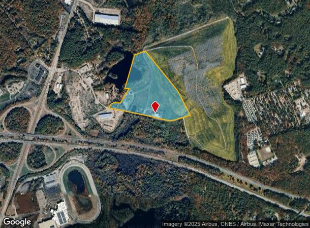
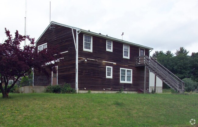
Property Record
14 Belcher St, Plainville, MA 02762

NEARBY LISTINGS FOR SALE OR LEASE
Property Detail
14 Belcher St
PLAI-000001-000000-000043F
Norfolk
Industrialgeneral
Massachusetts
AE
43f
25021C0341E
38.70 AC
2025
I-95 Corridor South
2025
Boston
440101
Boston-Cambridge-Newton, MA-NH
DEMOGRAPHICS near 14 Belcher St
1 Mile
3 Mile
5 Mile
2024 Total Population
1,658
23,471
81,484
2029 Population
1,673
23,356
81,054
Pop Growth 2024-2029
+ 0.90%
(0.49%)
(0.53%)
Average Age
44
42
41
2024 Total Households
670
9,291
31,695
HH Growth 2024-2029
+ 1.04%
(0.54%)
(0.59%)
Median Household Inc
$122,255
$118,499
$107,208
Avg Household Size
2.40
2.50
2.50
2024 Avg HH Vehicles
2.00
2.00
2.00
Median Home Value
$536,364
$524,037
$488,422
Median Year Built
1976
1978
1975
Nearby Places
Map Layers
Map Styles
 Street
 Aerial
- Restaurants
- Banks
- Shops
- Fitness
- Groceries
PUBLIC TRANSPORTATION
COMMUTER RAIL
Foxboro (Special Events Only) (Foxboro Line (Special Events Only) - Massachusetts Bay Transportation Authority Commuter Rail (Purple Line))
DRIVE
WALK
Distance
Foxboro (Special Events Only) (Foxboro Line (Special Events Only) - Massachusetts Bay Transportation Authority Commuter Rail (Purple Line))
10 min
5.1 mi
Norfolk (Franklin Line - Massachusetts Bay Transportation Authority Commuter Rail (Purple Line))
DRIVE
WALK
Distance
Norfolk (Franklin Line - Massachusetts Bay Transportation Authority Commuter Rail (Purple Line))
12 min
7.3 mi
AIRPORT
Rhode Island Tf Green International
DRIVE
WALK
Distance
Rhode Island Tf Green International
47 min
30.0 mi
General Edward Lawrence Logan International
DRIVE
WALK
Distance
General Edward Lawrence Logan International
51 min
30.8 mi
Worcester Regional
DRIVE
WALK
Distance
Worcester Regional
61 min
42.3 mi
Freight Ports
Port of Boston
DRIVE
WALK
Distance
Port of Boston
49 min
28.7 mi
Nearby Properties
Address
Land Use
TOTAL SIZE
Lot Size
Zoning
Address
Land Use
TOTAL SIZE
Lot Size
Zoning
52,064 SF
87.51 AC
CI
Address
Land Use
TOTAL SIZE
Lot Size
Zoning
204,502 SF
40.65 AC
Address
Land Use
TOTAL SIZE
Lot Size
Zoning
17.60 AC
Address
Land Use
TOTAL SIZE
Lot Size
Zoning
96,596 SF
17.01 AC
C-2 80
Address
Land Use
TOTAL SIZE
Lot Size
Zoning
231,487 SF
33.15 AC
R-30
Address
Land Use
TOTAL SIZE
Lot Size
Zoning
5,022 SF
22.90 AC
RB
Address
Land Use
TOTAL SIZE
Lot Size
Zoning
25.68 AC
Address
Land Use
TOTAL SIZE
Lot Size
Zoning
13.93 AC
CB
Address
Land Use
TOTAL SIZE
Lot Size
Zoning
350,067 SF
20.20 AC
Address
Land Use
TOTAL SIZE
Lot Size
Zoning
19,742 SF
58.34 AC
R-43
Address
Land Use
TOTAL SIZE
Lot Size
Zoning
442,756 SF
31.18 AC
Address
Land Use
TOTAL SIZE
Lot Size
Zoning
202,987 SF
25.95 AC
Address
Land Use
TOTAL SIZE
Lot Size
Zoning
86,116 SF
22.50 AC
Address
Land Use
TOTAL SIZE
Lot Size
Zoning
28.55 AC
CC
Address
Land Use
TOTAL SIZE
Lot Size
Zoning
174,103 SF
12.40 AC
Address
Land Use
TOTAL SIZE
Lot Size
Zoning
176,269 SF
40.56 AC
B-2 80
Address
Land Use
TOTAL SIZE
Lot Size
Zoning
142,040 SF
18.16 AC
CI
Address
Land Use
TOTAL SIZE
Lot Size
Zoning
113,750 SF
10.50 AC
Address
Land Use
TOTAL SIZE
Lot Size
Zoning
22 AC
CI
Address
Land Use
TOTAL SIZE
Lot Size
Zoning
93,685 SF
8 AC
Address
Land Use
TOTAL SIZE
Lot Size
Zoning
105,166 SF
5.93 AC
Address
Land Use
TOTAL SIZE
Lot Size
Zoning
79,322 SF
12.54 AC
R15
Address
Land Use
TOTAL SIZE
Lot Size
Zoning
186,200 SF
20.27 AC
Address
Land Use
TOTAL SIZE
Lot Size
Zoning
24.29 AC
Address
Land Use
TOTAL SIZE
Lot Size
Zoning
74,159 SF
4.21 AC
Address
Land Use
TOTAL SIZE
Lot Size
Zoning
89,052 SF
17 AC
Address
Land Use
TOTAL SIZE
Lot Size
Zoning
124,840 SF
10.47 AC
Address
Land Use
TOTAL SIZE
Lot Size
Zoning
72,331 SF
22.50 AC
Address
Land Use
TOTAL SIZE
Lot Size
Zoning
164,823 SF
9.61 AC
Address
Land Use
TOTAL SIZE
Lot Size
Zoning
10,984 SF
8.52 AC
B-1 10
The World's #1 Commercial Real Estate Marketplace
Connect with us
© 2025 CoStar Group
The information above has been obtained from sources believed reliable. While we do not doubt its accuracy we have not verified it and make no guarantee, warranty or representation about it. It is your responsibility to independently confirm its accuracy and completeness. Any projections, opinions, assumptions, or estimates used are for example only and do not represent the current or future performance of the property. The value of this transaction to you depends on tax and other factors which should be evaluated by your tax, financial, and legal advisors. You and your advisors should conduct a careful, independent investigation of the property to determine to your satisfaction the suitability of the property for your needs.