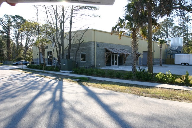
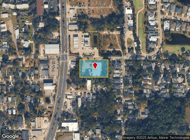
Property Record
14 Dutton Island Rd E, Atlantic Beach, FL 32233
NEARBY LISTINGS FOR SALE OR LEASE
Property Detail
14 Dutton Island Rd E
172162-0010
Donners R/P
Lightindustrial
19-16 17-2S-29E 1.37 DONNERS R/P BLK 8, E 40FT BLK 23
X
Duval
12031C0408J
Florida
2025
1.34 AC
2026
Beaches
013906
Jacksonville (Florida)
16,480 SF
Jacksonville, FL
DEMOGRAPHICS near 14 Dutton Island Rd E
1 mile
3 mile
5 mile
2024 Total Population
12,923
49,213
109,991
2029 Population
13,515
51,778
114,983
Pop Growth 2024-2029
+ 4.58%
+ 5.21%
+ 4.54%
Average Age
44
41
40
2024 Total Households
5,701
20,429
44,682
HH Growth 2024-2029
+ 4.88%
+ 5.38%
+ 4.77%
Median Household Inc
$82,729
$86,901
$89,303
Avg Household Size
2.20
2.30
2.40
2024 Avg HH Vehicles
2.00
2.00
2.00
Median Home Value
$386,335
$425,052
$370,762
Median Year Built
1983
1985
1990
Nearby Places
Map Layers
Map Styles
 Street
 Aerial
Transit
 Traffic
 Biking
Places
Listings with unknown addresses are not visible on the map
- Restaurants
- Banks
- Shops
- Fitness
- Groceries
PUBLIC TRANSPORTATION
AIRPORT
Jacksonville International
Drive
Walk
Distance
Jacksonville International
40 min
25.2 mi
Freight Ports
Jacksonville Port
Drive
Walk
Distance
Jacksonville Port
32 min
17.3 mi
Nearby Properties
Address
Land Use
TOTAL SIZE
Lot Size
Zoning
Address
Land Use
TOTAL SIZE
Lot Size
Zoning
240,363 SF
24.71 AC
PUD
Address
Land Use
TOTAL SIZE
Lot Size
Zoning
377,617 SF
23.38 AC
PUD
Address
Land Use
TOTAL SIZE
Lot Size
Zoning
178,884 SF
12.54 AC
PUD
Address
Land Use
TOTAL SIZE
Lot Size
Zoning
194,953 SF
22.43 AC
PUD
Address
Land Use
TOTAL SIZE
Lot Size
Zoning
696,126 SF
70.05 AC
APUD
Address
Land Use
TOTAL SIZE
Lot Size
Zoning
389,030 SF
26.39 AC
PUD
Address
Land Use
TOTAL SIZE
Lot Size
Zoning
34,612 SF
446.76 AC
PBF-1
Address
Land Use
TOTAL SIZE
Lot Size
Zoning
50,124 SF
2.53 AC
JRM-2
Address
Land Use
TOTAL SIZE
Lot Size
Zoning
65,384 SF
2.33 AC
ACG
Address
Land Use
TOTAL SIZE
Lot Size
Zoning
244,454 SF
14.76 AC
NR-5
Address
Land Use
TOTAL SIZE
Lot Size
Zoning
265,386 SF
29.35 AC
RMD-C
Address
Land Use
TOTAL SIZE
Lot Size
Zoning
44,526 SF
1.98 AC
JRM-2
Address
Land Use
TOTAL SIZE
Lot Size
Zoning
206,990 SF
15.79 AC
RMD-D
Address
Land Use
TOTAL SIZE
Lot Size
Zoning
185,402 SF
14.03 AC
RMD-C
Address
Land Use
TOTAL SIZE
Lot Size
Zoning
171,440 SF
11.14 AC
PUD
Address
Land Use
TOTAL SIZE
Lot Size
Zoning
157,942 SF
15.55 AC
PUD
Address
Land Use
TOTAL SIZE
Lot Size
Zoning
219,659 SF
21.37 AC
NR-1
Address
Land Use
TOTAL SIZE
Lot Size
Zoning
167,476 SF
12.89 AC
RMD-C
Address
Land Use
TOTAL SIZE
Lot Size
Zoning
120,233 SF
14.08 AC
ACG
Address
Land Use
TOTAL SIZE
Lot Size
Zoning
248,601 SF
43.01 AC
PBF-1
Address
Land Use
TOTAL SIZE
Lot Size
Zoning
151,117 SF
10.04 AC
RMD-C
Address
Land Use
TOTAL SIZE
Lot Size
Zoning
94,836 SF
12.13 AC
PUD
Address
Land Use
TOTAL SIZE
Lot Size
Zoning
95,879 SF
14.46 AC
PUD
Address
Land Use
TOTAL SIZE
Lot Size
Zoning
17.79 AC
JRS-1
Address
Land Use
TOTAL SIZE
Lot Size
Zoning
100,039 SF
6.30 AC
ARG-M
Address
Land Use
TOTAL SIZE
Lot Size
Zoning
110,902 SF
8.15 AC
RMD-C
Address
Land Use
TOTAL SIZE
Lot Size
Zoning
55,659 SF
6.91 AC
PUD
Address
Land Use
TOTAL SIZE
Lot Size
Zoning
80,746 SF
11.68 AC
NC-3
Address
Land Use
TOTAL SIZE
Lot Size
Zoning
123,803 SF
11.87 AC
PUD
Address
Land Use
TOTAL SIZE
Lot Size
Zoning
98,393 SF
6.50 AC
RMD-C
The World's #1 Commercial Real Estate Marketplace
Connect with us
© 2026 CoStar Group
The information above has been obtained from sources believed reliable. While we do not doubt its accuracy we have not verified it and make no guarantee, warranty or representation about it. It is your responsibility to independently confirm its accuracy and completeness. Any projections, opinions, assumptions, or estimates used are for example only and do not represent the current or future performance of the property. The value of this transaction to you depends on tax and other factors which should be evaluated by your tax, financial, and legal advisors. You and your advisors should conduct a careful, independent investigation of the property to determine to your satisfaction the suitability of the property for your needs.