Property Record
14 E High St, Clayton, NJ 08312
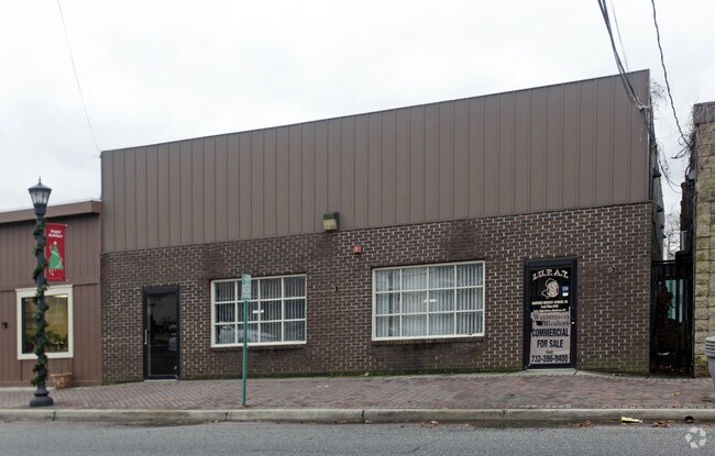

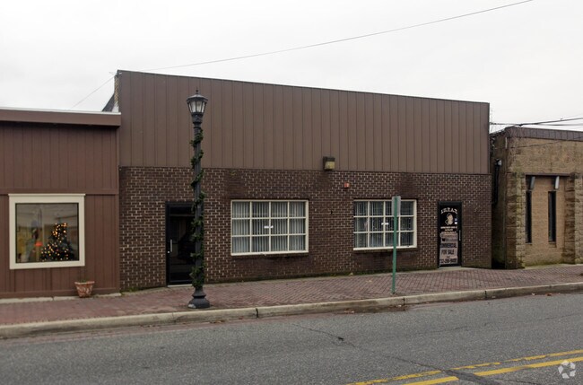
Property Detail
14 E High St
06-00045-0000-00031
Gloucester
Officebuilding
New Jersey
C2
31
B and X Area of moderate flood hazard, usually the area between the limits of the 100-year and 500-year floods.
0.12 AC
2024
Gloucester County
2025
Philadelphia
501402
Philadelphia-Camden-Wilmington, PA-NJ-DE-MD
4,640 SF
NEARBY LISTINGS FOR SALE OR LEASE
DEMOGRAPHICS near 14 E High St
1 mile
3 mile
5 mile
2025 Total Population
15,909
50,815
103,645
2030 Population
16,705
52,634
107,052
Pop Growth 2025-2030
+ 5.00%
+ 3.58%
+ 3.29%
Average Age
31
38
40
2025 Total Households
3,956
17,206
36,257
HH Growth 2025-2030
+ 7.28%
+ 3.99%
+ 3.52%
Median Household Inc
$67,434
$89,739
$98,639
Avg Household Size
2.40
2.50
2.60
2025 Avg HH Vehicles
2.00
2.00
2.00
Median Home Value
$248,752
$308,397
$334,721
Median Year Built
1979
1979
1982
Nearby Places
Map Layers
Map Styles
 Street
 Aerial
Transit
 Traffic
 Biking
Places
Listings with unknown addresses are not visible on the map
- Restaurants
- Banks
- Shops
- Fitness
- Groceries
PUBLIC TRANSPORTATION
AIRPORT
Philadelphia International
Drive
Walk
Distance
Philadelphia International
45 min
27.9 mi
Atlantic City International
Drive
Walk
Distance
Atlantic City International
73 min
40.5 mi
Freight Ports
Broadway Terminal - Pier 5
Drive
Walk
Distance
Broadway Terminal - Pier 5
29 min
19.4 mi
SALE & LEASE HISTORY
LISTING DATE
SALE/LEASE

Aug 20, 2024
For Sale
Nearby Properties
Address
Land Use
TOTAL SIZE
Lot Size
Zoning
Address
Land Use
TOTAL SIZE
Lot Size
Zoning
23.80 AC
R-B
Address
Land Use
TOTAL SIZE
Lot Size
Zoning
37.40 AC
CF/I
Address
Land Use
TOTAL SIZE
Lot Size
Zoning
17.02 AC
PA
Address
Land Use
TOTAL SIZE
Lot Size
Zoning
21.14 AC
CF/I
Address
Land Use
TOTAL SIZE
Lot Size
Zoning
76.57 AC
I
Address
Land Use
TOTAL SIZE
Lot Size
Zoning
15.47 AC
C5
Address
Land Use
TOTAL SIZE
Lot Size
Zoning
55.88 AC
APA
Address
Land Use
TOTAL SIZE
Lot Size
Zoning
3,750 SF
5.55 AC
C3
Address
Land Use
TOTAL SIZE
Lot Size
Zoning
7.61 AC
APA
Address
Land Use
TOTAL SIZE
Lot Size
Zoning
18,135 SF
6.06 AC
RE
Address
Land Use
TOTAL SIZE
Lot Size
Zoning
469 AC
CF/I
Address
Land Use
TOTAL SIZE
Lot Size
Zoning
3.11 AC
FV
Address
Land Use
TOTAL SIZE
Lot Size
Zoning
340.56 AC
CF/I
Address
Land Use
TOTAL SIZE
Lot Size
Zoning
1.99 AC
CO
Address
Land Use
TOTAL SIZE
Lot Size
Zoning
5.71 AC
C4
Address
Land Use
TOTAL SIZE
Lot Size
Zoning
176.06 AC
P
Address
Land Use
TOTAL SIZE
Lot Size
Zoning
1.99 AC
I
Address
Land Use
TOTAL SIZE
Lot Size
Zoning
10,296 SF
26.87 AC
C4
Address
Land Use
TOTAL SIZE
Lot Size
Zoning
2.51 AC
I1
Address
Land Use
TOTAL SIZE
Lot Size
Zoning
1,669 SF
3.13 AC
C-1
Address
Land Use
TOTAL SIZE
Lot Size
Zoning
5.68 AC
R5
Address
Land Use
TOTAL SIZE
Lot Size
Zoning
4,096 SF
8.86 AC
CO
Address
Land Use
TOTAL SIZE
Lot Size
Zoning
148.41 AC
P
Address
Land Use
TOTAL SIZE
Lot Size
Zoning
36.54 AC
P
Address
Land Use
TOTAL SIZE
Lot Size
Zoning
137.40 AC
P
Address
Land Use
TOTAL SIZE
Lot Size
Zoning
4,732 SF
3.04 AC
FV
Address
Land Use
TOTAL SIZE
Lot Size
Zoning
136.65 AC
P
Address
Land Use
TOTAL SIZE
Lot Size
Zoning
1,495 SF
2.01 AC
CO
Address
Land Use
TOTAL SIZE
Lot Size
Zoning
8.62 AC
C5
Address
Land Use
TOTAL SIZE
Lot Size
Zoning
3.13 AC
P
The World's #1 Commercial Real Estate Marketplace
Connect with us
© 2026 CoStar Group
The information above has been obtained from sources believed reliable. While we do not doubt its accuracy we have not verified it and make no guarantee, warranty or representation about it. It is your responsibility to independently confirm its accuracy and completeness. Any projections, opinions, assumptions, or estimates used are for example only and do not represent the current or future performance of the property. The value of this transaction to you depends on tax and other factors which should be evaluated by your tax, financial, and legal advisors. You and your advisors should conduct a careful, independent investigation of the property to determine to your satisfaction the suitability of the property for your needs.