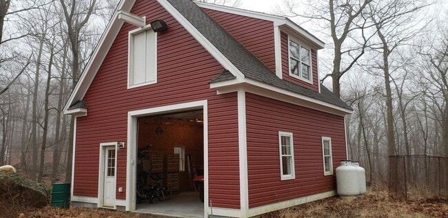
Property Record
22 Hardscrabble Rd, Sherman, CT 06784

Current Lease Availabilities
NEARBY LISTINGS FOR SALE OR LEASE
-
-
View all Sherman listings for lease on LoopNet.com
Property Detail
22 Hardscrabble Rd
SHMN-000001-000000-000011
Fairfield
Residentialacreage
Connecticut
X
1.86 AC
36079C0069E
Danbury
2024
Westchester/So Connecticut
2025
Bridgeport-Stamford-Danbury, CT
257100
DEMOGRAPHICS near 22 Hardscrabble Rd
1 mile
3 mile
5 mile
2024 Total Population
227
5,467
28,284
2029 Population
230
5,554
28,653
Pop Growth 2024-2029
+ 1.32%
+ 1.59%
+ 1.30%
Average Age
45
44
44
2024 Total Households
80
1,885
10,406
HH Growth 2024-2029
+ 1.25%
+ 1.75%
+ 1.38%
Median Household Inc
$113,749
$110,519
$111,473
Avg Household Size
2.60
2.60
2.60
2024 Avg HH Vehicles
2.00
2.00
2.00
Median Home Value
$483,333
$443,750
$390,125
Median Year Built
1979
1970
1967
Nearby Places
Map Layers
Map Styles
 Street
 Aerial
Transit
 Traffic
 Biking
Places
Listings with unknown addresses are not visible on the map
- Restaurants
- Banks
- Shops
- Fitness
- Groceries
PUBLIC TRANSPORTATION
COMMUTER RAIL
Pawling Station (Harlem Line - Metro-North Commuter Railroad Company (Metro-North))
Drive
Walk
Distance
Pawling Station (Harlem Line - Metro-North Commuter Railroad Company (Metro-North))
21 min
6.5 mi
Patterson Station (Harlem Line - Metro-North Commuter Railroad Company (Metro-North))
Drive
Walk
Distance
Patterson Station (Harlem Line - Metro-North Commuter Railroad Company (Metro-North))
15 min
8.1 mi
AIRPORT
New York Stewart International
Drive
Walk
Distance
New York Stewart International
60 min
40.1 mi
Freight Ports
Port of New Haven
Drive
Walk
Distance
Port of New Haven
73 min
46.5 mi
Nearby Properties
Address
Land Use
TOTAL SIZE
Lot Size
Zoning
Address
Land Use
TOTAL SIZE
Lot Size
Zoning
4,241 SF
151.46 AC
R4
Address
Land Use
TOTAL SIZE
Lot Size
Zoning
5,070 SF
76 AC
CD-R5
Address
Land Use
TOTAL SIZE
Lot Size
Zoning
604.69 AC
R4
Address
Land Use
TOTAL SIZE
Lot Size
Zoning
5,171 SF
168.99 AC
Address
Land Use
TOTAL SIZE
Lot Size
Zoning
3,232 SF
10.90 AC
CD-R5
Address
Land Use
TOTAL SIZE
Lot Size
Zoning
261.39 AC
R4
Address
Land Use
TOTAL SIZE
Lot Size
Zoning
4,796 SF
2.03 AC
2
Address
Land Use
TOTAL SIZE
Lot Size
Zoning
759 SF
46.80 AC
Address
Land Use
TOTAL SIZE
Lot Size
Zoning
96.55 AC
R4
Address
Land Use
TOTAL SIZE
Lot Size
Zoning
237.25 AC
R4
Address
Land Use
TOTAL SIZE
Lot Size
Zoning
470.15 AC
2
Address
Land Use
TOTAL SIZE
Lot Size
Zoning
7,615 SF
9.20 AC
2
Address
Land Use
TOTAL SIZE
Lot Size
Zoning
106 AC
2
Address
Land Use
TOTAL SIZE
Lot Size
Zoning
4,480 SF
36.78 AC
Address
Land Use
TOTAL SIZE
Lot Size
Zoning
9,513 SF
40.51 AC
CD-R5
Address
Land Use
TOTAL SIZE
Lot Size
Zoning
5,159 SF
11.41 AC
R4
Address
Land Use
TOTAL SIZE
Lot Size
Zoning
5,008 SF
310.43 AC
CD-R5
Address
Land Use
TOTAL SIZE
Lot Size
Zoning
10,359 SF
23.02 AC
R4
Address
Land Use
TOTAL SIZE
Lot Size
Zoning
6,710 SF
18.37 AC
R4
Address
Land Use
TOTAL SIZE
Lot Size
Zoning
5,751 SF
55.30 AC
R4
Address
Land Use
TOTAL SIZE
Lot Size
Zoning
6,749 SF
63.60 AC
CD-R5
Address
Land Use
TOTAL SIZE
Lot Size
Zoning
1.75 AC
1
Address
Land Use
TOTAL SIZE
Lot Size
Zoning
6,450 SF
11.19 AC
R4
Address
Land Use
TOTAL SIZE
Lot Size
Zoning
4,444 SF
2.10 AC
2
Address
Land Use
TOTAL SIZE
Lot Size
Zoning
4,749 SF
10.87 AC
R4
Address
Land Use
TOTAL SIZE
Lot Size
Zoning
5,765 SF
24.45 AC
R4
Address
Land Use
TOTAL SIZE
Lot Size
Zoning
5,041 SF
79.58 AC
R4
Address
Land Use
TOTAL SIZE
Lot Size
Zoning
6,299 SF
2.04 AC
2
Address
Land Use
TOTAL SIZE
Lot Size
Zoning
144.19 AC
R4
Address
Land Use
TOTAL SIZE
Lot Size
Zoning
8,243 SF
7.76 AC
R4
The World's #1 Commercial Real Estate Marketplace
Connect with us
© 2026 CoStar Group
The information above has been obtained from sources believed reliable. While we do not doubt its accuracy we have not verified it and make no guarantee, warranty or representation about it. It is your responsibility to independently confirm its accuracy and completeness. Any projections, opinions, assumptions, or estimates used are for example only and do not represent the current or future performance of the property. The value of this transaction to you depends on tax and other factors which should be evaluated by your tax, financial, and legal advisors. You and your advisors should conduct a careful, independent investigation of the property to determine to your satisfaction the suitability of the property for your needs.