Property Record
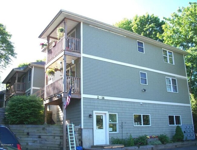
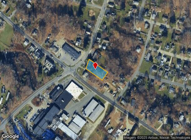
14 Highland Ave, Pittsfield, MA 01201
This Property Is For Sale
NEARBY LISTINGS FOR SALE OR LEASE
Property Detail
14 Highland Ave
Pittsfield, MA
Westside Park
PITT-000013F-000004-000023
Berkshire
Apartment
Massachusetts
2025
23
2025
0.41 AC
900400
Massachusetts North/West Area
8,608 SF
Other Market Areas
DEMOGRAPHICS near 14 Highland Ave
1 Mile
3 Mile
5 Mile
2024 Total Population
4,415
34,220
48,181
2029 Population
4,367
33,718
47,443
Pop Growth 2024-2029
(1.09%)
(1.47%)
(1.53%)
Average Age
44
43
44
2024 Total Households
1,907
15,487
21,485
HH Growth 2024-2029
(1.15%)
(1.53%)
(1.61%)
Median Household Inc
$65,934
$52,880
$59,093
Avg Household Size
2.20
2.10
2.10
2024 Avg HH Vehicles
2.00
1.00
2.00
Median Home Value
$187,586
$198,084
$221,546
Median Year Built
1957
1948
1950
Nearby Places
- Restaurants
- Banks
- Shops
- Fitness
- Groceries
PUBLIC TRANSPORTATION
COMMUTER RAIL
Pittsfield Amtrak Station (Empire Service - Amtrak, Lake Shore Limited - Amtrak)
DRIVE
WALK
Distance
Pittsfield Amtrak Station (Empire Service - Amtrak, Lake Shore Limited - Amtrak)
5 min
2.1 mi
Freight Ports
Albany, NY Port
DRIVE
WALK
Distance
Albany, NY Port
65 min
41.3 mi
Nearby Properties
Address
Land Use
TOTAL SIZE
Lot Size
Zoning
Address
Land Use
TOTAL SIZE
Lot Size
Zoning
8.36 AC
BG
Address
Land Use
TOTAL SIZE
Lot Size
Zoning
363,252 SF
50 AC
R20
Address
Land Use
TOTAL SIZE
Lot Size
Zoning
600 SF
19.89 AC
R20
Address
Land Use
TOTAL SIZE
Lot Size
Zoning
284,301 SF
8.70 AC
DCD
Address
Land Use
TOTAL SIZE
Lot Size
Zoning
31.73 AC
R20
Address
Land Use
TOTAL SIZE
Lot Size
Zoning
81 AC
R43
Address
Land Use
TOTAL SIZE
Lot Size
Zoning
Address
Land Use
TOTAL SIZE
Lot Size
Zoning
6.15 AC
IG
Address
Land Use
TOTAL SIZE
Lot Size
Zoning
165,400 SF
0.49 AC
IG
Address
Land Use
TOTAL SIZE
Lot Size
Zoning
334,640 SF
2.41 AC
DCD
Address
Land Use
TOTAL SIZE
Lot Size
Zoning
237.50 AC
R6
Address
Land Use
TOTAL SIZE
Lot Size
Zoning
130,904 SF
10.02 AC
R20
Address
Land Use
TOTAL SIZE
Lot Size
Zoning
41,395 SF
0.98 AC
BG
Address
Land Use
TOTAL SIZE
Lot Size
Zoning
82,292 SF
37.50 AC
R6
Address
Land Use
TOTAL SIZE
Lot Size
Zoning
2.38 AC
DCD
Address
Land Use
TOTAL SIZE
Lot Size
Zoning
1.30 AC
DCD
Address
Land Use
TOTAL SIZE
Lot Size
Zoning
29,700 SF
0.56 AC
DCD
Address
Land Use
TOTAL SIZE
Lot Size
Zoning
124,490 SF
8.22 AC
B
Address
Land Use
TOTAL SIZE
Lot Size
Zoning
15 AC
R20
Address
Land Use
TOTAL SIZE
Lot Size
Zoning
37,551 SF
6.50 AC
R6
Address
Land Use
TOTAL SIZE
Lot Size
Zoning
49,209 SF
2.66 AC
RM
Address
Land Use
TOTAL SIZE
Lot Size
Zoning
225,775 SF
1.57 AC
BG
Address
Land Use
TOTAL SIZE
Lot Size
Zoning
82,160 SF
5.40 AC
RM
Address
Land Use
TOTAL SIZE
Lot Size
Zoning
1,598 AC
R
Address
Land Use
TOTAL SIZE
Lot Size
Zoning
34 AC
R20
Address
Land Use
TOTAL SIZE
Lot Size
Zoning
35 AC
RG
Address
Land Use
TOTAL SIZE
Lot Size
Zoning
106,353 SF
0.91 AC
DCD
Address
Land Use
TOTAL SIZE
Lot Size
Zoning
6.30 AC
RM
Address
Land Use
TOTAL SIZE
Lot Size
Zoning
74,460 SF
0.74 AC
DCD
Address
Land Use
TOTAL SIZE
Lot Size
Zoning
60.30 AC
IG
The World's #1 Commercial Real Estate Marketplace
Connect with us
© 2025 CoStar Group
The information above has been obtained from sources believed reliable. While we do not doubt its accuracy we have not verified it and make no guarantee, warranty or representation about it. It is your responsibility to independently confirm its accuracy and completeness. Any projections, opinions, assumptions, or estimates used are for example only and do not represent the current or future performance of the property. The value of this transaction to you depends on tax and other factors which should be evaluated by your tax, financial, and legal advisors. You and your advisors should conduct a careful, independent investigation of the property to determine to your satisfaction the suitability of the property for your needs.