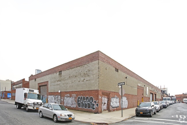
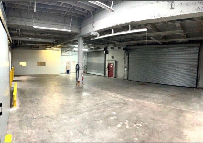
Property Record
14 Meserole Ave, Brooklyn, NY 11222


Property Detail
14 Meserole Ave
02615-0001
DOCID-2018122701286001ADDL BLK-LOT: 2615-50
Heavyindustrial
KINGS
M1-5
New York
AE The base floodplain where base flood elevations are provided. AE Zones are now used on new format FIRMs instead of A1-A30 Zones.
1
2025
0.45 AC
2026
North Brooklyn
057300
Long Island (New York)
21,275 SF
New York-Jersey City-White Plains, NY-NJ
NEARBY LISTINGS FOR SALE OR LEASE
DEMOGRAPHICS near 14 Meserole Ave
1 mile
3 mile
5 mile
2025 Total Population
99,578
1,401,730
3,302,275
2030 Population
101,879
1,448,127
3,378,367
Pop Growth 2025-2030
+ 2.31%
+ 3.31%
+ 2.30%
Average Age
37
39
40
2025 Total Households
47,796
640,160
1,440,501
HH Growth 2025-2030
+ 1.98%
+ 3.64%
+ 2.71%
Median Household Inc
$145,926
$111,144
$106,712
Avg Household Size
2.00
2.10
2.20
2025 Avg HH Vehicles
.00
.00
.00
Median Home Value
$1,085,862
$1,000,647
$971,981
Median Year Built
1962
1956
1953
Nearby Places
Map Layers
Map Styles
 Street
 Aerial
Layers
 Traffic
 Biking
Places
Listings with unknown addresses are not visible on the map
- Restaurants
- Banks
- Shops
- Fitness
- Groceries
PUBLIC TRANSPORTATION
TRANSIT/SUBWAY
Nassau Avenue (G - New York MTA Subway (The Subway))
Drive
Walk
Distance
Nassau Avenue (G - New York MTA Subway (The Subway))
2 min
7 min
0.4 mi
Greenpoint Avenue (G - New York MTA Subway (The Subway))
Drive
Walk
Distance
Greenpoint Avenue (G - New York MTA Subway (The Subway))
2 min
10 min
0.5 mi
Bedford Avenue (L - New York MTA Subway (The Subway))
Drive
Walk
Distance
Bedford Avenue (L - New York MTA Subway (The Subway))
3 min
14 min
0.8 mi
Lorimer Street (L Line) (L - New York MTA Subway (The Subway))
Drive
Walk
Distance
Lorimer Street (L Line) (L - New York MTA Subway (The Subway))
4 min
20 min
1.1 mi
Metropolitan Avenue (G - New York MTA Subway (The Subway))
Drive
Walk
Distance
Metropolitan Avenue (G - New York MTA Subway (The Subway))
3 min
20 min
1.1 mi
COMMUTER RAIL
Hunterspoint Avenue Station (Hempstead Branch - Long Island Rail Road, Oyster Bay Branch - Long Island Rail Road)
Drive
Walk
Distance
Hunterspoint Avenue Station (Hempstead Branch - Long Island Rail Road, Oyster Bay Branch - Long Island Rail Road)
5 min
1.7 mi
Long Island City Station (Hempstead Branch - Long Island Rail Road)
Drive
Walk
Distance
Long Island City Station (Hempstead Branch - Long Island Rail Road)
6 min
2.0 mi
AIRPORT
LaGuardia
Drive
Walk
Distance
LaGuardia
16 min
7.3 mi
John F Kennedy International
Drive
Walk
Distance
John F Kennedy International
25 min
15.2 mi
Newark Liberty International
Drive
Walk
Distance
Newark Liberty International
29 min
15.8 mi
Freight Ports
NY - Red Hook Container Terminal
Drive
Walk
Distance
NY - Red Hook Container Terminal
12 min
5.7 mi
SALE & LEASE HISTORY
LISTING DATE
SALE/LEASE

Jan 19, 2022
For Lease
Nearby Properties
Address
Land Use
TOTAL SIZE
Lot Size
Zoning
Address
Land Use
TOTAL SIZE
Lot Size
Zoning
2,245,112 SF
2.02 AC
C6-6
Address
Land Use
TOTAL SIZE
Lot Size
Zoning
1,783,434 SF
1.94 AC
C5-3
Address
Land Use
TOTAL SIZE
Lot Size
Zoning
2,521,850 SF
1.59 AC
C6-4
Address
Land Use
TOTAL SIZE
Lot Size
Zoning
8,462,176 SF
61.41 AC
R7-2
Address
Land Use
TOTAL SIZE
Lot Size
Zoning
2,050,615 SF
1.84 AC
C5-3
Address
Land Use
TOTAL SIZE
Lot Size
Zoning
940,000 SF
1.44 AC
C6-2
Address
Land Use
TOTAL SIZE
Lot Size
Zoning
2,636,182 SF
2.35 AC
C65.5
Address
Land Use
TOTAL SIZE
Lot Size
Zoning
2,161,994 SF
3.79 AC
M1-5
Address
Land Use
TOTAL SIZE
Lot Size
Zoning
1,678,135 SF
1.01 AC
C5-3
Address
Land Use
TOTAL SIZE
Lot Size
Zoning
2,354,289 SF
3.96 AC
C6-4
Address
Land Use
TOTAL SIZE
Lot Size
Zoning
2,812,739 SF
2.10 AC
C5-3
Address
Land Use
TOTAL SIZE
Lot Size
Zoning
1,642,675 SF
1.05 AC
C6-7
Address
Land Use
TOTAL SIZE
Lot Size
Zoning
2,734,038 SF
4.24 AC
C52.5
Address
Land Use
TOTAL SIZE
Lot Size
Zoning
1,897,491 SF
2.06 AC
C52.5
Address
Land Use
TOTAL SIZE
Lot Size
Zoning
1,638,259 SF
1.43 AC
C52.5
Address
Land Use
TOTAL SIZE
Lot Size
Zoning
2,360,627 SF
2.08 AC
C6-7
Address
Land Use
TOTAL SIZE
Lot Size
Zoning
1,984,228 SF
1.95 AC
C65.5
Address
Land Use
TOTAL SIZE
Lot Size
Zoning
1,962,900 SF
1.89 AC
C66.5
Address
Land Use
TOTAL SIZE
Lot Size
Zoning
1,048,620 SF
5.67 AC
C6-4
Address
Land Use
TOTAL SIZE
Lot Size
Zoning
1,946,157 SF
1.49 AC
C6-4
Address
Land Use
TOTAL SIZE
Lot Size
Zoning
1,586,876 SF
1.87 AC
C5-3
Address
Land Use
TOTAL SIZE
Lot Size
Zoning
1,842,991 SF
2.08 AC
C66.5
Address
Land Use
TOTAL SIZE
Lot Size
Zoning
1,751,641 SF
1.84 AC
C6-4
Address
Land Use
TOTAL SIZE
Lot Size
Zoning
2,535,958 SF
2.94 AC
C6-4
Address
Land Use
TOTAL SIZE
Lot Size
Zoning
1,613,847 SF
1.84 AC
C66.5
Address
Land Use
TOTAL SIZE
Lot Size
Zoning
1,596,521 SF
1.34 AC
C6-4
Address
Land Use
TOTAL SIZE
Lot Size
Zoning
1,805,894 SF
1.42 AC
C6-4
Address
Land Use
TOTAL SIZE
Lot Size
Zoning
1,448,897 SF
1.56 AC
C6-6
Address
Land Use
TOTAL SIZE
Lot Size
Zoning
2,400,000 SF
15.14 AC
C5-2
Address
Land Use
TOTAL SIZE
Lot Size
Zoning
1,649,604 SF
1.51 AC
C67T
The World's #1 Commercial Real Estate Marketplace
Connect with us
© 2026 CoStar Group
The information above has been obtained from sources believed reliable. While we do not doubt its accuracy we have not verified it and make no guarantee, warranty or representation about it. It is your responsibility to independently confirm its accuracy and completeness. Any projections, opinions, assumptions, or estimates used are for example only and do not represent the current or future performance of the property. The value of this transaction to you depends on tax and other factors which should be evaluated by your tax, financial, and legal advisors. You and your advisors should conduct a careful, independent investigation of the property to determine to your satisfaction the suitability of the property for your needs.