Property Record
14 Narragansett Ave, Jamestown, RI 02835


NEARBY LISTINGS FOR SALE OR LEASE
-
-
View all Jamestown listings for lease on LoopNet.com
Property Detail
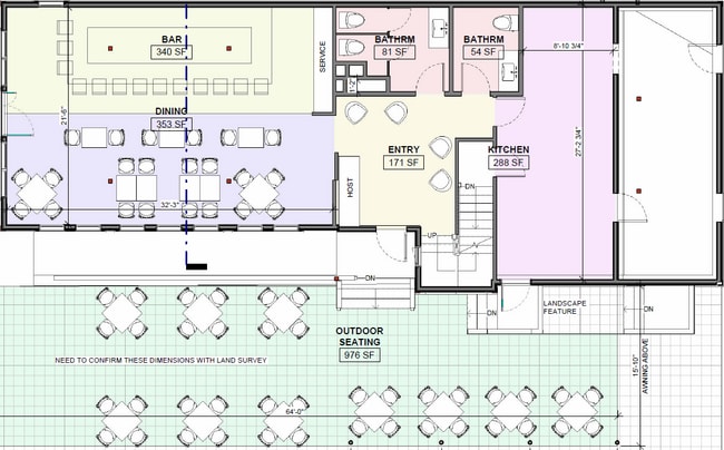
14 Narragansett Ave
JAME-000008-000000-000168
Newport
Commercialbuilding
Rhode Island
X
168
44005C0176J
0.12 AC
2025
Newport County
2025
Providence
041300
Providence-Warwick, RI-MA
2,753 SF
DEMOGRAPHICS near 14 Narragansett Ave
1 Mile
3 Mile
5 Mile
2024 Total Population
2,447
13,469
51,610
2029 Population
2,465
13,389
51,067
Pop Growth 2024-2029
+ 0.74%
(0.59%)
(1.05%)
Average Age
52
45
45
2024 Total Households
1,157
5,871
22,341
HH Growth 2024-2029
+ 0.43%
(0.70%)
(1.23%)
Median Household Inc
$87,080
$78,546
$87,440
Avg Household Size
2.10
2.10
2.10
2024 Avg HH Vehicles
2.00
2.00
2.00
Median Home Value
$925,904
$785,878
$607,170
Median Year Built
1965
1957
1961
Nearby Places
Map Layers
Map Styles
 Street
 Aerial
- Restaurants
- Banks
- Shops
- Fitness
- Groceries
PUBLIC TRANSPORTATION
AIRPORT
Rhode Island Tf Green International
DRIVE
WALK
Distance
Rhode Island Tf Green International
41 min
25.4 mi
SALE & LEASE HISTORY
LISTING DATE
SALE/LEASE

Mar 07, 2024
For Sale
Jul 23, 2024
For Lease
Apr 01, 2020
For Sale
Nearby Properties
Address
Land Use
TOTAL SIZE
Lot Size
Zoning
Address
Land Use
TOTAL SIZE
Lot Size
Zoning
264,032 SF
3.73 AC
GB
Address
Land Use
TOTAL SIZE
Lot Size
Zoning
237,976 SF
8.99 AC
WB
Address
Land Use
TOTAL SIZE
Lot Size
Zoning
17,739 SF
103.90 AC
P
Address
Land Use
TOTAL SIZE
Lot Size
Zoning
249,902 SF
27.88 AC
UV
Address
Land Use
TOTAL SIZE
Lot Size
Zoning
76,534 SF
5.29 AC
WB
Address
Land Use
TOTAL SIZE
Lot Size
Zoning
158,333 SF
1.81 AC
R10
Address
Land Use
TOTAL SIZE
Lot Size
Zoning
217,212 SF
10.46 AC
R10
Address
Land Use
TOTAL SIZE
Lot Size
Zoning
172,320 SF
10.14 AC
R10
Address
Land Use
TOTAL SIZE
Lot Size
Zoning
21,977 SF
36.71 AC
R120
Address
Land Use
TOTAL SIZE
Lot Size
Zoning
21.21 AC
RR20
Address
Land Use
TOTAL SIZE
Lot Size
Zoning
41,145 SF
9.33 AC
R120
Address
Land Use
TOTAL SIZE
Lot Size
Zoning
36,984 SF
10 AC
R10
Address
Land Use
TOTAL SIZE
Lot Size
Zoning
50,220 SF
8.83 AC
TM
Address
Land Use
TOTAL SIZE
Lot Size
Zoning
24 AC
R120
Address
Land Use
TOTAL SIZE
Lot Size
Zoning
45,283 SF
1.66 AC
WB
Address
Land Use
TOTAL SIZE
Lot Size
Zoning
77.46 AC
R80
Address
Land Use
TOTAL SIZE
Lot Size
Zoning
121,259 SF
6.40 AC
GB
Address
Land Use
TOTAL SIZE
Lot Size
Zoning
56,313 SF
0.53 AC
GB
Address
Land Use
TOTAL SIZE
Lot Size
Zoning
10.64 AC
P
Address
Land Use
TOTAL SIZE
Lot Size
Zoning
87,092 SF
1.46 AC
WB
Address
Land Use
TOTAL SIZE
Lot Size
Zoning
51,686 SF
2.46 AC
WB
Address
Land Use
TOTAL SIZE
Lot Size
Zoning
32,896 SF
0.55 AC
GB
Address
Land Use
TOTAL SIZE
Lot Size
Zoning
9,744 SF
15 AC
R120
Address
Land Use
TOTAL SIZE
Lot Size
Zoning
44,396 SF
0.80 AC
GB
Address
Land Use
TOTAL SIZE
Lot Size
Zoning
52.56 AC
R120
Address
Land Use
TOTAL SIZE
Lot Size
Zoning
1,929 SF
2.70 AC
R80
Address
Land Use
TOTAL SIZE
Lot Size
Zoning
43,454 SF
3.68 AC
P
Address
Land Use
TOTAL SIZE
Lot Size
Zoning
22,901 SF
139.98 AC
R160
Address
Land Use
TOTAL SIZE
Lot Size
Zoning
14,844 SF
1.75 AC
WB
Address
Land Use
TOTAL SIZE
Lot Size
Zoning
96,672 SF
2.30 AC
GB
The World's #1 Commercial Real Estate Marketplace
Connect with us
© 2025 CoStar Group
The information above has been obtained from sources believed reliable. While we do not doubt its accuracy we have not verified it and make no guarantee, warranty or representation about it. It is your responsibility to independently confirm its accuracy and completeness. Any projections, opinions, assumptions, or estimates used are for example only and do not represent the current or future performance of the property. The value of this transaction to you depends on tax and other factors which should be evaluated by your tax, financial, and legal advisors. You and your advisors should conduct a careful, independent investigation of the property to determine to your satisfaction the suitability of the property for your needs.