Property Record
14 Perry Dr, Foxboro, MA 02035

NEARBY LISTINGS FOR SALE OR LEASE
Property Detail
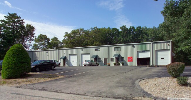
14 Perry Dr
Industrialcondominium
Norfolk
A
Massachusetts
25021C0351F
2
2025
I-95 Corridor South
2025
Boston
410400
Boston-Cambridge-Newton, MA-NH
3,200 SF
FOXB-000002-000000-005801
DEMOGRAPHICS near 14 Perry Dr
1 Mile
3 Mile
5 Mile
2024 Total Population
3,286
28,215
78,474
2029 Population
3,177
28,159
78,202
Pop Growth 2024-2029
(3.32%)
(0.20%)
(0.35%)
Average Age
39
41
41
2024 Total Households
1,158
10,603
28,719
HH Growth 2024-2029
(3.71%)
(0.15%)
(0.36%)
Median Household Inc
$135,034
$112,093
$134,828
Avg Household Size
2.70
2.60
2.70
2024 Avg HH Vehicles
2.00
2.00
2.00
Median Home Value
$681,122
$606,422
$649,517
Median Year Built
1991
1973
1974
Nearby Places
Map Layers
Map Styles
 Street
 Aerial
- Restaurants
- Banks
- Shops
- Fitness
- Groceries
PUBLIC TRANSPORTATION
COMMUTER RAIL
Foxboro (Special Events Only) (Foxboro Line (Special Events Only) - Massachusetts Bay Transportation Authority Commuter Rail (Purple Line))
DRIVE
WALK
Distance
Foxboro (Special Events Only) (Foxboro Line (Special Events Only) - Massachusetts Bay Transportation Authority Commuter Rail (Purple Line))
6 min
2.5 mi
Walpole (Foxboro Line (Special Events Only) - Massachusetts Bay Transportation Authority Commuter Rail (Purple Line), Franklin Line - Massachusetts Bay Transportation Authority Commuter Rail (Purple Line))
DRIVE
WALK
Distance
Walpole (Foxboro Line (Special Events Only) - Massachusetts Bay Transportation Authority Commuter Rail (Purple Line), Franklin Line - Massachusetts Bay Transportation Authority Commuter Rail (Purple Line))
8 min
4.1 mi
AIRPORT
General Edward Lawrence Logan International
DRIVE
WALK
Distance
General Edward Lawrence Logan International
42 min
25.2 mi
Rhode Island Tf Green International
DRIVE
WALK
Distance
Rhode Island Tf Green International
54 min
34.0 mi
Worcester Regional
DRIVE
WALK
Distance
Worcester Regional
70 min
48.4 mi
Freight Ports
Port of Boston
DRIVE
WALK
Distance
Port of Boston
40 min
23.1 mi
SALE & LEASE HISTORY
LISTING DATE
SALE/LEASE

May 07, 2020
For Lease
May 07, 2020
For Sale
Nearby Properties
Address
Land Use
TOTAL SIZE
Lot Size
Zoning
Address
Land Use
TOTAL SIZE
Lot Size
Zoning
Address
Land Use
TOTAL SIZE
Lot Size
Zoning
198,498 SF
14 AC
Address
Land Use
TOTAL SIZE
Lot Size
Zoning
205,897 SF
37.36 AC
Address
Land Use
TOTAL SIZE
Lot Size
Zoning
245,693 SF
2.57 AC
Address
Land Use
TOTAL SIZE
Lot Size
Zoning
2,385 SF
21.39 AC
Address
Land Use
TOTAL SIZE
Lot Size
Zoning
1,080 SF
10.07 AC
Address
Land Use
TOTAL SIZE
Lot Size
Zoning
211,362 SF
2.39 AC
Address
Land Use
TOTAL SIZE
Lot Size
Zoning
41.28 AC
Address
Land Use
TOTAL SIZE
Lot Size
Zoning
11.98 AC
Address
Land Use
TOTAL SIZE
Lot Size
Zoning
83,014 SF
129.67 AC
Address
Land Use
TOTAL SIZE
Lot Size
Zoning
126,484 SF
1.61 AC
Address
Land Use
TOTAL SIZE
Lot Size
Zoning
93,218 SF
9.68 AC
LI
Address
Land Use
TOTAL SIZE
Lot Size
Zoning
59,390 SF
5.69 AC
Address
Land Use
TOTAL SIZE
Lot Size
Zoning
814.08 AC
Address
Land Use
TOTAL SIZE
Lot Size
Zoning
7.86 AC
Address
Land Use
TOTAL SIZE
Lot Size
Zoning
102,024 SF
9.97 AC
LI
Address
Land Use
TOTAL SIZE
Lot Size
Zoning
147,984 SF
20.57 AC
Address
Land Use
TOTAL SIZE
Lot Size
Zoning
202,800 SF
20.33 AC
Address
Land Use
TOTAL SIZE
Lot Size
Zoning
11.97 AC
Address
Land Use
TOTAL SIZE
Lot Size
Zoning
101,171 SF
11.12 AC
LI
Address
Land Use
TOTAL SIZE
Lot Size
Zoning
109,094 SF
6.19 AC
Address
Land Use
TOTAL SIZE
Lot Size
Zoning
124,519 SF
14.22 AC
LI
Address
Land Use
TOTAL SIZE
Lot Size
Zoning
246,854 SF
31.90 AC
Address
Land Use
TOTAL SIZE
Lot Size
Zoning
80,453 SF
10.79 AC
Address
Land Use
TOTAL SIZE
Lot Size
Zoning
91,216 SF
1.18 AC
Address
Land Use
TOTAL SIZE
Lot Size
Zoning
21,796 SF
2.74 AC
Address
Land Use
TOTAL SIZE
Lot Size
Zoning
61,880 SF
6.06 AC
Address
Land Use
TOTAL SIZE
Lot Size
Zoning
46,536 SF
1.64 AC
Address
Land Use
TOTAL SIZE
Lot Size
Zoning
19,654 SF
0.20 AC
Address
Land Use
TOTAL SIZE
Lot Size
Zoning
117,428 SF
2.81 AC
The World's #1 Commercial Real Estate Marketplace
Connect with us
© 2025 CoStar Group
The information above has been obtained from sources believed reliable. While we do not doubt its accuracy we have not verified it and make no guarantee, warranty or representation about it. It is your responsibility to independently confirm its accuracy and completeness. Any projections, opinions, assumptions, or estimates used are for example only and do not represent the current or future performance of the property. The value of this transaction to you depends on tax and other factors which should be evaluated by your tax, financial, and legal advisors. You and your advisors should conduct a careful, independent investigation of the property to determine to your satisfaction the suitability of the property for your needs.