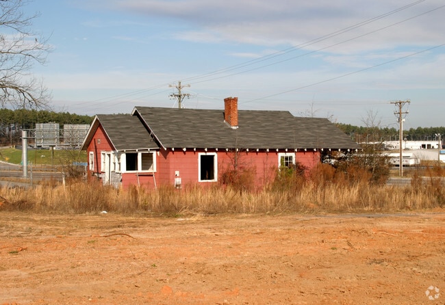
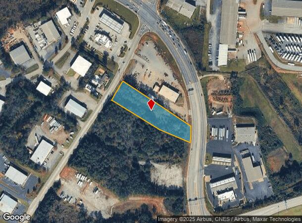
Property Record
14 S S Hwy, , SC
NEARBY LISTINGS FOR SALE OR LEASE
Property Detail
14 S S Hwy
Greenville-Anderson-Greer, SC
Survey For Christopher David Properties
0529.02-01-017.00
MAP 0529.02
Commercialnec
Greenville
X
South Carolina
45045C0426E
017.00
2025
1.70 AC
2024
Pelham/I-85
002503
Greenville/Spartanburg
917 SF
DEMOGRAPHICS near 14 S S Hwy
1 Mile
3 Mile
5 Mile
2024 Total Population
618
30,996
104,958
2029 Population
716
34,454
116,080
Pop Growth 2024-2029
+ 15.86%
+ 11.16%
+ 10.60%
Average Age
40
40
40
2024 Total Households
237
11,796
40,893
HH Growth 2024-2029
+ 16.46%
+ 11.17%
+ 10.67%
Median Household Inc
$90,046
$100,389
$82,496
Avg Household Size
2.60
2.60
2.50
2024 Avg HH Vehicles
2.00
2.00
2.00
Median Home Value
$252,808
$318,774
$286,356
Median Year Built
2010
1999
1994
Nearby Places
Map Layers
Map Styles
 Street
 Aerial
- Restaurants
- Banks
- Shops
- Fitness
- Groceries
PUBLIC TRANSPORTATION
AIRPORT
Greenville Spartanburg International
DRIVE
WALK
Distance
Greenville Spartanburg International
6 min
1.6 mi
Nearby Properties
Address
Land Use
TOTAL SIZE
Lot Size
Zoning
Address
Land Use
TOTAL SIZE
Lot Size
Zoning
18.50 AC
RS
Address
Land Use
TOTAL SIZE
Lot Size
Zoning
20.40 AC
RS
Address
Land Use
TOTAL SIZE
Lot Size
Zoning
17.53 AC
I1
Address
Land Use
TOTAL SIZE
Lot Size
Zoning
1,202 SF
14.38 AC
RS
Address
Land Use
TOTAL SIZE
Lot Size
Zoning
86,884 SF
5.31 AC
Address
Land Use
TOTAL SIZE
Lot Size
Zoning
2,417 SF
115.88 AC
Address
Land Use
TOTAL SIZE
Lot Size
Zoning
5.20 AC
TI1
Address
Land Use
TOTAL SIZE
Lot Size
Zoning
4.80 AC
I1
Address
Land Use
TOTAL SIZE
Lot Size
Zoning
136.04 AC
I1
Address
Land Use
TOTAL SIZE
Lot Size
Zoning
143.57 AC
I1
Address
Land Use
TOTAL SIZE
Lot Size
Zoning
5.80 AC
RS
Address
Land Use
TOTAL SIZE
Lot Size
Zoning
23.20 AC
PD
Address
Land Use
TOTAL SIZE
Lot Size
Zoning
92.74 AC
R15
Address
Land Use
TOTAL SIZE
Lot Size
Zoning
43.58 AC
RS
Address
Land Use
TOTAL SIZE
Lot Size
Zoning
9.90 AC
I1
Address
Land Use
TOTAL SIZE
Lot Size
Zoning
15.26 AC
Address
Land Use
TOTAL SIZE
Lot Size
Zoning
22.48 AC
I1
Address
Land Use
TOTAL SIZE
Lot Size
Zoning
9.27 AC
I1
Address
Land Use
TOTAL SIZE
Lot Size
Zoning
88.98 AC
RS
Address
Land Use
TOTAL SIZE
Lot Size
Zoning
18.50 AC
PD
Address
Land Use
TOTAL SIZE
Lot Size
Zoning
17.60 AC
PD
Address
Land Use
TOTAL SIZE
Lot Size
Zoning
2.12 AC
I1
Address
Land Use
TOTAL SIZE
Lot Size
Zoning
26.10 AC
PD
Address
Land Use
TOTAL SIZE
Lot Size
Zoning
29 AC
I1
Address
Land Use
TOTAL SIZE
Lot Size
Zoning
26.29 AC
RS
Address
Land Use
TOTAL SIZE
Lot Size
Zoning
4.80 AC
I1
Address
Land Use
TOTAL SIZE
Lot Size
Zoning
29.80 AC
I1
Address
Land Use
TOTAL SIZE
Lot Size
Zoning
18.53 AC
Address
Land Use
TOTAL SIZE
Lot Size
Zoning
28.77 AC
RM
Address
Land Use
TOTAL SIZE
Lot Size
Zoning
3,507 SF
8.78 AC
I1
The World's #1 Commercial Real Estate Marketplace
Connect with us
© 2026 CoStar Group
The information above has been obtained from sources believed reliable. While we do not doubt its accuracy we have not verified it and make no guarantee, warranty or representation about it. It is your responsibility to independently confirm its accuracy and completeness. Any projections, opinions, assumptions, or estimates used are for example only and do not represent the current or future performance of the property. The value of this transaction to you depends on tax and other factors which should be evaluated by your tax, financial, and legal advisors. You and your advisors should conduct a careful, independent investigation of the property to determine to your satisfaction the suitability of the property for your needs.