Property Record
14 Westbrook Rd, Centerbrook, CT 06409
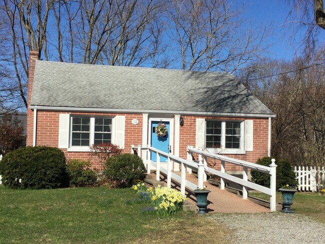

Property Detail
14 Westbrook Rd
Commercialbuilding
Lower Ct River Vly
C
Connecticut
B and X Area of moderate flood hazard, usually the area between the limits of the 100-year and 500-year floods.
0.22 AC
2025
SW Midlsx/Old Saybrk/Rt 9
2025
Hartford
630101
Hartford-West Hartford-East Hartford, CT
1,536 SF
ESSE-000043-000000-000017
NEARBY LISTINGS FOR SALE OR LEASE
DEMOGRAPHICS near 14 Westbrook Rd
1 mile
3 mile
5 mile
2025 Total Population
1,627
11,344
26,518
2030 Population
1,628
11,458
26,911
Pop Growth 2025-2030
+ 0.06%
+ 1.00%
+ 1.48%
Average Age
51
49
48
2025 Total Households
745
5,008
11,463
HH Growth 2025-2030
0.00%
+ 1.00%
+ 1.57%
Median Household Inc
$87,779
$96,804
$99,098
Avg Household Size
2.10
2.20
2.20
2025 Avg HH Vehicles
2.00
2.00
2.00
Median Home Value
$538,210
$486,908
$474,285
Median Year Built
1967
1969
1970
Nearby Places
Map Layers
Map Styles
 Street
 Aerial
Transit
 Traffic
 Biking
Places
Listings with unknown addresses are not visible on the map
- Restaurants
- Banks
- Shops
- Fitness
- Groceries
PUBLIC TRANSPORTATION
COMMUTER RAIL
Old Saybrook (Shore Line East - Shore Line East)
Drive
Walk
Distance
Old Saybrook (Shore Line East - Shore Line East)
10 min
5.0 mi
Drive
Walk
Distance
10 min
5.1 mi
AIRPORT
Tweed/New Haven
Drive
Walk
Distance
Tweed/New Haven
41 min
28.9 mi
Freight Ports
Port of New Haven
Drive
Walk
Distance
Port of New Haven
41 min
29.5 mi
SALE & LEASE HISTORY
LISTING DATE
SALE/LEASE

Apr 13, 2021
For Sale
Nearby Properties
Address
Land Use
TOTAL SIZE
Lot Size
Zoning
Address
Land Use
TOTAL SIZE
Lot Size
Zoning
66.05 AC
PRD
Address
Land Use
TOTAL SIZE
Lot Size
Zoning
108.89 AC
RLC
Address
Land Use
TOTAL SIZE
Lot Size
Zoning
38.67 AC
R60
Address
Land Use
TOTAL SIZE
Lot Size
Zoning
2,100 SF
434.75 AC
R80
Address
Land Use
TOTAL SIZE
Lot Size
Zoning
7.60 AC
VRD
Address
Land Use
TOTAL SIZE
Lot Size
Zoning
189,678 SF
44.72 AC
LI
Address
Land Use
TOTAL SIZE
Lot Size
Zoning
14.98 AC
VR
Address
Land Use
TOTAL SIZE
Lot Size
Zoning
24,360 SF
7.78 AC
B-2
Address
Land Use
TOTAL SIZE
Lot Size
Zoning
18.49 AC
HDD
Address
Land Use
TOTAL SIZE
Lot Size
Zoning
120,144 SF
17.10 AC
RLM
Address
Land Use
TOTAL SIZE
Lot Size
Zoning
5.10 AC
AA-3
Address
Land Use
TOTAL SIZE
Lot Size
Zoning
151,159 SF
6.30 AC
VID
Address
Land Use
TOTAL SIZE
Lot Size
Zoning
18,494 SF
10.40 AC
RU
Address
Land Use
TOTAL SIZE
Lot Size
Zoning
18.80 AC
RU
Address
Land Use
TOTAL SIZE
Lot Size
Zoning
13,739 SF
0.65 AC
VCD
Address
Land Use
TOTAL SIZE
Lot Size
Zoning
62.50 AC
RU
Address
Land Use
TOTAL SIZE
Lot Size
Zoning
849 AC
C
Address
Land Use
TOTAL SIZE
Lot Size
Zoning
3.87 AC
LI
Address
Land Use
TOTAL SIZE
Lot Size
Zoning
146,466 SF
13.55 AC
VID
Address
Land Use
TOTAL SIZE
Lot Size
Zoning
15,236 SF
4 AC
VR
Address
Land Use
TOTAL SIZE
Lot Size
Zoning
27,277 SF
C
Address
Land Use
TOTAL SIZE
Lot Size
Zoning
13.23 AC
WF
Address
Land Use
TOTAL SIZE
Lot Size
Zoning
5.12 AC
WF
Address
Land Use
TOTAL SIZE
Lot Size
Zoning
27,225 SF
2.45 AC
VCD
Address
Land Use
TOTAL SIZE
Lot Size
Zoning
0.78 AC
WF
Address
Land Use
TOTAL SIZE
Lot Size
Zoning
6.51 AC
R80
Address
Land Use
TOTAL SIZE
Lot Size
Zoning
8.10 AC
C
Address
Land Use
TOTAL SIZE
Lot Size
Zoning
14,382 SF
1.87 AC
VMU
Address
Land Use
TOTAL SIZE
Lot Size
Zoning
15,730 SF
2.19 AC
B
Address
Land Use
TOTAL SIZE
Lot Size
Zoning
25,248 SF
1.65 AC
B
The World's #1 Commercial Real Estate Marketplace
Connect with us
© 2026 CoStar Group
The information above has been obtained from sources believed reliable. While we do not doubt its accuracy we have not verified it and make no guarantee, warranty or representation about it. It is your responsibility to independently confirm its accuracy and completeness. Any projections, opinions, assumptions, or estimates used are for example only and do not represent the current or future performance of the property. The value of this transaction to you depends on tax and other factors which should be evaluated by your tax, financial, and legal advisors. You and your advisors should conduct a careful, independent investigation of the property to determine to your satisfaction the suitability of the property for your needs.