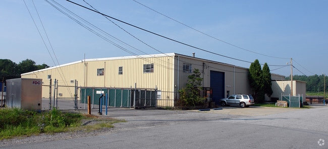
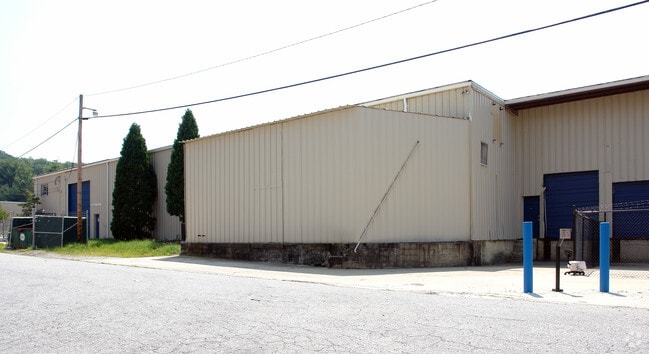
Property Record
14 Weston Road Ext, Arden, NC 28704

NEARBY LISTINGS FOR SALE OR LEASE
Property Detail
14 Weston Road Ext
9654-32-9106-00000
C W Beale Estate
Shipyard
SUBDIV: C W BEALE ESTATE BLOCK: LOT: SECTION: PLAT: 0024-0055
X
Buncombe
3700965400J
North Carolina
0
2.21 AC
2025
S Asheville/Royal Pines
002205
Asheville
49,337 SF
Asheville, NC
DEMOGRAPHICS near 14 Weston Road Ext
1 Mile
3 Mile
5 Mile
2024 Total Population
6,351
32,826
60,779
2029 Population
6,483
34,055
63,148
Pop Growth 2024-2029
+ 2.08%
+ 3.74%
+ 3.90%
Average Age
40
42
43
2024 Total Households
2,592
14,227
26,241
HH Growth 2024-2029
+ 1.54%
+ 3.32%
+ 3.51%
Median Household Inc
$67,393
$69,613
$72,499
Avg Household Size
2.40
2.30
2.30
2024 Avg HH Vehicles
2.00
2.00
2.00
Median Home Value
$301,797
$345,012
$359,348
Median Year Built
1985
1994
1996
Nearby Places
Map Layers
Map Styles
 Street
 Aerial
- Restaurants
- Banks
- Shops
- Fitness
- Groceries
PUBLIC TRANSPORTATION
AIRPORT
Asheville Regional
DRIVE
WALK
Distance
Asheville Regional
6 min
2.9 mi
Nearby Properties
Address
Land Use
TOTAL SIZE
Lot Size
Zoning
Address
Land Use
TOTAL SIZE
Lot Size
Zoning
416,455 SF
135.80 AC
RM16
Address
Land Use
TOTAL SIZE
Lot Size
Zoning
346,375 SF
58.11 AC
INST
Address
Land Use
TOTAL SIZE
Lot Size
Zoning
107,063 SF
567.34 AC
AI
Address
Land Use
TOTAL SIZE
Lot Size
Zoning
110,173 SF
28.13 AC
R-2
Address
Land Use
TOTAL SIZE
Lot Size
Zoning
281,505 SF
38.35 AC
10000070~M
Address
Land Use
TOTAL SIZE
Lot Size
Zoning
78,745 SF
14.73 AC
HB
Address
Land Use
TOTAL SIZE
Lot Size
Zoning
85,103 SF
11.69 AC
RES EXP
Address
Land Use
TOTAL SIZE
Lot Size
Zoning
66,863 SF
7.48 AC
INST
Address
Land Use
TOTAL SIZE
Lot Size
Zoning
57,836 SF
1.09 AC
UV
Address
Land Use
TOTAL SIZE
Lot Size
Zoning
207,701 SF
458.72 AC
R-3
Address
Land Use
TOTAL SIZE
Lot Size
Zoning
107,408 SF
21.92 AC
R-3
Address
Land Use
TOTAL SIZE
Lot Size
Zoning
183,020 SF
22.84 AC
RM16
Address
Land Use
TOTAL SIZE
Lot Size
Zoning
198,705 SF
32.46 AC
HB
Address
Land Use
TOTAL SIZE
Lot Size
Zoning
227,740 SF
36.18 AC
INST
Address
Land Use
TOTAL SIZE
Lot Size
Zoning
82,267 SF
14.05 AC
CI
Address
Land Use
TOTAL SIZE
Lot Size
Zoning
73,420 SF
10.24 AC
RM16
Address
Land Use
TOTAL SIZE
Lot Size
Zoning
155,715 SF
36.84 AC
RM16
Address
Land Use
TOTAL SIZE
Lot Size
Zoning
80,872 SF
18.84 AC
RM16
Address
Land Use
TOTAL SIZE
Lot Size
Zoning
93,197 SF
6.32 AC
RES EXP
Address
Land Use
TOTAL SIZE
Lot Size
Zoning
71,574 SF
15.85 AC
RM16
Address
Land Use
TOTAL SIZE
Lot Size
Zoning
63,030 SF
5.70 AC
RES EXP
Address
Land Use
TOTAL SIZE
Lot Size
Zoning
3,466 SF
11.32 AC
10000832~M
Address
Land Use
TOTAL SIZE
Lot Size
Zoning
4,839 SF
9.46 AC
10002512~C
Address
Land Use
TOTAL SIZE
Lot Size
Zoning
48,343 SF
11.67 AC
RM16
Address
Land Use
TOTAL SIZE
Lot Size
Zoning
92,772 SF
12.30 AC
R-2
Address
Land Use
TOTAL SIZE
Lot Size
Zoning
899,676 SF
46.99 AC
1006235~M-
Address
Land Use
TOTAL SIZE
Lot Size
Zoning
35,047 SF
4.32 AC
RES EXP
Address
Land Use
TOTAL SIZE
Lot Size
Zoning
39,769 SF
6.17 AC
HB
Address
Land Use
TOTAL SIZE
Lot Size
Zoning
43,882 SF
9.71 AC
1016337~C1
Address
Land Use
TOTAL SIZE
Lot Size
Zoning
24.83 AC
1012291~M-
The World's #1 Commercial Real Estate Marketplace
Connect with us
© 2025 CoStar Group
The information above has been obtained from sources believed reliable. While we do not doubt its accuracy we have not verified it and make no guarantee, warranty or representation about it. It is your responsibility to independently confirm its accuracy and completeness. Any projections, opinions, assumptions, or estimates used are for example only and do not represent the current or future performance of the property. The value of this transaction to you depends on tax and other factors which should be evaluated by your tax, financial, and legal advisors. You and your advisors should conduct a careful, independent investigation of the property to determine to your satisfaction the suitability of the property for your needs.