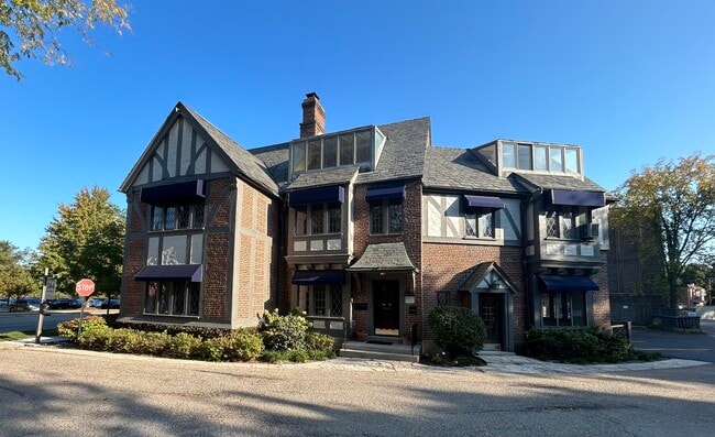
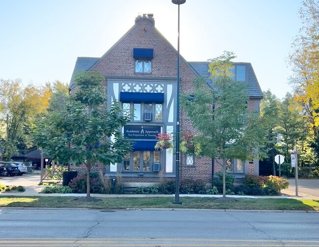
Property Record
192 Church Rd, Winnetka, IL 60093


Current Lease Availabilities
NEARBY LISTINGS FOR SALE OR LEASE
Property Detail
192 Church Rd
Chicago-Naperville-Elgin, IL-IN
Odmans
05-21-311-017-0000
Cook
Sfr
Illinois
X
0.22 AC
17031C0251K
Central North
3,428 SF
Chicago
DEMOGRAPHICS near 192 Church Rd
1 Mile
3 Mile
5 Mile
2024 Total Population
10,966
76,042
221,438
2029 Population
10,666
74,165
216,035
Pop Growth 2024-2029
(2.74%)
(2.47%)
(2.44%)
Average Age
40
42
42
2024 Total Households
3,533
26,703
81,042
HH Growth 2024-2029
(3.00%)
(2.73%)
(2.63%)
Median Household Inc
$232,082
$166,948
$110,324
Avg Household Size
3.00
2.70
2.60
2024 Avg HH Vehicles
2.00
2.00
2.00
Median Home Value
$1,017,122
$764,301
$531,318
Median Year Built
1947
1953
1957
Nearby Places
Map Layers
Map Styles
 Street
 Aerial
- Restaurants
- Banks
- Shops
- Fitness
- Groceries
PUBLIC TRANSPORTATION
COMMUTER RAIL
Indian Hill Station (Union Pacific North Line - Northeast Illinois Regional Commuter Railroad (Metra))
DRIVE
WALK
Distance
Indian Hill Station (Union Pacific North Line - Northeast Illinois Regional Commuter Railroad (Metra))
1 min
7 min
0.4 mi
Winnetka Station (Union Pacific North Line - Northeast Illinois Regional Commuter Railroad (Metra))
DRIVE
WALK
Distance
Winnetka Station (Union Pacific North Line - Northeast Illinois Regional Commuter Railroad (Metra))
2 min
13 min
0.7 mi
AIRPORT
Chicago O'Hare International
DRIVE
WALK
Distance
Chicago O'Hare International
30 min
18.5 mi
Chicago Midway International
DRIVE
WALK
Distance
Chicago Midway International
42 min
25.7 mi
Freight Ports
Port Milwaukee
DRIVE
WALK
Distance
Port Milwaukee
84 min
69.0 mi
Nearby Properties
Address
Land Use
TOTAL SIZE
Lot Size
Zoning
Address
Land Use
TOTAL SIZE
Lot Size
Zoning
165,067 SF
10.88 AC
Address
Land Use
TOTAL SIZE
Lot Size
Zoning
415,554 SF
7.51 AC
Address
Land Use
TOTAL SIZE
Lot Size
Zoning
172,538 SF
5.60 AC
Address
Land Use
TOTAL SIZE
Lot Size
Zoning
10.58 AC
Address
Land Use
TOTAL SIZE
Lot Size
Zoning
6.90 AC
Address
Land Use
TOTAL SIZE
Lot Size
Zoning
0.84 AC
Address
Land Use
TOTAL SIZE
Lot Size
Zoning
163,981 SF
4 AC
Address
Land Use
TOTAL SIZE
Lot Size
Zoning
121,642 SF
1.65 AC
Address
Land Use
TOTAL SIZE
Lot Size
Zoning
172,544 SF
7.22 AC
Address
Land Use
TOTAL SIZE
Lot Size
Zoning
206,139 SF
2.19 AC
Address
Land Use
TOTAL SIZE
Lot Size
Zoning
199,280 SF
3.10 AC
Address
Land Use
TOTAL SIZE
Lot Size
Zoning
97.02 AC
Address
Land Use
TOTAL SIZE
Lot Size
Zoning
1.62 AC
Address
Land Use
TOTAL SIZE
Lot Size
Zoning
94,063 SF
1.61 AC
Address
Land Use
TOTAL SIZE
Lot Size
Zoning
47,283 SF
1.18 AC
Address
Land Use
TOTAL SIZE
Lot Size
Zoning
108,890 SF
8.87 AC
Address
Land Use
TOTAL SIZE
Lot Size
Zoning
60,301 SF
3.35 AC
Address
Land Use
TOTAL SIZE
Lot Size
Zoning
219,116 SF
4.97 AC
Address
Land Use
TOTAL SIZE
Lot Size
Zoning
223,203 SF
3.75 AC
Address
Land Use
TOTAL SIZE
Lot Size
Zoning
130,034 SF
0.92 AC
Address
Land Use
TOTAL SIZE
Lot Size
Zoning
96.33 AC
Address
Land Use
TOTAL SIZE
Lot Size
Zoning
128,372 SF
5.21 AC
Address
Land Use
TOTAL SIZE
Lot Size
Zoning
130,147 SF
5.67 AC
Address
Land Use
TOTAL SIZE
Lot Size
Zoning
1.69 AC
Address
Land Use
TOTAL SIZE
Lot Size
Zoning
138,323 SF
0.34 AC
Address
Land Use
TOTAL SIZE
Lot Size
Zoning
Address
Land Use
TOTAL SIZE
Lot Size
Zoning
128,366 SF
1 AC
Address
Land Use
TOTAL SIZE
Lot Size
Zoning
63,298 SF
3.30 AC
Address
Land Use
TOTAL SIZE
Lot Size
Zoning
39,984 SF
2.31 AC
Address
Land Use
TOTAL SIZE
Lot Size
Zoning
32,671 SF
0.53 AC
The World's #1 Commercial Real Estate Marketplace
Connect with us
© 2026 CoStar Group
The information above has been obtained from sources believed reliable. While we do not doubt its accuracy we have not verified it and make no guarantee, warranty or representation about it. It is your responsibility to independently confirm its accuracy and completeness. Any projections, opinions, assumptions, or estimates used are for example only and do not represent the current or future performance of the property. The value of this transaction to you depends on tax and other factors which should be evaluated by your tax, financial, and legal advisors. You and your advisors should conduct a careful, independent investigation of the property to determine to your satisfaction the suitability of the property for your needs.