Property Record
140 Airstrip Rd, East Stroudsburg, PA 18301

NEARBY LISTINGS FOR SALE OR LEASE
Property Detail
140 Airstrip Rd
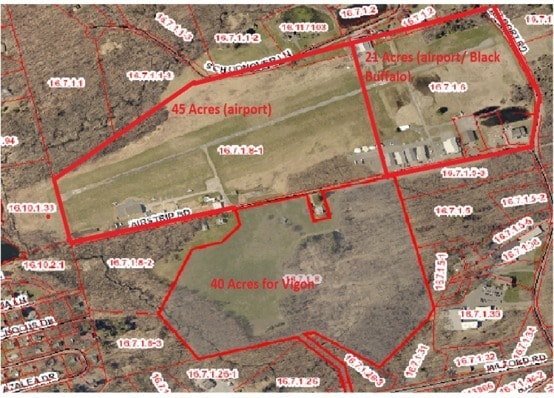
16.7.1.8-1
Pocono Stroudsburg Airport
Airport
Monroe
AE
Pennsylvania
42089C0291E
43.79 AC
2025
Monroe County
2025
Philadelphia
300502
East Stroudsburg, PA
560 SF
DEMOGRAPHICS near 140 Airstrip Rd
1 Mile
3 Mile
5 Mile
2024 Total Population
2,347
20,557
48,984
2029 Population
2,301
20,205
48,432
Pop Growth 2024-2029
(1.96%)
(1.71%)
(1.13%)
Average Age
41
40
41
2024 Total Households
825
7,161
17,828
HH Growth 2024-2029
(1.94%)
(1.35%)
(1.04%)
Median Household Inc
$127,045
$85,536
$80,290
Avg Household Size
2.80
2.60
2.60
2024 Avg HH Vehicles
2.00
2.00
2.00
Median Home Value
$254,560
$243,453
$233,114
Median Year Built
1992
1980
1982
Nearby Places
Map Layers
Map Styles
 Street
 Aerial
- Restaurants
- Banks
- Shops
- Fitness
- Groceries
SALE & LEASE HISTORY
LISTING DATE
SALE/LEASE

May 26, 2023
For Lease
Nearby Properties
Address
Land Use
TOTAL SIZE
Lot Size
Zoning
Address
Land Use
TOTAL SIZE
Lot Size
Zoning
412,170 SF
Address
Land Use
TOTAL SIZE
Lot Size
Zoning
260,728 SF
23.15 AC
IU
Address
Land Use
TOTAL SIZE
Lot Size
Zoning
225,935 SF
3.74 AC
IM
Address
Land Use
TOTAL SIZE
Lot Size
Zoning
102,240 SF
34.13 AC
R-2
Address
Land Use
TOTAL SIZE
Lot Size
Zoning
254,320 SF
0.23 AC
IU
Address
Land Use
TOTAL SIZE
Lot Size
Zoning
16,664 SF
43.49 AC
R2
Address
Land Use
TOTAL SIZE
Lot Size
Zoning
198,124 SF
41.05 AC
R2
Address
Land Use
TOTAL SIZE
Lot Size
Zoning
91,431 SF
Address
Land Use
TOTAL SIZE
Lot Size
Zoning
112,582 SF
26.38 AC
B2
Address
Land Use
TOTAL SIZE
Lot Size
Zoning
129,257 SF
1.92 AC
IU
Address
Land Use
TOTAL SIZE
Lot Size
Zoning
126,740 SF
1.67 AC
IU
Address
Land Use
TOTAL SIZE
Lot Size
Zoning
90,072 SF
3.15 AC
IU
Address
Land Use
TOTAL SIZE
Lot Size
Zoning
216 SF
109.59 AC
S-1
Address
Land Use
TOTAL SIZE
Lot Size
Zoning
20,984 SF
14.30 AC
I-E
Address
Land Use
TOTAL SIZE
Lot Size
Zoning
83,103 SF
30.80 AC
IU
Address
Land Use
TOTAL SIZE
Lot Size
Zoning
47,628 SF
4.40 AC
C1
Address
Land Use
TOTAL SIZE
Lot Size
Zoning
34,352 SF
9.83 AC
C1
Address
Land Use
TOTAL SIZE
Lot Size
Zoning
3,756 SF
314.03 AC
RC
Address
Land Use
TOTAL SIZE
Lot Size
Zoning
40,978 SF
0.45 AC
C1
Address
Land Use
TOTAL SIZE
Lot Size
Zoning
30,622 SF
3.55 AC
C1
Address
Land Use
TOTAL SIZE
Lot Size
Zoning
72,774 SF
4.26 AC
R-1
Address
Land Use
TOTAL SIZE
Lot Size
Zoning
124,674 SF
10.04 AC
M-1
Address
Land Use
TOTAL SIZE
Lot Size
Zoning
60,828 SF
1.18 AC
IU
Address
Land Use
TOTAL SIZE
Lot Size
Zoning
97,438 SF
2.27 AC
IM
Address
Land Use
TOTAL SIZE
Lot Size
Zoning
68,640 SF
0.17 AC
IU
Address
Land Use
TOTAL SIZE
Lot Size
Zoning
31,978 SF
18.89 AC
IU
Address
Land Use
TOTAL SIZE
Lot Size
Zoning
94,066 SF
36.26 AC
R-1
Address
Land Use
TOTAL SIZE
Lot Size
Zoning
67,584 SF
1.98 AC
IU
Address
Land Use
TOTAL SIZE
Lot Size
Zoning
6,417 SF
22.47 AC
C-2
Address
Land Use
TOTAL SIZE
Lot Size
Zoning
21,612 SF
3.70 AC
C1
The World's #1 Commercial Real Estate Marketplace
Connect with us
© 2025 CoStar Group
The information above has been obtained from sources believed reliable. While we do not doubt its accuracy we have not verified it and make no guarantee, warranty or representation about it. It is your responsibility to independently confirm its accuracy and completeness. Any projections, opinions, assumptions, or estimates used are for example only and do not represent the current or future performance of the property. The value of this transaction to you depends on tax and other factors which should be evaluated by your tax, financial, and legal advisors. You and your advisors should conduct a careful, independent investigation of the property to determine to your satisfaction the suitability of the property for your needs.