Property Record
140 Laconia Rd, Belmont, NH 03220
NEARBY LISTINGS FOR SALE OR LEASE
-
-
View all Belmont listings for lease on LoopNet.com
Property Detail
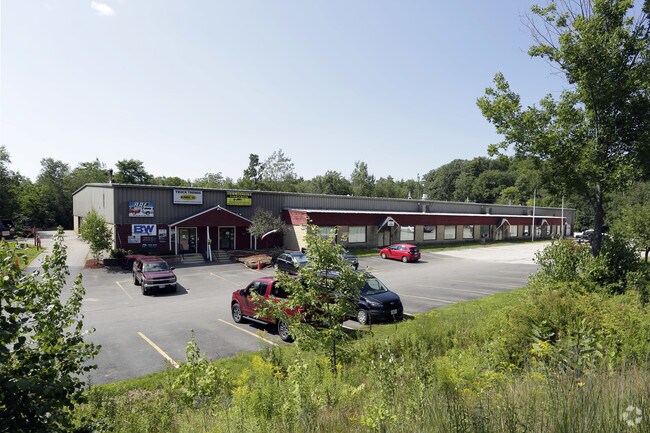
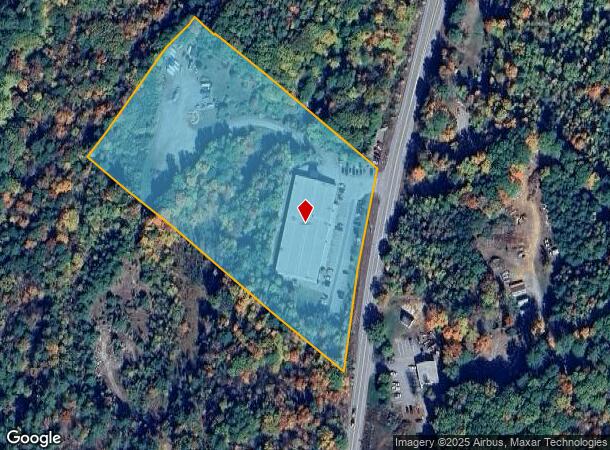
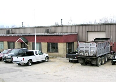
140 Laconia Rd
BLMT-000210-000005
Belknap
Commercialbuilding
New Hampshire
2024
9.43 AC
2024
Concord/New Hampshire North Area
965801
Other Market Areas
35,655 SF
Laconia, NH
DEMOGRAPHICS near 140 Laconia Rd
1 Mile
3 Mile
5 Mile
2024 Total Population
1,346
13,946
26,313
2029 Population
1,374
14,323
27,072
Pop Growth 2024-2029
+ 2.08%
+ 2.70%
+ 2.88%
Average Age
43
42
44
2024 Total Households
559
5,910
11,103
HH Growth 2024-2029
+ 1.79%
+ 2.37%
+ 2.55%
Median Household Inc
$52,727
$56,079
$62,781
Avg Household Size
2.30
2.30
2.30
2024 Avg HH Vehicles
2.00
2.00
2.00
Median Home Value
$213,750
$233,734
$260,818
Median Year Built
1986
1967
1973
Nearby Places
Map Layers
Map Styles
 Street
 Aerial
- Restaurants
- Banks
- Shops
- Fitness
- Groceries
SALE & LEASE HISTORY
LISTING DATE
SALE/LEASE

Nov 13, 2017
For Lease
Nearby Properties
Address
Land Use
TOTAL SIZE
Lot Size
Zoning
Address
Land Use
TOTAL SIZE
Lot Size
Zoning
Address
Land Use
TOTAL SIZE
Lot Size
Zoning
147,353 SF
18.97 AC
UC
Address
Land Use
TOTAL SIZE
Lot Size
Zoning
1,600 SF
24 AC
RS
Address
Land Use
TOTAL SIZE
Lot Size
Zoning
78,038 SF
35 AC
RA
Address
Land Use
TOTAL SIZE
Lot Size
Zoning
1,954 SF
Address
Land Use
TOTAL SIZE
Lot Size
Zoning
77,703 SF
1.50 AC
UC
Address
Land Use
TOTAL SIZE
Lot Size
Zoning
210,552 SF
28.55 AC
COM
Address
Land Use
TOTAL SIZE
Lot Size
Zoning
49,398 SF
29.36 AC
RS
Address
Land Use
TOTAL SIZE
Lot Size
Zoning
4,943 SF
6.71 AC
UC
Address
Land Use
TOTAL SIZE
Lot Size
Zoning
7,150 SF
4.40 AC
UC
Address
Land Use
TOTAL SIZE
Lot Size
Zoning
37,344 SF
15.35 AC
RS
Address
Land Use
TOTAL SIZE
Lot Size
Zoning
46,863 SF
8.71 AC
UC
Address
Land Use
TOTAL SIZE
Lot Size
Zoning
24,048 SF
1.60 AC
UC
Address
Land Use
TOTAL SIZE
Lot Size
Zoning
16,660 SF
1 AC
UC
Address
Land Use
TOTAL SIZE
Lot Size
Zoning
4,102 SF
34.50 AC
RES
Address
Land Use
TOTAL SIZE
Lot Size
Zoning
53,351 SF
1.90 AC
UC
Address
Land Use
TOTAL SIZE
Lot Size
Zoning
46,544 SF
3.77 AC
UC
Address
Land Use
TOTAL SIZE
Lot Size
Zoning
4.71 AC
RS
Address
Land Use
TOTAL SIZE
Lot Size
Zoning
41,350 SF
2.51 AC
UC
Address
Land Use
TOTAL SIZE
Lot Size
Zoning
2.09 AC
PC
Address
Land Use
TOTAL SIZE
Lot Size
Zoning
10,561 SF
2.20 AC
UC
Address
Land Use
TOTAL SIZE
Lot Size
Zoning
21,204 SF
0.97 AC
UC
Address
Land Use
TOTAL SIZE
Lot Size
Zoning
87,549 SF
DRD
Address
Land Use
TOTAL SIZE
Lot Size
Zoning
2,400 SF
17.41 AC
COM
Address
Land Use
TOTAL SIZE
Lot Size
Zoning
37,058 SF
DRD
Address
Land Use
TOTAL SIZE
Lot Size
Zoning
48,652 SF
13.68 AC
I
Address
Land Use
TOTAL SIZE
Lot Size
Zoning
8,288 SF
8.40 AC
RA
Address
Land Use
TOTAL SIZE
Lot Size
Zoning
709 SF
175.99 AC
COM
Address
Land Use
TOTAL SIZE
Lot Size
Zoning
19,477 SF
1.95 AC
UC
Address
Land Use
TOTAL SIZE
Lot Size
Zoning
2,631 SF
2.38 AC
UC
The World's #1 Commercial Real Estate Marketplace
Connect with us
© 2026 CoStar Group
The information above has been obtained from sources believed reliable. While we do not doubt its accuracy we have not verified it and make no guarantee, warranty or representation about it. It is your responsibility to independently confirm its accuracy and completeness. Any projections, opinions, assumptions, or estimates used are for example only and do not represent the current or future performance of the property. The value of this transaction to you depends on tax and other factors which should be evaluated by your tax, financial, and legal advisors. You and your advisors should conduct a careful, independent investigation of the property to determine to your satisfaction the suitability of the property for your needs.