Property Record
140 N Walnut St, Augusta, KS 67010

Save to a Folder
{{folder.Name}}
{{folder.ListingIds.length}} Properties
{{folder.ListingIds.length}} Property
Create a New Folder
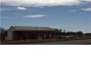
Property Detail
140 N Walnut St
Wichita, KS
S27, T27, R04E, BEG 442.98S NW/C SE1/4 SW96.39 TO ELY ROW HWY 77 NELY288.7 NW10 NE105.12 SE126.98 SW256.44 TO POB
298-27-0-00-00-004-04-0
Butler
Warehouse
Kansas
2019
0.70 AC
2026
Augusta/El Dorado
020800
Wichita
2,362 SF
NEARBY LISTINGS FOR SALE OR LEASE
-
-
View all Augusta listings for sale on LoopNet.com
DEMOGRAPHICS near 140 N Walnut St
1 mile
3 mile
5 mile
2025 Total Population
2,119
9,262
12,342
2030 Population
2,187
9,401
12,513
Pop Growth 2025-2030
+ 3.21%
+ 1.50%
+ 1.39%
Average Age
37
40
41
2025 Total Households
871
3,725
4,845
HH Growth 2025-2030
+ 3.33%
+ 1.58%
+ 1.49%
Median Household Inc
$47,828
$55,599
$63,877
Avg Household Size
2.40
2.40
2.50
2025 Avg HH Vehicles
2.00
2.00
2.00
Median Home Value
$112,571
$156,786
$188,211
Median Year Built
1959
1972
1977
Nearby Places
Map Layers
Map Styles
 Street
 Aerial
Layers
 Traffic
 Biking
Places
Listings with unknown addresses are not visible on the map
- Restaurants
- Banks
- Shops
- Fitness
- Groceries
PUBLIC TRANSPORTATION
AIRPORT
Wichita Dwight D Eisenhower Ntl
Drive
Walk
Distance
Wichita Dwight D Eisenhower Ntl
36 min
26.6 mi
Freight Ports
Tulsa Port Of Catoosa
Drive
Walk
Distance
Tulsa Port Of Catoosa
214 min
180.0 mi
Nearby Properties
Address
Land Use
TOTAL SIZE
Lot Size
Zoning
Address
Land Use
TOTAL SIZE
Lot Size
Zoning
5.10 AC
Address
Land Use
TOTAL SIZE
Lot Size
Zoning
42.50 AC
Address
Land Use
TOTAL SIZE
Lot Size
Zoning
Address
Land Use
TOTAL SIZE
Lot Size
Zoning
28,587 SF
5 AC
Address
Land Use
TOTAL SIZE
Lot Size
Zoning
20.90 AC
Address
Land Use
TOTAL SIZE
Lot Size
Zoning
4.80 AC
Address
Land Use
TOTAL SIZE
Lot Size
Zoning
45,938 SF
5 AC
Address
Land Use
TOTAL SIZE
Lot Size
Zoning
8.40 AC
Address
Land Use
TOTAL SIZE
Lot Size
Zoning
6.50 AC
Address
Land Use
TOTAL SIZE
Lot Size
Zoning
3.30 AC
Address
Land Use
TOTAL SIZE
Lot Size
Zoning
15,136 SF
10.10 AC
Address
Land Use
TOTAL SIZE
Lot Size
Zoning
3.20 AC
Address
Land Use
TOTAL SIZE
Lot Size
Zoning
120,432 SF
15 AC
Address
Land Use
TOTAL SIZE
Lot Size
Zoning
3,000 SF
6.30 AC
Address
Land Use
TOTAL SIZE
Lot Size
Zoning
0.13 AC
Address
Land Use
TOTAL SIZE
Lot Size
Zoning
2,804 SF
3.70 AC
Address
Land Use
TOTAL SIZE
Lot Size
Zoning
0.30 AC
Address
Land Use
TOTAL SIZE
Lot Size
Zoning
213.40 AC
Address
Land Use
TOTAL SIZE
Lot Size
Zoning
32,047 SF
1.10 AC
Address
Land Use
TOTAL SIZE
Lot Size
Zoning
12.30 AC
Address
Land Use
TOTAL SIZE
Lot Size
Zoning
0.90 AC
Address
Land Use
TOTAL SIZE
Lot Size
Zoning
4,743 SF
0.99 AC
Address
Land Use
TOTAL SIZE
Lot Size
Zoning
1,440 SF
34 AC
Address
Land Use
TOTAL SIZE
Lot Size
Zoning
40,670 SF
5.20 AC
Address
Land Use
TOTAL SIZE
Lot Size
Zoning
6.10 AC
Address
Land Use
TOTAL SIZE
Lot Size
Zoning
6.40 AC
Address
Land Use
TOTAL SIZE
Lot Size
Zoning
1,457 SF
6 AC
Address
Land Use
TOTAL SIZE
Lot Size
Zoning
12,342 SF
5.30 AC
Address
Land Use
TOTAL SIZE
Lot Size
Zoning
16,359 SF
0.76 AC
Address
Land Use
TOTAL SIZE
Lot Size
Zoning
7,006 SF
6.40 AC
The World's #1 Commercial Real Estate Marketplace
Connect with us
© 2026 CoStar Group
The information above has been obtained from sources believed reliable. While we do not doubt its accuracy we have not verified it and make no guarantee, warranty or representation about it. It is your responsibility to independently confirm its accuracy and completeness. Any projections, opinions, assumptions, or estimates used are for example only and do not represent the current or future performance of the property. The value of this transaction to you depends on tax and other factors which should be evaluated by your tax, financial, and legal advisors. You and your advisors should conduct a careful, independent investigation of the property to determine to your satisfaction the suitability of the property for your needs.