Property Record
140 W 62Nd St, Chicago, IL 60621
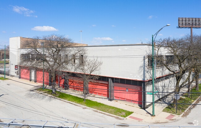

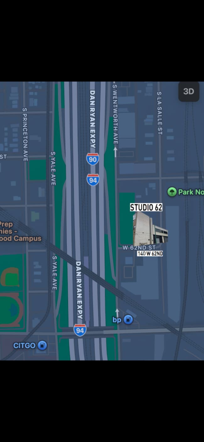
Property Detail
140 W 62Nd St
20-16-419-021-0000
B F (JACOBS) SUB OF PART OF ORIGINAL LTS 12-14 IN SCH OOL TRUSTEES SUB OF SEC 16-38-14
Industrialgeneral
Cook
C1-2
Illinois
B and X Area of moderate flood hazard, usually the area between the limits of the 100-year and 500-year floods.
12-14
2023
0.38 AC
2025
South Chicago
834600
Chicago
28,400 SF
Chicago-Naperville-Elgin, IL-IN
NEARBY LISTINGS FOR SALE OR LEASE
DEMOGRAPHICS near 140 W 62Nd St
1 mile
3 mile
5 mile
2025 Total Population
30,164
309,647
693,705
2030 Population
30,689
309,154
684,986
Pop Growth 2025-2030
+ 1.74%
(0.16%)
(1.26%)
Average Age
36
38
39
2025 Total Households
12,173
128,624
268,986
HH Growth 2025-2030
+ 1.58%
(0.21%)
(1.14%)
Median Household Inc
$27,467
$42,657
$50,808
Avg Household Size
2.40
2.30
2.50
2025 Avg HH Vehicles
1.00
1.00
1.00
Median Home Value
$212,500
$234,637
$239,091
Median Year Built
1958
1949
1949
Nearby Places
Map Layers
Map Styles
 Street
 Aerial
Layers
 Traffic
 Biking
Places
Listings with unknown addresses are not visible on the map
- Restaurants
- Banks
- Shops
- Fitness
- Groceries
PUBLIC TRANSPORTATION
TRANSIT/SUBWAY
63Rd Street Station (Red Line - Chicago Transit Authority "L" Trains (The "L"))
Drive
Walk
Distance
63Rd Street Station (Red Line - Chicago Transit Authority "L" Trains (The "L"))
8 min
4 min
0.2 mi
King Drive Station (Green Line - Chicago Transit Authority "L" Trains (The "L"))
Drive
Walk
Distance
King Drive Station (Green Line - Chicago Transit Authority "L" Trains (The "L"))
3 min
19 min
1.0 mi
Halsted Station (Green Line) (Green Line - Chicago Transit Authority "L" Trains (The "L"))
Drive
Walk
Distance
Halsted Station (Green Line) (Green Line - Chicago Transit Authority "L" Trains (The "L"))
5 min
19 min
1.0 mi
Garfield Station (Red Line) (Red Line - Chicago Transit Authority "L" Trains (The "L"))
Drive
Walk
Distance
Garfield Station (Red Line) (Red Line - Chicago Transit Authority "L" Trains (The "L"))
8 min
20 min
1.0 mi
COMMUTER RAIL
63Rd Street Station (Metra Electric Line - Northeast Illinois Regional Commuter Railroad (Metra), South Shore Line - Northeast Illinois Regional Commuter Railroad (Metra))
Drive
Walk
Distance
63Rd Street Station (Metra Electric Line - Northeast Illinois Regional Commuter Railroad (Metra), South Shore Line - Northeast Illinois Regional Commuter Railroad (Metra))
6 min
2.5 mi
59Th Street (University Of Chicago) Station (Metra Electric Line - Northeast Illinois Regional Commuter Railroad (Metra))
Drive
Walk
Distance
59Th Street (University Of Chicago) Station (Metra Electric Line - Northeast Illinois Regional Commuter Railroad (Metra))
7 min
2.8 mi
AIRPORT
Chicago Midway International
Drive
Walk
Distance
Chicago Midway International
15 min
7.3 mi
Chicago O'Hare International
Drive
Walk
Distance
Chicago O'Hare International
38 min
24.4 mi
Freight Ports
Port Milwaukee
Drive
Walk
Distance
Port Milwaukee
116 min
92.6 mi
SALE & LEASE HISTORY
LISTING DATE
SALE/LEASE

Feb 01, 2018
For Lease
Aug 15, 2017
For Sale
Aug 03, 2025
For Lease
Nearby Properties
Address
Land Use
TOTAL SIZE
Lot Size
Zoning
Address
Land Use
TOTAL SIZE
Lot Size
Zoning
10.73 AC
PD 1243
Address
Land Use
TOTAL SIZE
Lot Size
Zoning
Address
Land Use
TOTAL SIZE
Lot Size
Zoning
0.28 AC
PD 38
Address
Land Use
TOTAL SIZE
Lot Size
Zoning
134,800 SF
2.53 AC
PD 1273
Address
Land Use
TOTAL SIZE
Lot Size
Zoning
3.14 AC
PD 1211
Address
Land Use
TOTAL SIZE
Lot Size
Zoning
1,302,463 SF
3.14 AC
PD 1211
Address
Land Use
TOTAL SIZE
Lot Size
Zoning
115,000 SF
1.97 AC
C1-2
Address
Land Use
TOTAL SIZE
Lot Size
Zoning
0.91 AC
PD 1177
Address
Land Use
TOTAL SIZE
Lot Size
Zoning
2.65 AC
PD 38
Address
Land Use
TOTAL SIZE
Lot Size
Zoning
304,685 SF
1.11 AC
PD 1218
Address
Land Use
TOTAL SIZE
Lot Size
Zoning
115,000 SF
1.12 AC
C1-2
Address
Land Use
TOTAL SIZE
Lot Size
Zoning
283,180 SF
1.41 AC
M2-3
Address
Land Use
TOTAL SIZE
Lot Size
Zoning
7,200 SF
0.22 AC
B3-3
Address
Land Use
TOTAL SIZE
Lot Size
Zoning
156,800 SF
2.65 AC
PD 38
Address
Land Use
TOTAL SIZE
Lot Size
Zoning
PD 43
Address
Land Use
TOTAL SIZE
Lot Size
Zoning
Address
Land Use
TOTAL SIZE
Lot Size
Zoning
451,349 SF
1.62 AC
PD 1062
Address
Land Use
TOTAL SIZE
Lot Size
Zoning
0.29 AC
PD 1548
Address
Land Use
TOTAL SIZE
Lot Size
Zoning
4,900 SF
0.29 AC
PD 1548
Address
Land Use
TOTAL SIZE
Lot Size
Zoning
1.65 AC
B2-3
Address
Land Use
TOTAL SIZE
Lot Size
Zoning
PD 43
Address
Land Use
TOTAL SIZE
Lot Size
Zoning
769,600 SF
PD 282
Address
Land Use
TOTAL SIZE
Lot Size
Zoning
78,000 SF
0.62 AC
RM-5
Address
Land Use
TOTAL SIZE
Lot Size
Zoning
117,557 SF
2.69 AC
B3-3
Address
Land Use
TOTAL SIZE
Lot Size
Zoning
36,365 SF
Address
Land Use
TOTAL SIZE
Lot Size
Zoning
7.47 AC
RT-4
Address
Land Use
TOTAL SIZE
Lot Size
Zoning
33,162 SF
1.18 AC
RM-5
Address
Land Use
TOTAL SIZE
Lot Size
Zoning
134,655 SF
2.40 AC
B3-3
Address
Land Use
TOTAL SIZE
Lot Size
Zoning
283,228 SF
14.47 AC
PMD 8
Address
Land Use
TOTAL SIZE
Lot Size
Zoning
1.60 AC
RT-4
The World's #1 Commercial Real Estate Marketplace
Connect with us
© 2026 CoStar Group
The information above has been obtained from sources believed reliable. While we do not doubt its accuracy we have not verified it and make no guarantee, warranty or representation about it. It is your responsibility to independently confirm its accuracy and completeness. Any projections, opinions, assumptions, or estimates used are for example only and do not represent the current or future performance of the property. The value of this transaction to you depends on tax and other factors which should be evaluated by your tax, financial, and legal advisors. You and your advisors should conduct a careful, independent investigation of the property to determine to your satisfaction the suitability of the property for your needs.