Property Record
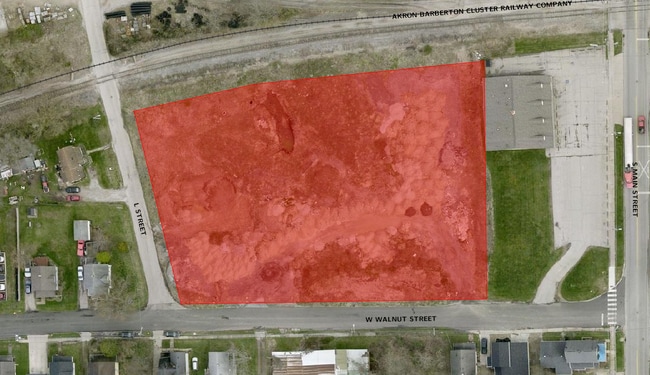
140 W Walnut St, Wadsworth, OH 44281

Property Detail
140 W Walnut St
Cleveland-Elyria, OH
LOTS 195, 196, 197, 198, 863, 862, 194, 193 .000A
040-20C-10-041
MEDINA
Industrialacreage
Ohio
B and X Area of moderate flood hazard, usually the area between the limits of the 100-year and 500-year floods.
195
2025
0.85 AC
2025
Medina County
417001
Cleveland
NEARBY LISTINGS FOR SALE OR LEASE
DEMOGRAPHICS near 140 W Walnut St
1 mile
3 mile
5 mile
2025 Total Population
8,394
27,623
54,285
2030 Population
8,448
27,829
54,712
Pop Growth 2025-2030
+ 0.64%
+ 0.75%
+ 0.79%
Average Age
39
42
42
2025 Total Households
3,392
11,215
22,005
HH Growth 2025-2030
+ 0.62%
+ 0.78%
+ 0.75%
Median Household Inc
$61,512
$75,805
$75,111
Avg Household Size
2.40
2.40
2.40
2025 Avg HH Vehicles
2.00
2.00
2.00
Median Home Value
$211,366
$254,609
$235,798
Median Year Built
1963
1975
1972
Nearby Places
Map Layers
Map Styles
 Street
 Aerial
Layers
 Traffic
 Biking
Places
Listings with unknown addresses are not visible on the map
- Restaurants
- Banks
- Shops
- Fitness
- Groceries
PUBLIC TRANSPORTATION
AIRPORT
Akron-Canton Regional
Drive
Walk
Distance
Akron-Canton Regional
32 min
23.1 mi
Cleveland-Hopkins International
Drive
Walk
Distance
Cleveland-Hopkins International
51 min
34.1 mi
Freight Ports
Port of Toledo
Drive
Walk
Distance
Port of Toledo
164 min
130.1 mi
SALE & LEASE HISTORY
LISTING DATE
SALE/LEASE

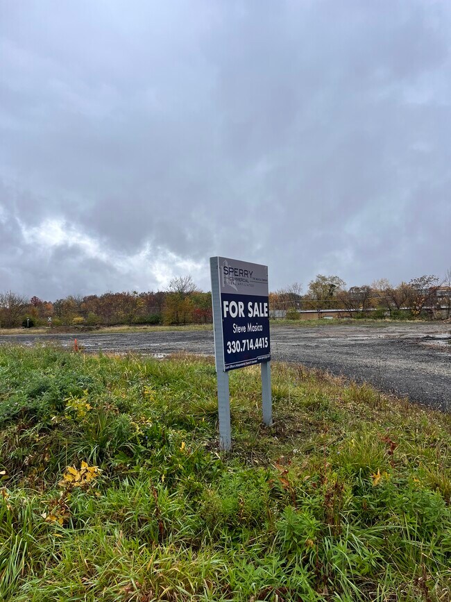
Sep 27, 2023
For Sale
Sep 26, 2023
For Sale
Nearby Properties
Address
Land Use
TOTAL SIZE
Lot Size
Zoning
Address
Land Use
TOTAL SIZE
Lot Size
Zoning
73,550 SF
100.93 AC
Address
Land Use
TOTAL SIZE
Lot Size
Zoning
3,832 SF
56.46 AC
Address
Land Use
TOTAL SIZE
Lot Size
Zoning
2,626 SF
12.89 AC
Address
Land Use
TOTAL SIZE
Lot Size
Zoning
4,697 SF
32.26 AC
Address
Land Use
TOTAL SIZE
Lot Size
Zoning
16,281 SF
14.02 AC
Address
Land Use
TOTAL SIZE
Lot Size
Zoning
51,416 SF
15.13 AC
Address
Land Use
TOTAL SIZE
Lot Size
Zoning
6,573 SF
22.01 AC
Address
Land Use
TOTAL SIZE
Lot Size
Zoning
23,904 SF
4.36 AC
Address
Land Use
TOTAL SIZE
Lot Size
Zoning
54,910 SF
7.46 AC
Address
Land Use
TOTAL SIZE
Lot Size
Zoning
207,631 SF
17.18 AC
Address
Land Use
TOTAL SIZE
Lot Size
Zoning
5,306 SF
14.84 AC
Address
Land Use
TOTAL SIZE
Lot Size
Zoning
54,899 SF
11.04 AC
Address
Land Use
TOTAL SIZE
Lot Size
Zoning
29,256 SF
25.13 AC
Address
Land Use
TOTAL SIZE
Lot Size
Zoning
90,267 SF
10.91 AC
Address
Land Use
TOTAL SIZE
Lot Size
Zoning
138,251 SF
15.17 AC
Address
Land Use
TOTAL SIZE
Lot Size
Zoning
5,335 SF
8.59 AC
Address
Land Use
TOTAL SIZE
Lot Size
Zoning
51,320 SF
16.33 AC
Address
Land Use
TOTAL SIZE
Lot Size
Zoning
43,727 SF
97.90 AC
Address
Land Use
TOTAL SIZE
Lot Size
Zoning
10,472 SF
13.10 AC
Address
Land Use
TOTAL SIZE
Lot Size
Zoning
66,384 SF
28.30 AC
Address
Land Use
TOTAL SIZE
Lot Size
Zoning
51,022 SF
10.70 AC
Address
Land Use
TOTAL SIZE
Lot Size
Zoning
11,271 SF
9.07 AC
Address
Land Use
TOTAL SIZE
Lot Size
Zoning
102,088 SF
10.88 AC
Address
Land Use
TOTAL SIZE
Lot Size
Zoning
1,704 SF
5.37 AC
Address
Land Use
TOTAL SIZE
Lot Size
Zoning
15,486 SF
4.25 AC
Address
Land Use
TOTAL SIZE
Lot Size
Zoning
91,962 SF
15.90 AC
Address
Land Use
TOTAL SIZE
Lot Size
Zoning
121,395 SF
10.63 AC
Address
Land Use
TOTAL SIZE
Lot Size
Zoning
20,252 SF
3.14 AC
Address
Land Use
TOTAL SIZE
Lot Size
Zoning
15,439 SF
3.27 AC
Address
Land Use
TOTAL SIZE
Lot Size
Zoning
31,042 SF
0.24 AC
The World's #1 Commercial Real Estate Marketplace
Connect with us
© 2026 CoStar Group
The information above has been obtained from sources believed reliable. While we do not doubt its accuracy we have not verified it and make no guarantee, warranty or representation about it. It is your responsibility to independently confirm its accuracy and completeness. Any projections, opinions, assumptions, or estimates used are for example only and do not represent the current or future performance of the property. The value of this transaction to you depends on tax and other factors which should be evaluated by your tax, financial, and legal advisors. You and your advisors should conduct a careful, independent investigation of the property to determine to your satisfaction the suitability of the property for your needs.