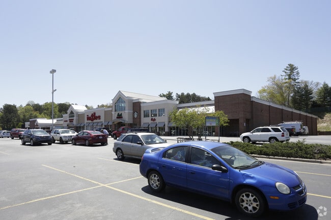
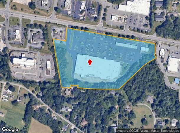
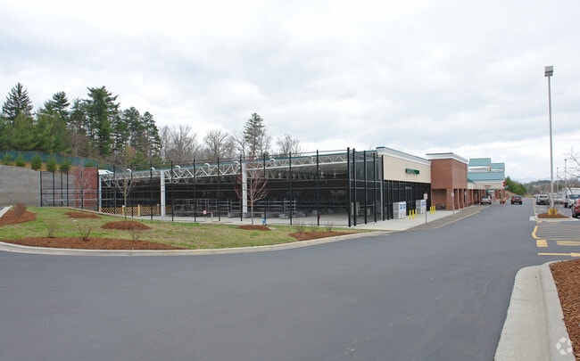
Property Record
140 Weaver Blvd, Weaverville, NC 28787
NEARBY LISTINGS FOR SALE OR LEASE
Property Detail
140 Weaver Blvd
9742-19-3699-00000
SUBDIV: BLOCK: LOT: SECTION: PLAT: 0000-0000
Supermarket
Buncombe
X
North Carolina
3700974200J
11.96 AC
2024
Buncombe County
2025
Asheville
002702
Asheville, NC
98,003 SF
DEMOGRAPHICS near 140 Weaver Blvd
1 Mile
3 Mile
5 Mile
2024 Total Population
3,521
17,445
36,498
2029 Population
3,710
18,201
38,036
Pop Growth 2024-2029
+ 5.37%
+ 4.33%
+ 4.21%
Average Age
48
46
46
2024 Total Households
1,589
7,498
15,462
HH Growth 2024-2029
+ 4.97%
+ 3.84%
+ 3.73%
Median Household Inc
$75,552
$74,426
$77,339
Avg Household Size
2.10
2.20
2.30
2024 Avg HH Vehicles
2.00
2.00
2.00
Median Home Value
$399,257
$372,517
$384,777
Median Year Built
1995
1993
1990
Nearby Places
Map Layers
Map Styles
 Street
 Aerial
- Restaurants
- Banks
- Shops
- Fitness
- Groceries
PUBLIC TRANSPORTATION
AIRPORT
Asheville Regional
DRIVE
WALK
Distance
Asheville Regional
30 min
22.5 mi
Freight Ports
North Charleston Terminal
DRIVE
WALK
Distance
North Charleston Terminal
302 min
266.2 mi
Nearby Properties
Address
Land Use
TOTAL SIZE
Lot Size
Zoning
Address
Land Use
TOTAL SIZE
Lot Size
Zoning
101,676 SF
19.40 AC
EMP
Address
Land Use
TOTAL SIZE
Lot Size
Zoning
177,630 SF
45.11 AC
OU
Address
Land Use
TOTAL SIZE
Lot Size
Zoning
70,312 SF
16.85 AC
I-1
Address
Land Use
TOTAL SIZE
Lot Size
Zoning
75,122 SF
16.91 AC
SHOPPING
Address
Land Use
TOTAL SIZE
Lot Size
Zoning
108,948 SF
24.68 AC
R-3
Address
Land Use
TOTAL SIZE
Lot Size
Zoning
64,521 SF
14.16 AC
R-3
Address
Land Use
TOTAL SIZE
Lot Size
Zoning
52,470 SF
10.50 AC
I-1
Address
Land Use
TOTAL SIZE
Lot Size
Zoning
134,304 SF
16.10 AC
C-2
Address
Land Use
TOTAL SIZE
Lot Size
Zoning
93,500 SF
60.64 AC
OU
Address
Land Use
TOTAL SIZE
Lot Size
Zoning
51,555 SF
8.34 AC
R-1
Address
Land Use
TOTAL SIZE
Lot Size
Zoning
187,648 SF
18.85 AC
I-1
Address
Land Use
TOTAL SIZE
Lot Size
Zoning
414,493 SF
34.02 AC
I-1
Address
Land Use
TOTAL SIZE
Lot Size
Zoning
139,265 SF
14.97 AC
I-1
Address
Land Use
TOTAL SIZE
Lot Size
Zoning
28,247 SF
3.22 AC
C-2
Address
Land Use
TOTAL SIZE
Lot Size
Zoning
34,646 SF
99.64 AC
OU
Address
Land Use
TOTAL SIZE
Lot Size
Zoning
47,374 SF
6.84 AC
C-2
Address
Land Use
TOTAL SIZE
Lot Size
Zoning
166,387 SF
23.84 AC
I-1
Address
Land Use
TOTAL SIZE
Lot Size
Zoning
91,988 SF
28.95 AC
R-3
Address
Land Use
TOTAL SIZE
Lot Size
Zoning
35,776 SF
13.26 AC
R-1
Address
Land Use
TOTAL SIZE
Lot Size
Zoning
23,112 SF
12.95 AC
OU
Address
Land Use
TOTAL SIZE
Lot Size
Zoning
7.54 AC
R-1
Address
Land Use
TOTAL SIZE
Lot Size
Zoning
38,346 SF
4.96 AC
R-1
Address
Land Use
TOTAL SIZE
Lot Size
Zoning
20,816 SF
3.48 AC
R-1
Address
Land Use
TOTAL SIZE
Lot Size
Zoning
37,419 SF
4.15 AC
C-2
Address
Land Use
TOTAL SIZE
Lot Size
Zoning
265,885 SF
33.47 AC
I-1
Address
Land Use
TOTAL SIZE
Lot Size
Zoning
53,760 SF
4.04 AC
R-3
Address
Land Use
TOTAL SIZE
Lot Size
Zoning
20,000 SF
5.70 AC
C-2
Address
Land Use
TOTAL SIZE
Lot Size
Zoning
30,468 SF
3.48 AC
C-2
Address
Land Use
TOTAL SIZE
Lot Size
Zoning
78,237 SF
10.07 AC
I-1
The World's #1 Commercial Real Estate Marketplace
Connect with us
© 2026 CoStar Group
The information above has been obtained from sources believed reliable. While we do not doubt its accuracy we have not verified it and make no guarantee, warranty or representation about it. It is your responsibility to independently confirm its accuracy and completeness. Any projections, opinions, assumptions, or estimates used are for example only and do not represent the current or future performance of the property. The value of this transaction to you depends on tax and other factors which should be evaluated by your tax, financial, and legal advisors. You and your advisors should conduct a careful, independent investigation of the property to determine to your satisfaction the suitability of the property for your needs.