Property Record
140 Wikiup Dr, Santa Rosa, CA 95403
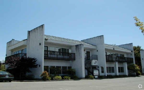

Property Detail
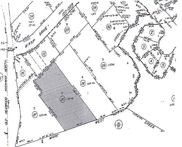
140 Wikiup Dr
039-040-028
88FM 39-040-21 CWPT22 LLA87-659 OR87113194 5 6 7 8
Officebuilding
Sonoma
CO
California
AE The base floodplain where base flood elevations are provided. AE Zones are now used on new format FIRMs instead of A1-A30 Zones.
4,5
2025
1.04 AC
2025
Santa Rosa
152701
North Bay/Santa Rosa
6,400 SF
Santa Rosa-Petaluma, CA
NEARBY LISTINGS FOR SALE OR LEASE
DEMOGRAPHICS near 140 Wikiup Dr
1 mile
3 mile
5 mile
2025 Total Population
7,189
35,447
115,587
2030 Population
7,248
35,921
116,227
Pop Growth 2025-2030
+ 0.82%
+ 1.34%
+ 0.55%
Average Age
43
43
42
2025 Total Households
2,683
13,268
42,982
HH Growth 2025-2030
+ 0.78%
+ 1.46%
+ 0.61%
Median Household Inc
$105,357
$110,230
$106,572
Avg Household Size
2.60
2.60
2.60
2025 Avg HH Vehicles
2.00
2.00
2.00
Median Home Value
$858,235
$763,842
$763,507
Median Year Built
1983
1988
1984
Nearby Places
Map Layers
Map Styles
 Street
 Aerial
Layers
 Traffic
 Biking
Places
Listings with unknown addresses are not visible on the map
- Restaurants
- Banks
- Shops
- Fitness
- Groceries
PUBLIC TRANSPORTATION
COMMUTER RAIL
Smart Santa Rosa North (Main Line - Sonoma Marin Area Rail Transit)
Drive
Walk
Distance
Smart Santa Rosa North (Main Line - Sonoma Marin Area Rail Transit)
9 min
5.7 mi
Smart Santa Rosa Downtown (Main Line - Sonoma Marin Area Rail Transit)
Drive
Walk
Distance
Smart Santa Rosa Downtown (Main Line - Sonoma Marin Area Rail Transit)
10 min
6.6 mi
AIRPORT
Charles M Schulz - Sonoma County
Drive
Walk
Distance
Charles M Schulz - Sonoma County
6 min
2.8 mi
Freight Ports
Port of Richmond
Drive
Walk
Distance
Port of Richmond
71 min
54.8 mi
Nearby Properties
Address
Land Use
TOTAL SIZE
Lot Size
Zoning
Address
Land Use
TOTAL SIZE
Lot Size
Zoning
Address
Land Use
TOTAL SIZE
Lot Size
Zoning
Address
Land Use
TOTAL SIZE
Lot Size
Zoning
280,564 SF
0.36 AC
Address
Land Use
TOTAL SIZE
Lot Size
Zoning
14.56 AC
Address
Land Use
TOTAL SIZE
Lot Size
Zoning
14,956 SF
9.77 AC
PC
Address
Land Use
TOTAL SIZE
Lot Size
Zoning
249,088 SF
10.75 AC
Address
Land Use
TOTAL SIZE
Lot Size
Zoning
1,465 SF
9.33 AC
CITYSR
Address
Land Use
TOTAL SIZE
Lot Size
Zoning
154,794 SF
15.09 AC
Address
Land Use
TOTAL SIZE
Lot Size
Zoning
184,758 SF
9.23 AC
Address
Land Use
TOTAL SIZE
Lot Size
Zoning
126,123 SF
7.66 AC
Address
Land Use
TOTAL SIZE
Lot Size
Zoning
90,330 SF
6.72 AC
Address
Land Use
TOTAL SIZE
Lot Size
Zoning
3,796 SF
9.98 AC
Address
Land Use
TOTAL SIZE
Lot Size
Zoning
119,819 SF
7.37 AC
CITYSR
Address
Land Use
TOTAL SIZE
Lot Size
Zoning
85,920 SF
5.69 AC
CITYSR
Address
Land Use
TOTAL SIZE
Lot Size
Zoning
61,796 SF
3.95 AC
Address
Land Use
TOTAL SIZE
Lot Size
Zoning
106,005 SF
10.45 AC
Address
Land Use
TOTAL SIZE
Lot Size
Zoning
58,551 SF
4.24 AC
Address
Land Use
TOTAL SIZE
Lot Size
Zoning
89,168 SF
5.50 AC
CITYSR
Address
Land Use
TOTAL SIZE
Lot Size
Zoning
60,165 SF
4.38 AC
Address
Land Use
TOTAL SIZE
Lot Size
Zoning
53,024 SF
13.82 AC
CITYSR
Address
Land Use
TOTAL SIZE
Lot Size
Zoning
93,886 SF
5.40 AC
MP2
Address
Land Use
TOTAL SIZE
Lot Size
Zoning
100,186 SF
4.31 AC
Address
Land Use
TOTAL SIZE
Lot Size
Zoning
80,017 SF
0.78 AC
Address
Land Use
TOTAL SIZE
Lot Size
Zoning
131,502 SF
8.60 AC
Address
Land Use
TOTAL SIZE
Lot Size
Zoning
14.29 AC
Address
Land Use
TOTAL SIZE
Lot Size
Zoning
232,262 SF
30.69 AC
Address
Land Use
TOTAL SIZE
Lot Size
Zoning
144,066 SF
0.52 AC
Address
Land Use
TOTAL SIZE
Lot Size
Zoning
129,726 SF
12.47 AC
Address
Land Use
TOTAL SIZE
Lot Size
Zoning
23,374 SF
30.07 AC
Address
Land Use
TOTAL SIZE
Lot Size
Zoning
70,358 SF
4.51 AC
M1
The World's #1 Commercial Real Estate Marketplace
Connect with us
© 2026 CoStar Group
The information above has been obtained from sources believed reliable. While we do not doubt its accuracy we have not verified it and make no guarantee, warranty or representation about it. It is your responsibility to independently confirm its accuracy and completeness. Any projections, opinions, assumptions, or estimates used are for example only and do not represent the current or future performance of the property. The value of this transaction to you depends on tax and other factors which should be evaluated by your tax, financial, and legal advisors. You and your advisors should conduct a careful, independent investigation of the property to determine to your satisfaction the suitability of the property for your needs.