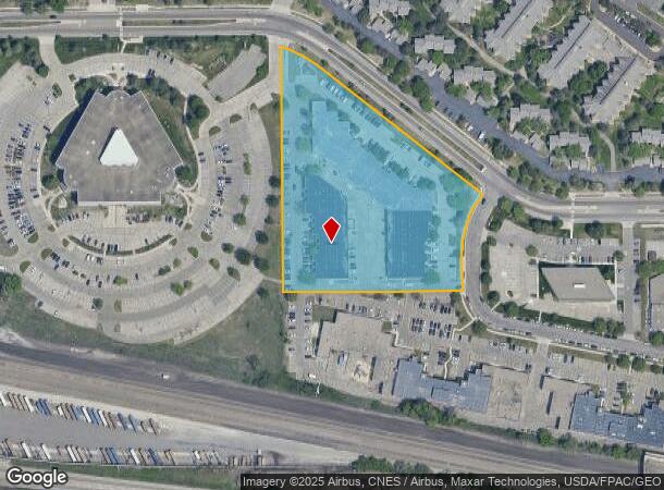
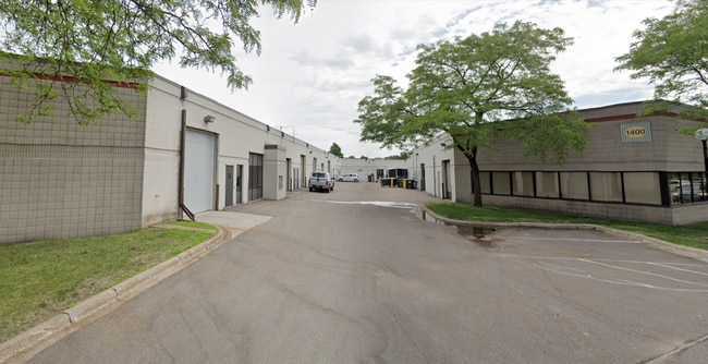
Property Record
1400 Energy Park Dr, Saint Paul, MN 55108

Current Lease Availabilities
NEARBY LISTINGS FOR SALE OR LEASE
Property Detail
1400 Energy Park Dr
Minneapolis-St. Paul-Bloomington, MN-WI
Energy Park No. 2
27-29-23-24-0305
ENERGY PARK NO. 2 SUBJ TO ESMTS; LOT 1 BLK 1
Stripcommercialcenter
Ramsey
X
Minnesota
27053C0400F
1
2024
5 AC
2025
St Paul
030202
Minneapolis/St Paul
22,632 SF
DEMOGRAPHICS near 1400 Energy Park Dr
1 Mile
3 Mile
5 Mile
2024 Total Population
15,507
152,360
416,871
2029 Population
15,083
148,385
407,585
Pop Growth 2024-2029
(2.73%)
(2.61%)
(2.23%)
Average Age
38
37
37
2024 Total Households
6,570
62,975
172,919
HH Growth 2024-2029
(2.89%)
(2.78%)
(2.29%)
Median Household Inc
$73,468
$69,594
$66,814
Avg Household Size
2.20
2.30
2.20
2024 Avg HH Vehicles
1.00
2.00
1.00
Median Home Value
$261,176
$318,264
$308,759
Median Year Built
1948
1949
1957
Nearby Places
Map Layers
Map Styles
 Street
 Aerial
- Restaurants
- Banks
- Shops
- Fitness
- Groceries
PUBLIC TRANSPORTATION
COMMUTER RAIL
DRIVE
WALK
Distance
12 min
4.7 mi
Target Field Station (Northstar Corridor - Northstar Commuter Rail)
DRIVE
WALK
Distance
Target Field Station (Northstar Corridor - Northstar Commuter Rail)
18 min
8.3 mi
AIRPORT
Minneapolis-St Paul International/Wold-Chamberlain
DRIVE
WALK
Distance
Minneapolis-St Paul International/Wold-Chamberlain
21 min
9.3 mi
Nearby Properties
Address
Land Use
TOTAL SIZE
Lot Size
Zoning
Address
Land Use
TOTAL SIZE
Lot Size
Zoning
36,300 SF
223.37 AC
Address
Land Use
TOTAL SIZE
Lot Size
Zoning
141,277 SF
44.78 AC
Address
Land Use
TOTAL SIZE
Lot Size
Zoning
84,316 SF
40.83 AC
Address
Land Use
TOTAL SIZE
Lot Size
Zoning
124,932 SF
9.68 AC
Address
Land Use
TOTAL SIZE
Lot Size
Zoning
176,108 SF
27.45 AC
Address
Land Use
TOTAL SIZE
Lot Size
Zoning
37.24 AC
Address
Land Use
TOTAL SIZE
Lot Size
Zoning
577,656 SF
2.92 AC
C3A
Address
Land Use
TOTAL SIZE
Lot Size
Zoning
404,491 SF
27.01 AC
Address
Land Use
TOTAL SIZE
Lot Size
Zoning
18.24 AC
Address
Land Use
TOTAL SIZE
Lot Size
Zoning
48.52 AC
Address
Land Use
TOTAL SIZE
Lot Size
Zoning
395,419 SF
2.73 AC
Address
Land Use
TOTAL SIZE
Lot Size
Zoning
344,458 SF
1.64 AC
C3A
Address
Land Use
TOTAL SIZE
Lot Size
Zoning
3,200 SF
0.14 AC
Address
Land Use
TOTAL SIZE
Lot Size
Zoning
516,325 SF
16.81 AC
Address
Land Use
TOTAL SIZE
Lot Size
Zoning
7.41 AC
Address
Land Use
TOTAL SIZE
Lot Size
Zoning
4,808 SF
269.81 AC
Address
Land Use
TOTAL SIZE
Lot Size
Zoning
68,748 SF
21.59 AC
Address
Land Use
TOTAL SIZE
Lot Size
Zoning
18,630 SF
22.02 AC
Address
Land Use
TOTAL SIZE
Lot Size
Zoning
518,750 SF
3.58 AC
Address
Land Use
TOTAL SIZE
Lot Size
Zoning
291,264 SF
1.61 AC
C3A
Address
Land Use
TOTAL SIZE
Lot Size
Zoning
276,144 SF
347.68 AC
Address
Land Use
TOTAL SIZE
Lot Size
Zoning
245,477 SF
1.32 AC
C3A
Address
Land Use
TOTAL SIZE
Lot Size
Zoning
200,892 SF
3.60 AC
Address
Land Use
TOTAL SIZE
Lot Size
Zoning
313,892 SF
2.03 AC
R5
Address
Land Use
TOTAL SIZE
Lot Size
Zoning
455,628 SF
2.81 AC
Address
Land Use
TOTAL SIZE
Lot Size
Zoning
251,619 SF
1.20 AC
Address
Land Use
TOTAL SIZE
Lot Size
Zoning
658,453 SF
40.22 AC
Address
Land Use
TOTAL SIZE
Lot Size
Zoning
318,765 SF
3.58 AC
Address
Land Use
TOTAL SIZE
Lot Size
Zoning
Address
Land Use
TOTAL SIZE
Lot Size
Zoning
261,098 SF
24.12 AC
The World's #1 Commercial Real Estate Marketplace
Connect with us
© 2025 CoStar Group
The information above has been obtained from sources believed reliable. While we do not doubt its accuracy we have not verified it and make no guarantee, warranty or representation about it. It is your responsibility to independently confirm its accuracy and completeness. Any projections, opinions, assumptions, or estimates used are for example only and do not represent the current or future performance of the property. The value of this transaction to you depends on tax and other factors which should be evaluated by your tax, financial, and legal advisors. You and your advisors should conduct a careful, independent investigation of the property to determine to your satisfaction the suitability of the property for your needs.