Property Record
1400 Babler Park Dr, Wildwood, MO 63038


NEARBY LISTINGS FOR SALE OR LEASE
-
-
View all Wildwood listings for sale on LoopNet.com
Property Detail
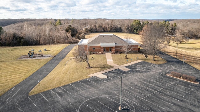
1400 Babler Park Dr
21W-31-0270
LOC AT NW CORNER OF HWY 109 & OLD EATHERTON RD 21W310023 1 2 12 90
Religious
St. Louis
X
Missouri
29071C0225E
10.43 AC
2024
West County
2025
St. Louis
221621
St. Louis, MO-IL
DEMOGRAPHICS near 1400 Babler Park Dr
1 Mile
3 Mile
5 Mile
2024 Total Population
2,342
25,251
60,676
2029 Population
2,293
24,673
59,329
Pop Growth 2024-2029
(2.09%)
(2.29%)
(2.22%)
Average Age
41
41
42
2024 Total Households
753
9,028
22,135
HH Growth 2024-2029
(2.12%)
(2.32%)
(2.26%)
Median Household Inc
$195,485
$144,382
$141,691
Avg Household Size
3.10
2.80
2.70
2024 Avg HH Vehicles
3.00
2.00
2.00
Median Home Value
$659,297
$424,669
$432,905
Median Year Built
1991
1990
1989
Nearby Places
Map Layers
Map Styles
 Street
 Aerial
- Restaurants
- Banks
- Shops
- Fitness
- Groceries
PUBLIC TRANSPORTATION
AIRPORT
St Louis Lambert International
DRIVE
WALK
Distance
St Louis Lambert International
45 min
29.0 mi
Freight Ports
Tulsa Port of Inola
DRIVE
WALK
Distance
Tulsa Port of Inola
401 min
361.9 mi
SALE & LEASE HISTORY
LISTING DATE
SALE/LEASE

Jan 09, 2023
For Sale
Nearby Properties
Address
Land Use
TOTAL SIZE
Lot Size
Zoning
Address
Land Use
TOTAL SIZE
Lot Size
Zoning
62,362 SF
2,133.73 AC
PS
Address
Land Use
TOTAL SIZE
Lot Size
Zoning
51.20 AC
NU
Address
Land Use
TOTAL SIZE
Lot Size
Zoning
85,946 SF
60.44 AC
NU
Address
Land Use
TOTAL SIZE
Lot Size
Zoning
313,104 SF
14.66 AC
MXD
Address
Land Use
TOTAL SIZE
Lot Size
Zoning
138,056 SF
17.42 AC
NU
Address
Land Use
TOTAL SIZE
Lot Size
Zoning
68.69 AC
107NU
Address
Land Use
TOTAL SIZE
Lot Size
Zoning
30 AC
107NU
Address
Land Use
TOTAL SIZE
Lot Size
Zoning
16.80 AC
NU
Address
Land Use
TOTAL SIZE
Lot Size
Zoning
164,430 SF
9.85 AC
19C-4
Address
Land Use
TOTAL SIZE
Lot Size
Zoning
4,464 SF
12.30 AC
107NU
Address
Land Use
TOTAL SIZE
Lot Size
Zoning
84.04 AC
107PS
Address
Land Use
TOTAL SIZE
Lot Size
Zoning
185,087 SF
8 AC
19C-4
Address
Land Use
TOTAL SIZE
Lot Size
Zoning
118,097 SF
14.32 AC
19C-4
Address
Land Use
TOTAL SIZE
Lot Size
Zoning
109,550 SF
14.21 AC
107R6A
Address
Land Use
TOTAL SIZE
Lot Size
Zoning
7,208 SF
29.36 AC
107NU
Address
Land Use
TOTAL SIZE
Lot Size
Zoning
72.37 AC
107PS
Address
Land Use
TOTAL SIZE
Lot Size
Zoning
11.91 AC
107R3
Address
Land Use
TOTAL SIZE
Lot Size
Zoning
73,053 SF
1.65 AC
107NU
Address
Land Use
TOTAL SIZE
Lot Size
Zoning
50,846 SF
6.52 AC
107NU
Address
Land Use
TOTAL SIZE
Lot Size
Zoning
15.82 AC
107NU
Address
Land Use
TOTAL SIZE
Lot Size
Zoning
89,832 SF
10.68 AC
19C-4
Address
Land Use
TOTAL SIZE
Lot Size
Zoning
42,657 SF
5.86 AC
19C-4
Address
Land Use
TOTAL SIZE
Lot Size
Zoning
26,917 SF
5.37 AC
107NU
Address
Land Use
TOTAL SIZE
Lot Size
Zoning
1,836 SF
14.46 AC
107NU
Address
Land Use
TOTAL SIZE
Lot Size
Zoning
102,071 SF
5.03 AC
19C-4
Address
Land Use
TOTAL SIZE
Lot Size
Zoning
62,214 SF
4.13 AC
19C-4
Address
Land Use
TOTAL SIZE
Lot Size
Zoning
13.09 AC
107NU
Address
Land Use
TOTAL SIZE
Lot Size
Zoning
10.32 AC
FPNU
Address
Land Use
TOTAL SIZE
Lot Size
Zoning
21.44 AC
107PS
Address
Land Use
TOTAL SIZE
Lot Size
Zoning
35.82 AC
107NU
The World's #1 Commercial Real Estate Marketplace
Connect with us
© 2026 CoStar Group
The information above has been obtained from sources believed reliable. While we do not doubt its accuracy we have not verified it and make no guarantee, warranty or representation about it. It is your responsibility to independently confirm its accuracy and completeness. Any projections, opinions, assumptions, or estimates used are for example only and do not represent the current or future performance of the property. The value of this transaction to you depends on tax and other factors which should be evaluated by your tax, financial, and legal advisors. You and your advisors should conduct a careful, independent investigation of the property to determine to your satisfaction the suitability of the property for your needs.