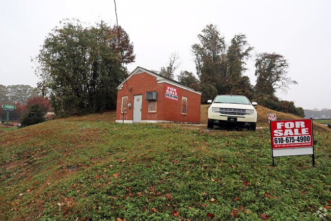
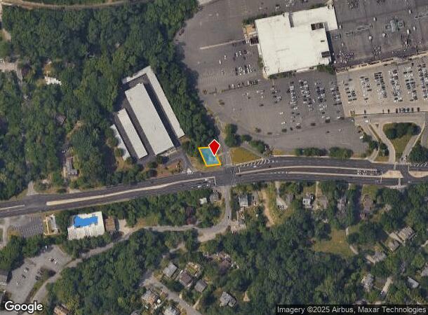
Property Record
1400 Baltimore Pike, Springfield, PA 19064

NEARBY LISTINGS FOR SALE OR LEASE
Property Detail
1400 Baltimore Pike
Philadelphia-Camden-Wilmington, PA-NJ-DE-MD
American Telephone & Telegraph
42-00-00496-01
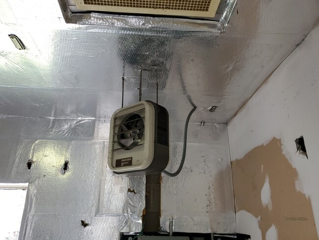
1 STY BLDG .105AC
Utilities
Delaware
X
Pennsylvania
42045C0111F
0.11 AC
2024
Delaware County
2025
Philadelphia
407802
DEMOGRAPHICS near 1400 Baltimore Pike
1 Mile
3 Mile
5 Mile
2024 Total Population
7,429
115,511
329,384
2029 Population
7,335
114,374
326,639
Pop Growth 2024-2029
(1.27%)
(0.98%)
(0.83%)
Average Age
42
41
40
2024 Total Households
2,660
44,820
125,969
HH Growth 2024-2029
(1.43%)
(1.01%)
(0.90%)
Median Household Inc
$132,697
$99,256
$79,039
Avg Household Size
2.60
2.50
2.50
2024 Avg HH Vehicles
2.00
2.00
2.00
Median Home Value
$437,742
$307,591
$259,126
Median Year Built
1954
1956
1955
Nearby Places
Map Layers
Map Styles
 Street
 Aerial
- Restaurants
- Banks
- Shops
- Fitness
- Groceries
PUBLIC TRANSPORTATION
TRANSIT/SUBWAY
Paper Mill Road (Route 101 - Southeastern Pennsylvania Transportation Authority Rapid Transit (SEPTA Subway & Trolley))
DRIVE
WALK
Distance
Paper Mill Road (Route 101 - Southeastern Pennsylvania Transportation Authority Rapid Transit (SEPTA Subway & Trolley))
0 min
6 min
0.3 mi
Paper Mill Rd (Route 101 - SEPTA)
DRIVE
WALK
Distance
Paper Mill Rd (Route 101 - SEPTA)
1 min
6 min
0.3 mi
Springfield Mall Station (Route 101 - SEPTA)
DRIVE
WALK
Distance
Springfield Mall Station (Route 101 - SEPTA)
1 min
10 min
0.6 mi
96 Signal - Not A Stop (Route 101 - SEPTA)
DRIVE
WALK
Distance
96 Signal - Not A Stop (Route 101 - SEPTA)
2 min
14 min
0.8 mi
Thomson Avenue (Route 101 - SEPTA)
DRIVE
WALK
Distance
Thomson Avenue (Route 101 - SEPTA)
2 min
17 min
0.9 mi
COMMUTER RAIL
Swarthmore (R3 - Southeastern Pennsylvania Transportation Authority Regional Rail (SEPTA Regional Rail))
DRIVE
WALK
Distance
Swarthmore (R3 - Southeastern Pennsylvania Transportation Authority Regional Rail (SEPTA Regional Rail))
3 min
20 min
1.0 mi
Wallingford (R3 - Southeastern Pennsylvania Transportation Authority Regional Rail (SEPTA Regional Rail))
DRIVE
WALK
Distance
Wallingford (R3 - Southeastern Pennsylvania Transportation Authority Regional Rail (SEPTA Regional Rail))
3 min
1.6 mi
AIRPORT
Philadelphia International
DRIVE
WALK
Distance
Philadelphia International
16 min
9.7 mi
Freight Ports
South Jersey Port
DRIVE
WALK
Distance
South Jersey Port
34 min
22.0 mi
SALE & LEASE HISTORY
LISTING DATE
SALE/LEASE

Oct 31, 2019
For Sale
Oct 01, 2024
For Sale
Nov 14, 2017
For Sale
Nearby Properties
Address
Land Use
TOTAL SIZE
Lot Size
Zoning
Address
Land Use
TOTAL SIZE
Lot Size
Zoning
6,637 SF
198.92 AC
Address
Land Use
TOTAL SIZE
Lot Size
Zoning
280,591 SF
2.76 AC
Address
Land Use
TOTAL SIZE
Lot Size
Zoning
48,739 SF
30 AC
Address
Land Use
TOTAL SIZE
Lot Size
Zoning
345,135 SF
37 AC
Address
Land Use
TOTAL SIZE
Lot Size
Zoning
175,000 SF
2.27 AC
Address
Land Use
TOTAL SIZE
Lot Size
Zoning
702,532 SF
11 AC
Address
Land Use
TOTAL SIZE
Lot Size
Zoning
20,880 SF
27.20 AC
Address
Land Use
TOTAL SIZE
Lot Size
Zoning
6,040 SF
16.45 AC
Address
Land Use
TOTAL SIZE
Lot Size
Zoning
241,578 SF
14 AC
Address
Land Use
TOTAL SIZE
Lot Size
Zoning
136,972 SF
27 AC
Address
Land Use
TOTAL SIZE
Lot Size
Zoning
312,988 SF
24 AC
Address
Land Use
TOTAL SIZE
Lot Size
Zoning
255,316 SF
6 AC
Address
Land Use
TOTAL SIZE
Lot Size
Zoning
61,860 SF
6.29 AC
Address
Land Use
TOTAL SIZE
Lot Size
Zoning
2,608 SF
198.92 AC
Address
Land Use
TOTAL SIZE
Lot Size
Zoning
2,562 SF
198.92 AC
Address
Land Use
TOTAL SIZE
Lot Size
Zoning
170,442 SF
26.04 AC
Address
Land Use
TOTAL SIZE
Lot Size
Zoning
12,100 SF
7 AC
Address
Land Use
TOTAL SIZE
Lot Size
Zoning
215,557 SF
22 AC
Address
Land Use
TOTAL SIZE
Lot Size
Zoning
261,618 SF
30.57 AC
Address
Land Use
TOTAL SIZE
Lot Size
Zoning
13,932 SF
9 AC
Address
Land Use
TOTAL SIZE
Lot Size
Zoning
702,532 SF
Address
Land Use
TOTAL SIZE
Lot Size
Zoning
229,612 SF
6.05 AC
Address
Land Use
TOTAL SIZE
Lot Size
Zoning
76,600 SF
16.90 AC
Address
Land Use
TOTAL SIZE
Lot Size
Zoning
282,520 SF
24.44 AC
Address
Land Use
TOTAL SIZE
Lot Size
Zoning
86,052 SF
7.63 AC
Address
Land Use
TOTAL SIZE
Lot Size
Zoning
24,362 SF
5.63 AC
Address
Land Use
TOTAL SIZE
Lot Size
Zoning
64,280 SF
24 AC
Address
Land Use
TOTAL SIZE
Lot Size
Zoning
187,056 SF
16 AC
Address
Land Use
TOTAL SIZE
Lot Size
Zoning
164,834 SF
13 AC
Address
Land Use
TOTAL SIZE
Lot Size
Zoning
147,264 SF
29.71 AC
The World's #1 Commercial Real Estate Marketplace
Connect with us
© 2025 CoStar Group
The information above has been obtained from sources believed reliable. While we do not doubt its accuracy we have not verified it and make no guarantee, warranty or representation about it. It is your responsibility to independently confirm its accuracy and completeness. Any projections, opinions, assumptions, or estimates used are for example only and do not represent the current or future performance of the property. The value of this transaction to you depends on tax and other factors which should be evaluated by your tax, financial, and legal advisors. You and your advisors should conduct a careful, independent investigation of the property to determine to your satisfaction the suitability of the property for your needs.