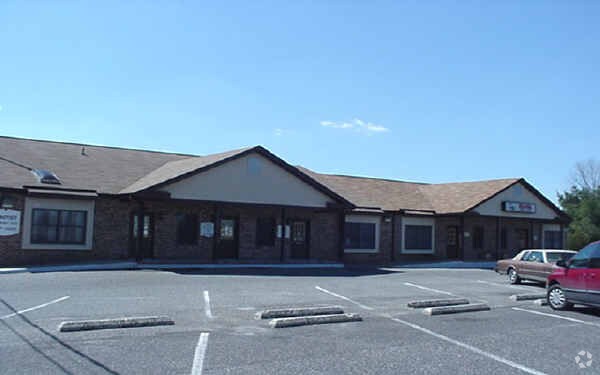
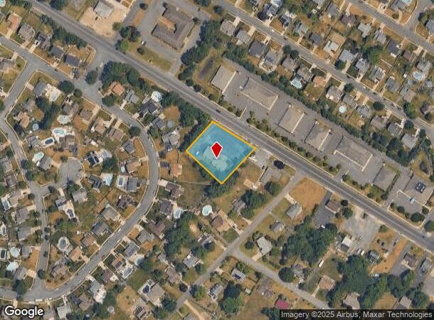
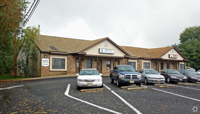
Property Record
1400 Chews Landing Rd, Laurel Spgs, NJ 08021

NEARBY LISTINGS FOR SALE OR LEASE
Property Detail
1400 Chews Landing Rd
15-08206-0000-00006
Camden
Commercialnec
New Jersey
X
6
34007C0108E
0.98 AC
2024
South Camden County
2025
Philadelphia
608600
Philadelphia-Camden-Wilmington, PA-NJ-DE-MD
DEMOGRAPHICS near 1400 Chews Landing Rd
1 Mile
3 Mile
5 Mile
2024 Total Population
8,707
95,228
230,297
2029 Population
8,620
95,035
230,848
Pop Growth 2024-2029
(1.00%)
(0.20%)
+ 0.24%
Average Age
43
40
41
2024 Total Households
3,550
38,482
91,358
HH Growth 2024-2029
(0.99%)
(0.27%)
+ 0.18%
Median Household Inc
$100,187
$79,831
$84,535
Avg Household Size
2.40
2.40
2.50
2024 Avg HH Vehicles
2.00
2.00
2.00
Median Home Value
$244,614
$218,267
$242,544
Median Year Built
1976
1969
1970
Nearby Places
Map Layers
Map Styles
 Street
 Aerial
- Restaurants
- Banks
- Shops
- Fitness
- Groceries
PUBLIC TRANSPORTATION
COMMUTER RAIL
Lindenwold (NJT) (Atlantic City Line - NJ Transit Commuter Rail (NJ Transit))
DRIVE
WALK
Distance
Lindenwold (NJT) (Atlantic City Line - NJ Transit Commuter Rail (NJ Transit))
8 min
3.8 mi
AIRPORT
Philadelphia International
DRIVE
WALK
Distance
Philadelphia International
32 min
17.8 mi
Atlantic City International
DRIVE
WALK
Distance
Atlantic City International
74 min
43.1 mi
Trenton Mercer
DRIVE
WALK
Distance
Trenton Mercer
63 min
44.9 mi
Freight Ports
Broadway Terminal - Pier 5
DRIVE
WALK
Distance
Broadway Terminal - Pier 5
16 min
9.3 mi
Nearby Properties
Address
Land Use
TOTAL SIZE
Lot Size
Zoning
Address
Land Use
TOTAL SIZE
Lot Size
Zoning
23.41 AC
BC2
Address
Land Use
TOTAL SIZE
Lot Size
Zoning
Address
Land Use
TOTAL SIZE
Lot Size
Zoning
54.91 AC
Address
Land Use
TOTAL SIZE
Lot Size
Zoning
Address
Land Use
TOTAL SIZE
Lot Size
Zoning
61.94 AC
R3
Address
Land Use
TOTAL SIZE
Lot Size
Zoning
46,360 SF
8.07 AC
Address
Land Use
TOTAL SIZE
Lot Size
Zoning
48 AC
R-3
Address
Land Use
TOTAL SIZE
Lot Size
Zoning
40.92 AC
BC2
Address
Land Use
TOTAL SIZE
Lot Size
Zoning
Address
Land Use
TOTAL SIZE
Lot Size
Zoning
49.56 AC
H
Address
Land Use
TOTAL SIZE
Lot Size
Zoning
33.50 AC
INS
Address
Land Use
TOTAL SIZE
Lot Size
Zoning
34.62 AC
Address
Land Use
TOTAL SIZE
Lot Size
Zoning
32.49 AC
Address
Land Use
TOTAL SIZE
Lot Size
Zoning
33.24 AC
INS
Address
Land Use
TOTAL SIZE
Lot Size
Zoning
Address
Land Use
TOTAL SIZE
Lot Size
Zoning
67.33 AC
BC2
Address
Land Use
TOTAL SIZE
Lot Size
Zoning
29.87 AC
R-3
Address
Land Use
TOTAL SIZE
Lot Size
Zoning
332,344 SF
11.99 AC
R10
Address
Land Use
TOTAL SIZE
Lot Size
Zoning
41.09 AC
Address
Land Use
TOTAL SIZE
Lot Size
Zoning
Address
Land Use
TOTAL SIZE
Lot Size
Zoning
28.93 AC
Address
Land Use
TOTAL SIZE
Lot Size
Zoning
3.50 AC
Address
Land Use
TOTAL SIZE
Lot Size
Zoning
15.96 AC
BC2
Address
Land Use
TOTAL SIZE
Lot Size
Zoning
5.29 AC
Address
Land Use
TOTAL SIZE
Lot Size
Zoning
17.27 AC
Address
Land Use
TOTAL SIZE
Lot Size
Zoning
14.49 AC
BC2
Address
Land Use
TOTAL SIZE
Lot Size
Zoning
Address
Land Use
TOTAL SIZE
Lot Size
Zoning
1,872 SF
180.40 AC
Address
Land Use
TOTAL SIZE
Lot Size
Zoning
8.58 AC
BC2
Address
Land Use
TOTAL SIZE
Lot Size
Zoning
30.37 AC
RA
The World's #1 Commercial Real Estate Marketplace
Connect with us
© 2025 CoStar Group
The information above has been obtained from sources believed reliable. While we do not doubt its accuracy we have not verified it and make no guarantee, warranty or representation about it. It is your responsibility to independently confirm its accuracy and completeness. Any projections, opinions, assumptions, or estimates used are for example only and do not represent the current or future performance of the property. The value of this transaction to you depends on tax and other factors which should be evaluated by your tax, financial, and legal advisors. You and your advisors should conduct a careful, independent investigation of the property to determine to your satisfaction the suitability of the property for your needs.