Property Record
1400 E Inman Pkwy, Beloit, WI 53511
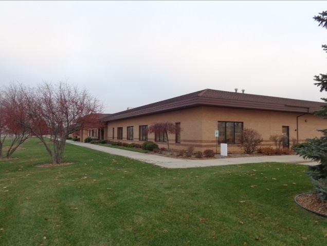

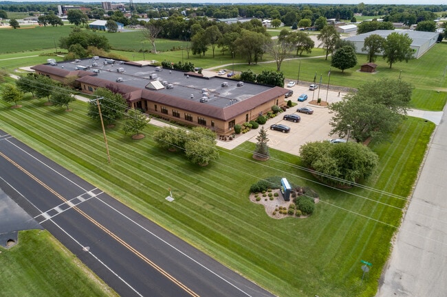
Property Detail
1400 E Inman Pkwy
Janesville-Beloit, WI
PT NE1/4 NE1/4 & PT NW1/4 NE1/4 PT OL 13-1 AP CERTIFIED SURVEY MAP #2036674 VOL 37 PG 69-71 LOT 1
111-059006
ROCK
Manufacturinglight
Wisconsin
B and X Area of moderate flood hazard, usually the area between the limits of the 100-year and 500-year floods.
1
2025
5.31 AC
2025
Rock County
002400
Milwaukee/Madison
2,204 SF
NEARBY LISTINGS FOR SALE OR LEASE
-
-
View all Beloit listings for lease on LoopNet.com
DEMOGRAPHICS near 1400 E Inman Pkwy
1 mile
3 mile
5 mile
2025 Total Population
5,181
24,473
53,753
2030 Population
5,248
24,650
54,266
Pop Growth 2025-2030
+ 1.29%
+ 0.72%
+ 0.95%
Average Age
45
42
40
2025 Total Households
2,227
9,931
21,106
HH Growth 2025-2030
+ 1.30%
+ 0.69%
+ 0.97%
Median Household Inc
$83,509
$67,594
$64,848
Avg Household Size
2.30
2.40
2.40
2025 Avg HH Vehicles
2.00
2.00
2.00
Median Home Value
$238,392
$205,510
$182,916
Median Year Built
1981
1966
1962
Nearby Places
Map Layers
Map Styles
 Street
 Aerial
Layers
 Traffic
 Biking
Places
Listings with unknown addresses are not visible on the map
- Restaurants
- Banks
- Shops
- Fitness
- Groceries
PUBLIC TRANSPORTATION
AIRPORT
Chicago/Rockford International
Drive
Walk
Distance
Chicago/Rockford International
49 min
36.6 mi
SALE & LEASE HISTORY
LISTING DATE
SALE/LEASE

Feb 24, 2017
For Sale
Dec 12, 2024
For Lease
Nearby Properties
Address
Land Use
TOTAL SIZE
Lot Size
Zoning
Address
Land Use
TOTAL SIZE
Lot Size
Zoning
37.49 AC
CHI
Address
Land Use
TOTAL SIZE
Lot Size
Zoning
24.76 AC
Address
Land Use
TOTAL SIZE
Lot Size
Zoning
61,820 SF
5.63 AC
Address
Land Use
TOTAL SIZE
Lot Size
Zoning
103,761 SF
21.59 AC
Address
Land Use
TOTAL SIZE
Lot Size
Zoning
7.71 AC
Address
Land Use
TOTAL SIZE
Lot Size
Zoning
3.65 AC
Address
Land Use
TOTAL SIZE
Lot Size
Zoning
90.81 AC
Address
Land Use
TOTAL SIZE
Lot Size
Zoning
231,166 SF
19.25 AC
Address
Land Use
TOTAL SIZE
Lot Size
Zoning
361,947 SF
23.26 AC
Address
Land Use
TOTAL SIZE
Lot Size
Zoning
193,013 SF
22.93 AC
Address
Land Use
TOTAL SIZE
Lot Size
Zoning
38,012 SF
2.74 AC
Address
Land Use
TOTAL SIZE
Lot Size
Zoning
40,800 SF
81.29 AC
Address
Land Use
TOTAL SIZE
Lot Size
Zoning
9,208 SF
10.33 AC
Address
Land Use
TOTAL SIZE
Lot Size
Zoning
30,000 SF
3.31 AC
Address
Land Use
TOTAL SIZE
Lot Size
Zoning
87.39 AC
MHP
Address
Land Use
TOTAL SIZE
Lot Size
Zoning
101,660 SF
10.14 AC
Address
Land Use
TOTAL SIZE
Lot Size
Zoning
16,336 SF
9.06 AC
Address
Land Use
TOTAL SIZE
Lot Size
Zoning
3.30 AC
Address
Land Use
TOTAL SIZE
Lot Size
Zoning
20.18 AC
Address
Land Use
TOTAL SIZE
Lot Size
Zoning
296,731 SF
18.14 AC
Address
Land Use
TOTAL SIZE
Lot Size
Zoning
11.62 AC
Address
Land Use
TOTAL SIZE
Lot Size
Zoning
90,285 SF
4.24 AC
Address
Land Use
TOTAL SIZE
Lot Size
Zoning
95,546 SF
8.60 AC
Address
Land Use
TOTAL SIZE
Lot Size
Zoning
2.98 AC
Address
Land Use
TOTAL SIZE
Lot Size
Zoning
13.70 AC
Address
Land Use
TOTAL SIZE
Lot Size
Zoning
57,512 SF
1.62 AC
Address
Land Use
TOTAL SIZE
Lot Size
Zoning
7.57 AC
Address
Land Use
TOTAL SIZE
Lot Size
Zoning
76,570 SF
6.74 AC
Address
Land Use
TOTAL SIZE
Lot Size
Zoning
264,754 SF
6.49 AC
Address
Land Use
TOTAL SIZE
Lot Size
Zoning
82,412 SF
3.94 AC
The World's #1 Commercial Real Estate Marketplace
Connect with us
© 2026 CoStar Group
The information above has been obtained from sources believed reliable. While we do not doubt its accuracy we have not verified it and make no guarantee, warranty or representation about it. It is your responsibility to independently confirm its accuracy and completeness. Any projections, opinions, assumptions, or estimates used are for example only and do not represent the current or future performance of the property. The value of this transaction to you depends on tax and other factors which should be evaluated by your tax, financial, and legal advisors. You and your advisors should conduct a careful, independent investigation of the property to determine to your satisfaction the suitability of the property for your needs.