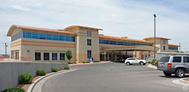
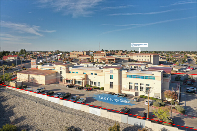
Property Record
1400 George Dieter Dr, El Paso, TX 79936


NEARBY LISTINGS FOR SALE OR LEASE
Property Detail
1400 George Dieter Dr
S700-999-0090-0175
Stone Ridge Unit 1
Commercialnec
9 STONE RIDGE #4 SLY PT OF 2 (211.43 FT ON ST- IRREG ON NLY- IRREG ON ELY- 390.64 FT ON SLY) (155818.48 SQ FT)
X
El Paso
4802140045C
Texas
2024
3.58 AC
2025
East
004316
El Paso
46,609 SF
El Paso, TX
DEMOGRAPHICS near 1400 George Dieter Dr
1 Mile
3 Mile
5 Mile
2024 Total Population
10,866
109,563
287,870
2029 Population
11,010
110,229
290,221
Pop Growth 2024-2029
+ 1.33%
+ 0.61%
+ 0.82%
Average Age
38
38
37
2024 Total Households
3,962
38,616
98,866
HH Growth 2024-2029
+ 1.36%
+ 0.64%
+ 0.81%
Median Household Inc
$58,161
$54,314
$53,599
Avg Household Size
2.70
2.80
2.90
2024 Avg HH Vehicles
2.00
2.00
2.00
Median Home Value
$155,925
$156,257
$152,248
Median Year Built
1987
1986
1986
Nearby Places
Map Layers
Map Styles
 Street
 Aerial
- Restaurants
- Banks
- Shops
- Fitness
- Groceries
PUBLIC TRANSPORTATION
AIRPORT
El Paso International
DRIVE
WALK
Distance
El Paso International
22 min
9.7 mi
Freight Ports
Port of Corpus Christi
DRIVE
WALK
Distance
Port of Corpus Christi
668 min
683.7 mi
SALE & LEASE HISTORY
LISTING DATE
SALE/LEASE

May 07, 2019
For Lease
Nearby Properties
Address
Land Use
TOTAL SIZE
Lot Size
Zoning
Address
Land Use
TOTAL SIZE
Lot Size
Zoning
555,120 SF
36.68 AC
Address
Land Use
TOTAL SIZE
Lot Size
Zoning
306,059 SF
15.01 AC
C3
Address
Land Use
TOTAL SIZE
Lot Size
Zoning
260,501 SF
14.05 AC
A2
Address
Land Use
TOTAL SIZE
Lot Size
Zoning
195,977 SF
9.77 AC
C4
Address
Land Use
TOTAL SIZE
Lot Size
Zoning
205,189 SF
22.92 AC
C4
Address
Land Use
TOTAL SIZE
Lot Size
Zoning
463,000 SF
24.75 AC
C4
Address
Land Use
TOTAL SIZE
Lot Size
Zoning
214,837 SF
9.44 AC
AO
Address
Land Use
TOTAL SIZE
Lot Size
Zoning
80,049 SF
8.90 AC
C4
Address
Land Use
TOTAL SIZE
Lot Size
Zoning
235,670 SF
10 AC
A3C
Address
Land Use
TOTAL SIZE
Lot Size
Zoning
118,114 SF
13.80 AC
C4S
Address
Land Use
TOTAL SIZE
Lot Size
Zoning
202,253 SF
10.70 AC
A2
Address
Land Use
TOTAL SIZE
Lot Size
Zoning
307,300 SF
17.47 AC
Address
Land Use
TOTAL SIZE
Lot Size
Zoning
166,671 SF
24.61 AC
C4S
Address
Land Use
TOTAL SIZE
Lot Size
Zoning
321,764 SF
18.61 AC
C4
Address
Land Use
TOTAL SIZE
Lot Size
Zoning
209,006 SF
18.18 AC
C4
Address
Land Use
TOTAL SIZE
Lot Size
Zoning
274,580 SF
13.86 AC
C4S
Address
Land Use
TOTAL SIZE
Lot Size
Zoning
230,152 SF
14.09 AC
C4S
Address
Land Use
TOTAL SIZE
Lot Size
Zoning
192,261 SF
8.07 AC
A3C
Address
Land Use
TOTAL SIZE
Lot Size
Zoning
106,261 SF
3 AC
R3
Address
Land Use
TOTAL SIZE
Lot Size
Zoning
269,370 SF
17.88 AC
Address
Land Use
TOTAL SIZE
Lot Size
Zoning
246,136 SF
15.68 AC
Address
Land Use
TOTAL SIZE
Lot Size
Zoning
246,136 SF
14.33 AC
Address
Land Use
TOTAL SIZE
Lot Size
Zoning
206,726 SF
24.42 AC
M1S
Address
Land Use
TOTAL SIZE
Lot Size
Zoning
154,016 SF
8.05 AC
A2
Address
Land Use
TOTAL SIZE
Lot Size
Zoning
111,558 SF
16.25 AC
C4
Address
Land Use
TOTAL SIZE
Lot Size
Zoning
174,863 SF
15.28 AC
C4
Address
Land Use
TOTAL SIZE
Lot Size
Zoning
259,968 SF
10.54 AC
AO
Address
Land Use
TOTAL SIZE
Lot Size
Zoning
173,471 SF
13.29 AC
C4
Address
Land Use
TOTAL SIZE
Lot Size
Zoning
281,279 SF
14.74 AC
C4
The World's #1 Commercial Real Estate Marketplace
Connect with us
© 2026 CoStar Group
The information above has been obtained from sources believed reliable. While we do not doubt its accuracy we have not verified it and make no guarantee, warranty or representation about it. It is your responsibility to independently confirm its accuracy and completeness. Any projections, opinions, assumptions, or estimates used are for example only and do not represent the current or future performance of the property. The value of this transaction to you depends on tax and other factors which should be evaluated by your tax, financial, and legal advisors. You and your advisors should conduct a careful, independent investigation of the property to determine to your satisfaction the suitability of the property for your needs.