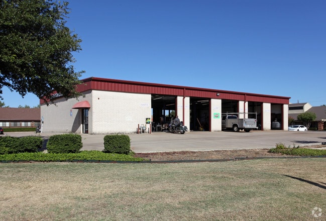
Property Record
1400 Mac Arthur Dr, Carrollton, TX 75007


NEARBY LISTINGS FOR SALE OR LEASE
Property Detail
1400 Mac Arthur Dr
Dallas-Fort Worth-Arlington, TX
William R Melton
14059250010010000
WILLIAM R MELTON BLK 1 LT 1 LESS ROW ACS 0.768 VOL95245/3680 DD121895 CO-DALLAS 0592500100100 11405925001
Autorepair
Dallas
X
Texas
48113C0160K
1
2024
0.77 AC
2025
North Carrollton
013719
Dallas/Ft Worth
5,520 SF
DEMOGRAPHICS near 1400 Mac Arthur Dr
1 Mile
3 Mile
5 Mile
2024 Total Population
6,045
97,629
310,419
2029 Population
6,731
108,559
344,640
Pop Growth 2024-2029
+ 11.35%
+ 11.20%
+ 11.02%
Average Age
44
39
38
2024 Total Households
2,317
36,163
123,844
HH Growth 2024-2029
+ 10.96%
+ 11.60%
+ 11.67%
Median Household Inc
$100,980
$89,878
$83,348
Avg Household Size
2.60
2.60
2.50
2024 Avg HH Vehicles
2.00
2.00
2.00
Median Home Value
$354,758
$323,537
$348,507
Median Year Built
1987
1988
1990
Nearby Places
Map Layers
Map Styles
 Street
 Aerial
- Restaurants
- Banks
- Shops
- Fitness
- Groceries
PUBLIC TRANSPORTATION
COMMUTER RAIL
Trinity Mills Station (Green Line - Dallas Area Rapid Transit (DART))
DRIVE
WALK
Distance
Trinity Mills Station (Green Line - Dallas Area Rapid Transit (DART))
2 min
13 min
0.6 mi
DRIVE
WALK
Distance
8 min
3.7 mi
AIRPORT
Dallas-Fort Worth International
DRIVE
WALK
Distance
Dallas-Fort Worth International
19 min
13.5 mi
Dallas Love Field
DRIVE
WALK
Distance
Dallas Love Field
25 min
15.3 mi
Nearby Properties
Address
Land Use
TOTAL SIZE
Lot Size
Zoning
Address
Land Use
TOTAL SIZE
Lot Size
Zoning
660,180 SF
29.95 AC
Address
Land Use
TOTAL SIZE
Lot Size
Zoning
462,692 SF
30.77 AC
2G
Address
Land Use
TOTAL SIZE
Lot Size
Zoning
452,167 SF
5.80 AC
Address
Land Use
TOTAL SIZE
Lot Size
Zoning
513,871 SF
3.63 AC
Z235
Address
Land Use
TOTAL SIZE
Lot Size
Zoning
242,707 SF
27.63 AC
Z343
Address
Land Use
TOTAL SIZE
Lot Size
Zoning
368,845 SF
20.96 AC
Z172
Address
Land Use
TOTAL SIZE
Lot Size
Zoning
321,732 SF
4.05 AC
Z235
Address
Land Use
TOTAL SIZE
Lot Size
Zoning
343,234 SF
32.41 AC
Address
Land Use
TOTAL SIZE
Lot Size
Zoning
354,546 SF
19.38 AC
3B
Address
Land Use
TOTAL SIZE
Lot Size
Zoning
345,320 SF
20.50 AC
Z172
Address
Land Use
TOTAL SIZE
Lot Size
Zoning
266,871 SF
87 SF
Address
Land Use
TOTAL SIZE
Lot Size
Zoning
725,972 SF
4 AC
Address
Land Use
TOTAL SIZE
Lot Size
Zoning
189,500 SF
53.90 AC
Address
Land Use
TOTAL SIZE
Lot Size
Zoning
297,932 SF
14.05 AC
Address
Land Use
TOTAL SIZE
Lot Size
Zoning
283,285 SF
16.80 AC
Z172
Address
Land Use
TOTAL SIZE
Lot Size
Zoning
397,889 SF
23.14 AC
2A
Address
Land Use
TOTAL SIZE
Lot Size
Zoning
270,915 SF
3.91 AC
Z84
Address
Land Use
TOTAL SIZE
Lot Size
Zoning
711,360 SF
32.62 AC
Address
Land Use
TOTAL SIZE
Lot Size
Zoning
350,002 SF
21.01 AC
Z172
Address
Land Use
TOTAL SIZE
Lot Size
Zoning
228,674 SF
11.81 AC
Z235
Address
Land Use
TOTAL SIZE
Lot Size
Zoning
294,764 SF
18 AC
Address
Land Use
TOTAL SIZE
Lot Size
Zoning
276,509 SF
16.67 AC
2G
Address
Land Use
TOTAL SIZE
Lot Size
Zoning
385,026 SF
7.46 AC
Address
Land Use
TOTAL SIZE
Lot Size
Zoning
310,696 SF
13.35 AC
2B
Address
Land Use
TOTAL SIZE
Lot Size
Zoning
288,278 SF
16.16 AC
2G
Address
Land Use
TOTAL SIZE
Lot Size
Zoning
219,057 SF
12.63 AC
2B
Address
Land Use
TOTAL SIZE
Lot Size
Zoning
232,109 SF
4.38 AC
Address
Land Use
TOTAL SIZE
Lot Size
Zoning
220,681 SF
13.97 AC
2B
Address
Land Use
TOTAL SIZE
Lot Size
Zoning
171,826 SF
12.49 AC
Z235
Address
Land Use
TOTAL SIZE
Lot Size
Zoning
175,000 SF
20.50 AC
The World's #1 Commercial Real Estate Marketplace
Connect with us
© 2025 CoStar Group
The information above has been obtained from sources believed reliable. While we do not doubt its accuracy we have not verified it and make no guarantee, warranty or representation about it. It is your responsibility to independently confirm its accuracy and completeness. Any projections, opinions, assumptions, or estimates used are for example only and do not represent the current or future performance of the property. The value of this transaction to you depends on tax and other factors which should be evaluated by your tax, financial, and legal advisors. You and your advisors should conduct a careful, independent investigation of the property to determine to your satisfaction the suitability of the property for your needs.