Property Record
1400 Ormond Rd, White Lake, MI 48383
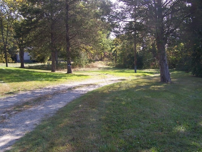
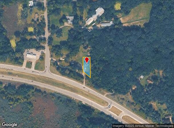
This Property Is For Sale
NEARBY LISTINGS FOR SALE OR LEASE
Property Detail
1400 Ormond Rd
12-19-201-003
T3N, R8E, SEC 19 PART OF NE 1/4 BEG AT PT DIST S 01-03-50 W 315.89 FT & S 73-00-40 E 453.79 FT FROM N 1/4 COR, TH ALG CURVE TO LEFT, RAD 500 FT, CHORD BEARS N 51-22-50 W 93.81 FT, TH N 01-59-00 E 150 FT, TH S 88-01-00 E 75 FT, TH S 01-59-00 W 205.76
Sfr
Oakland
X
Michigan
26125C0318F
0.35 AC
2024
St Clair & Lapeer Counties
2025
Detroit
130200
Detroit-Warren-Dearborn, MI
1,763 SF
DEMOGRAPHICS near 1400 Ormond Rd
1 mile
3 mile
5 mile
2024 Total Population
2,234
19,263
57,260
2029 Population
2,228
19,090
56,887
Pop Growth 2024-2029
(0.27%)
(0.90%)
(0.65%)
Average Age
41
42
43
2024 Total Households
889
7,370
21,935
HH Growth 2024-2029
(0.22%)
(0.90%)
(0.67%)
Median Household Inc
$80,071
$92,614
$97,595
Avg Household Size
2.50
2.60
2.60
2024 Avg HH Vehicles
2.00
2.00
2.00
Median Home Value
$231,775
$305,869
$328,863
Median Year Built
1977
1979
1983
Nearby Places
Map Layers
Map Styles
 Street
 Aerial
Transit
 Traffic
 Biking
Places
Listings with unknown addresses are not visible on the map
- Restaurants
- Banks
- Shops
- Fitness
- Groceries
PUBLIC TRANSPORTATION
AIRPORT
Bishop International
Drive
Walk
Distance
Bishop International
52 min
36.1 mi
Freight Ports
Port of Toledo
Drive
Walk
Distance
Port of Toledo
106 min
83.5 mi
Nearby Properties
Address
Land Use
TOTAL SIZE
Lot Size
Zoning
Address
Land Use
TOTAL SIZE
Lot Size
Zoning
186,871 SF
24.94 AC
Address
Land Use
TOTAL SIZE
Lot Size
Zoning
9,452 SF
Address
Land Use
TOTAL SIZE
Lot Size
Zoning
4,260 SF
101.34 AC
MM
Address
Land Use
TOTAL SIZE
Lot Size
Zoning
207,282 SF
55.01 AC
BI
Address
Land Use
TOTAL SIZE
Lot Size
Zoning
119,755 SF
14.03 AC
Address
Land Use
TOTAL SIZE
Lot Size
Zoning
71,627 SF
13 AC
BV
Address
Land Use
TOTAL SIZE
Lot Size
Zoning
42,467 SF
13.70 AC
Address
Land Use
TOTAL SIZE
Lot Size
Zoning
69,579 SF
Address
Land Use
TOTAL SIZE
Lot Size
Zoning
46,500 SF
5.86 AC
BI
Address
Land Use
TOTAL SIZE
Lot Size
Zoning
34,854 SF
5.28 AC
AI
Address
Land Use
TOTAL SIZE
Lot Size
Zoning
65,345 SF
5.69 AC
GB
Address
Land Use
TOTAL SIZE
Lot Size
Zoning
88,540 SF
9.07 AC
PB
Address
Land Use
TOTAL SIZE
Lot Size
Zoning
103,525 SF
8.33 AC
PB
Address
Land Use
TOTAL SIZE
Lot Size
Zoning
45,644 SF
7.74 AC
BI
Address
Land Use
TOTAL SIZE
Lot Size
Zoning
38,846 SF
6.78 AC
BI
Address
Land Use
TOTAL SIZE
Lot Size
Zoning
4,967 SF
2.46 AC
R1D
Address
Land Use
TOTAL SIZE
Lot Size
Zoning
7,696 SF
1.03 AC
LI
Address
Land Use
TOTAL SIZE
Lot Size
Zoning
24,370 SF
4.86 AC
BI
Address
Land Use
TOTAL SIZE
Lot Size
Zoning
5,013 SF
1.92 AC
LI
Address
Land Use
TOTAL SIZE
Lot Size
Zoning
23,300 SF
3.99 AC
BI
Address
Land Use
TOTAL SIZE
Lot Size
Zoning
58,677 SF
16.70 AC
II
Address
Land Use
TOTAL SIZE
Lot Size
Zoning
25,432 SF
4.53 AC
AI
Address
Land Use
TOTAL SIZE
Lot Size
Zoning
3,893 SF
7.08 AC
LV
Address
Land Use
TOTAL SIZE
Lot Size
Zoning
29,295 SF
15.15 AC
AI
Address
Land Use
TOTAL SIZE
Lot Size
Zoning
4,070 SF
13.52 AC
LI
Address
Land Use
TOTAL SIZE
Lot Size
Zoning
12,463 SF
4.73 AC
Address
Land Use
TOTAL SIZE
Lot Size
Zoning
15.74 AC
MM
Address
Land Use
TOTAL SIZE
Lot Size
Zoning
5,170 SF
0.37 AC
Address
Land Use
TOTAL SIZE
Lot Size
Zoning
3,060 SF
0.88 AC
R1D
Address
Land Use
TOTAL SIZE
Lot Size
Zoning
4,347 SF
0.50 AC
LI
The World's #1 Commercial Real Estate Marketplace
Connect with us
© 2026 CoStar Group
The information above has been obtained from sources believed reliable. While we do not doubt its accuracy we have not verified it and make no guarantee, warranty or representation about it. It is your responsibility to independently confirm its accuracy and completeness. Any projections, opinions, assumptions, or estimates used are for example only and do not represent the current or future performance of the property. The value of this transaction to you depends on tax and other factors which should be evaluated by your tax, financial, and legal advisors. You and your advisors should conduct a careful, independent investigation of the property to determine to your satisfaction the suitability of the property for your needs.