No Photo
Property Record
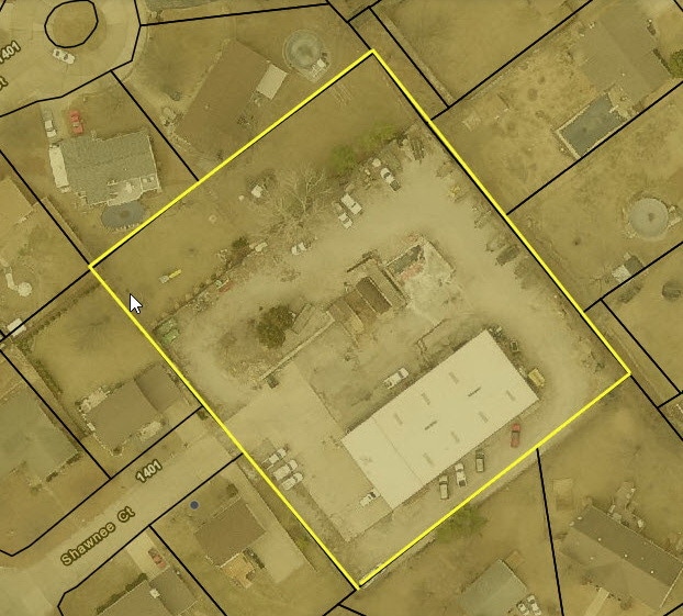
1400 Shawnee Ct, Arnold, MO 63010

Property Detail
1400 Shawnee Ct
01-4.0-19.0-4-009-031
US SURVEY 2991 PT LOT 27
Autorepair
Jefferson
CT1
Missouri
B and X Area of moderate flood hazard, usually the area between the limits of the 100-year and 500-year floods.
27
2024
1.23 AC
2025
Jefferson County
700118
St. Louis
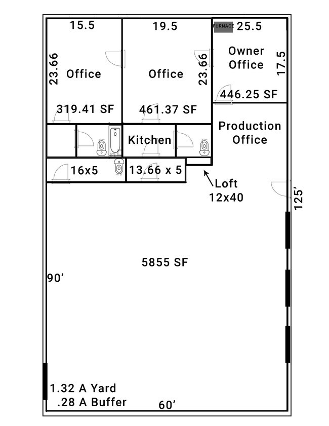
7,440 SF
St. Louis, MO-IL
NEARBY LISTINGS FOR SALE OR LEASE
-
-
-
No Photo
-
View all Arnold listings for sale on LoopNet.com
DEMOGRAPHICS near 1400 Shawnee Ct
1 mile
3 mile
5 mile
2025 Total Population
4,935
47,778
130,899
2030 Population
4,958
47,985
130,833
Pop Growth 2025-2030
+ 0.47%
+ 0.43%
(0.05%)
Average Age
43
43
43
2025 Total Households
2,110
19,299
52,492
HH Growth 2025-2030
+ 0.52%
+ 0.44%
(0.07%)
Median Household Inc
$73,913
$88,271
$91,097
Avg Household Size
2.30
2.40
2.50
2025 Avg HH Vehicles
2.00
2.00
2.00
Median Home Value
$210,760
$258,734
$286,704
Median Year Built
1973
1982
1983
Nearby Places
Map Layers
Map Styles
 Street
 Aerial
Transit
 Traffic
 Biking
Places
Listings with unknown addresses are not visible on the map
- Restaurants
- Banks
- Shops
- Fitness
- Groceries
PUBLIC TRANSPORTATION
AIRPORT
St Louis Lambert International
Drive
Walk
Distance
St Louis Lambert International
45 min
27.5 mi
Scott AFB/Midamerica St Louis
Drive
Walk
Distance
Scott AFB/Midamerica St Louis
62 min
43.6 mi
SALE & LEASE HISTORY
LISTING DATE
SALE/LEASE

Feb 04, 2020
For Sale
Aug 15, 2019
For Sale
Nearby Properties
Address
Land Use
TOTAL SIZE
Lot Size
Zoning
Address
Land Use
TOTAL SIZE
Lot Size
Zoning
76,892 SF
Address
Land Use
TOTAL SIZE
Lot Size
Zoning
53,714 SF
59.99 AC
FPNU
Address
Land Use
TOTAL SIZE
Lot Size
Zoning
221,771 SF
25.15 AC
CT1
Address
Land Use
TOTAL SIZE
Lot Size
Zoning
237,114 SF
18.12 AC
M1
Address
Land Use
TOTAL SIZE
Lot Size
Zoning
315,332 SF
53.99 AC
CT1
Address
Land Use
TOTAL SIZE
Lot Size
Zoning
205,040 SF
13.93 AC
M
Address
Land Use
TOTAL SIZE
Lot Size
Zoning
58,287 SF
18.90 AC
NU
Address
Land Use
TOTAL SIZE
Lot Size
Zoning
183,528 SF
20.63 AC
R6A
Address
Land Use
TOTAL SIZE
Lot Size
Zoning
150,857 SF
7.73 AC
R6A
Address
Land Use
TOTAL SIZE
Lot Size
Zoning
59,500 SF
17.78 AC
M
Address
Land Use
TOTAL SIZE
Lot Size
Zoning
170,620 SF
8.62 AC
CT1
Address
Land Use
TOTAL SIZE
Lot Size
Zoning
83,024 SF
10.99 AC
CT1
Address
Land Use
TOTAL SIZE
Lot Size
Zoning
110,282 SF
5.16 AC
R07
Address
Land Use
TOTAL SIZE
Lot Size
Zoning
143,779 SF
15.65 AC
R6A
Address
Land Use
TOTAL SIZE
Lot Size
Zoning
118,196 SF
13.33 AC
Address
Land Use
TOTAL SIZE
Lot Size
Zoning
138,591 SF
5.46 AC
Address
Land Use
TOTAL SIZE
Lot Size
Zoning
127,189 SF
10.76 AC
Address
Land Use
TOTAL SIZE
Lot Size
Zoning
52,886 SF
262.80 AC
P5
Address
Land Use
TOTAL SIZE
Lot Size
Zoning
67,462 SF
8.18 AC
CT1
Address
Land Use
TOTAL SIZE
Lot Size
Zoning
15.82 AC
NU
Address
Land Use
TOTAL SIZE
Lot Size
Zoning
184,685 SF
8.40 AC
Address
Land Use
TOTAL SIZE
Lot Size
Zoning
78,030 SF
10 AC
R6A
Address
Land Use
TOTAL SIZE
Lot Size
Zoning
221,956 SF
14.53 AC
CT1
Address
Land Use
TOTAL SIZE
Lot Size
Zoning
116,965 SF
13 AC
Address
Land Use
TOTAL SIZE
Lot Size
Zoning
95,382 SF
1.88 AC
CT1
Address
Land Use
TOTAL SIZE
Lot Size
Zoning
75,733 SF
2.46 AC
Address
Land Use
TOTAL SIZE
Lot Size
Zoning
62,170 SF
7.56 AC
FPM1
Address
Land Use
TOTAL SIZE
Lot Size
Zoning
94,833 SF
10.45 AC
R6A
Address
Land Use
TOTAL SIZE
Lot Size
Zoning
50,901 SF
3.14 AC
C-8
Address
Land Use
TOTAL SIZE
Lot Size
Zoning
71,112 SF
3.78 AC
R6A
The World's #1 Commercial Real Estate Marketplace
Connect with us
© 2026 CoStar Group
The information above has been obtained from sources believed reliable. While we do not doubt its accuracy we have not verified it and make no guarantee, warranty or representation about it. It is your responsibility to independently confirm its accuracy and completeness. Any projections, opinions, assumptions, or estimates used are for example only and do not represent the current or future performance of the property. The value of this transaction to you depends on tax and other factors which should be evaluated by your tax, financial, and legal advisors. You and your advisors should conduct a careful, independent investigation of the property to determine to your satisfaction the suitability of the property for your needs.