Property Record
Highway 231, Troy, AL 36081
NEARBY LISTINGS FOR SALE OR LEASE
Property Detail
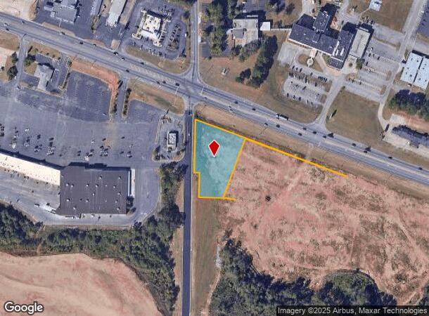
Highway 231
Troy, AL
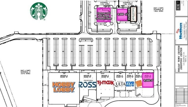
LOT # 1 FINAL PLAT OF TROJAN TOWNE PLAT NO2 PB 2020 PG 7 POB S4 T9N R21E
1702-0440040-030000
Pike
Vacantlandnec
Alabama
X
1
01109C0215C
10.37 AC
2025
Alabama South Area
2024
Other Market Areas
188900
DEMOGRAPHICS near Highway 231
1 Mile
3 Mile
5 Mile
2024 Total Population
2,755
12,754
19,964
2029 Population
2,717
12,713
19,880
Pop Growth 2024-2029
(1.38%)
(0.32%)
(0.42%)
Average Age
37
34
36
2024 Total Households
1,097
5,076
8,278
HH Growth 2024-2029
(1.28%)
(0.06%)
(0.22%)
Median Household Inc
$51,085
$32,543
$37,211
Avg Household Size
2.40
2.10
2.10
2024 Avg HH Vehicles
2.00
2.00
2.00
Median Home Value
$185,520
$167,824
$172,138
Median Year Built
1995
1990
1988
Nearby Places
- Restaurants
- Banks
- Shops
- Fitness
- Groceries
SALE & LEASE HISTORY
LISTING DATE
SALE/LEASE

Aug 06, 2019
For Lease
Apr 15, 2022
For Lease
Nearby Properties
Address
Land Use
TOTAL SIZE
Lot Size
Zoning
Address
Land Use
TOTAL SIZE
Lot Size
Zoning
14,100 SF
6.55 AC
C
Address
Land Use
TOTAL SIZE
Lot Size
Zoning
1,776 SF
9.72 AC
S
Address
Land Use
TOTAL SIZE
Lot Size
Zoning
7,551 SF
21 AC
S
Address
Land Use
TOTAL SIZE
Lot Size
Zoning
3,208 SF
12.97 AC
Address
Land Use
TOTAL SIZE
Lot Size
Zoning
2,960 SF
36.74 AC
C
Address
Land Use
TOTAL SIZE
Lot Size
Zoning
189,273 SF
21.24 AC
Address
Land Use
TOTAL SIZE
Lot Size
Zoning
23,200 SF
23.70 AC
I
Address
Land Use
TOTAL SIZE
Lot Size
Zoning
43,178 SF
12.71 AC
O
Address
Land Use
TOTAL SIZE
Lot Size
Zoning
81,925 SF
5.19 AC
C
Address
Land Use
TOTAL SIZE
Lot Size
Zoning
480 SF
20.50 AC
C
Address
Land Use
TOTAL SIZE
Lot Size
Zoning
14,082 SF
0.36 AC
S
Address
Land Use
TOTAL SIZE
Lot Size
Zoning
111,427 SF
14.90 AC
Address
Land Use
TOTAL SIZE
Lot Size
Zoning
2,932 SF
6.50 AC
M
Address
Land Use
TOTAL SIZE
Lot Size
Zoning
168,000 SF
8.93 AC
C
Address
Land Use
TOTAL SIZE
Lot Size
Zoning
99,332 SF
11.06 AC
C
Address
Land Use
TOTAL SIZE
Lot Size
Zoning
70.29 AC
Address
Land Use
TOTAL SIZE
Lot Size
Zoning
68,466 SF
3.03 AC
C
Address
Land Use
TOTAL SIZE
Lot Size
Zoning
5,363 SF
44.95 AC
Address
Land Use
TOTAL SIZE
Lot Size
Zoning
4.29 AC
N
Address
Land Use
TOTAL SIZE
Lot Size
Zoning
11,139 SF
2.50 AC
S
Address
Land Use
TOTAL SIZE
Lot Size
Zoning
6,000 SF
55 AC
I
Address
Land Use
TOTAL SIZE
Lot Size
Zoning
14,395 SF
2.18 AC
Address
Land Use
TOTAL SIZE
Lot Size
Zoning
20,590 SF
14.80 AC
C
Address
Land Use
TOTAL SIZE
Lot Size
Zoning
10,633 SF
2.79 AC
C
Address
Land Use
TOTAL SIZE
Lot Size
Zoning
15,320 SF
1.88 AC
S
Address
Land Use
TOTAL SIZE
Lot Size
Zoning
6,888 SF
0.98 AC
S
Address
Land Use
TOTAL SIZE
Lot Size
Zoning
66,591 SF
8.78 AC
C
Address
Land Use
TOTAL SIZE
Lot Size
Zoning
17,268 SF
3.96 AC
The World's #1 Commercial Real Estate Marketplace
Connect with us
© 2025 CoStar Group
The information above has been obtained from sources believed reliable. While we do not doubt its accuracy we have not verified it and make no guarantee, warranty or representation about it. It is your responsibility to independently confirm its accuracy and completeness. Any projections, opinions, assumptions, or estimates used are for example only and do not represent the current or future performance of the property. The value of this transaction to you depends on tax and other factors which should be evaluated by your tax, financial, and legal advisors. You and your advisors should conduct a careful, independent investigation of the property to determine to your satisfaction the suitability of the property for your needs.