Property Record
1400 N Us Highway 441, Lady Lake, FL 32159

Current Lease Availabilities
NEARBY LISTINGS FOR SALE OR LEASE
Property Detail
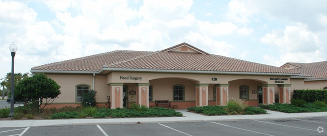
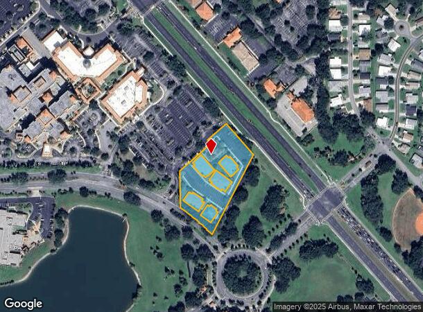
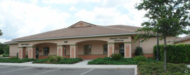
1400 N Us Highway 441
D01J1200
Spanish Plaines 12
Officebuilding
TRACT 12 SPANISH PLAINES LESS:PORT OF TR 12 SPANISH PLAINES PB 5 PGS 21-21D DESC AS: COMM AT MOST N/LY COR OFTRACT 12 S 25 DEG 5637W 383.25 FT TO POB S 55 DEG 3409E 59.75 FT S 34 DEG 2551W 9.58 FT S 55 DEG 3409E16.46 FT S 34 DEG *** CONTINUED ON TAX
X
Sumter
12119C0079D
Florida
2025
1.87 AC
2025
Ocala
910800
Other Market Areas
4,128 SF
The Villages, FL
DEMOGRAPHICS near 1400 N Us Highway 441
1 Mile
3 Mile
5 Mile
2024 Total Population
6,814
41,857
96,357
2029 Population
8,297
50,389
117,076
Pop Growth 2024-2029
+ 21.76%
+ 20.38%
+ 21.50%
Average Age
72
68
65
2024 Total Households
4,025
23,805
52,162
HH Growth 2024-2029
+ 21.57%
+ 20.66%
+ 22.09%
Median Household Inc
$58,532
$55,061
$61,588
Avg Household Size
1.70
1.70
1.80
2024 Avg HH Vehicles
1.00
1.00
1.00
Median Home Value
$262,490
$246,053
$270,994
Median Year Built
1994
1996
2002
Nearby Places
- Restaurants
- Banks
- Shops
- Fitness
- Groceries
Nearby Properties
Address
Land Use
TOTAL SIZE
Lot Size
Zoning
Address
Land Use
TOTAL SIZE
Lot Size
Zoning
395,767 SF
33.07 AC
Address
Land Use
TOTAL SIZE
Lot Size
Zoning
404,584 SF
29.32 AC
MF12
Address
Land Use
TOTAL SIZE
Lot Size
Zoning
344,318 SF
25.73 AC
MF18
Address
Land Use
TOTAL SIZE
Lot Size
Zoning
344,823 SF
17.53 AC
Address
Land Use
TOTAL SIZE
Lot Size
Zoning
122,427 SF
11.40 AC
PUD
Address
Land Use
TOTAL SIZE
Lot Size
Zoning
58,955 SF
6.85 AC
Address
Land Use
TOTAL SIZE
Lot Size
Zoning
171,544 SF
15.78 AC
CP
Address
Land Use
TOTAL SIZE
Lot Size
Zoning
71,467 SF
9.31 AC
Address
Land Use
TOTAL SIZE
Lot Size
Zoning
30,641 SF
103.82 AC
CT
Address
Land Use
TOTAL SIZE
Lot Size
Zoning
165,197 SF
16.74 AC
HC
Address
Land Use
TOTAL SIZE
Lot Size
Zoning
28,844 SF
12.90 AC
Address
Land Use
TOTAL SIZE
Lot Size
Zoning
60,998 SF
5 AC
Address
Land Use
TOTAL SIZE
Lot Size
Zoning
94,208 SF
12.72 AC
CP
Address
Land Use
TOTAL SIZE
Lot Size
Zoning
90,064 SF
8.12 AC
A
Address
Land Use
TOTAL SIZE
Lot Size
Zoning
101,064 SF
7.64 AC
CP
Address
Land Use
TOTAL SIZE
Lot Size
Zoning
191,879 SF
26.11 AC
PUD
Address
Land Use
TOTAL SIZE
Lot Size
Zoning
77,922 SF
7.31 AC
Address
Land Use
TOTAL SIZE
Lot Size
Zoning
78,586 SF
1.61 AC
CP
Address
Land Use
TOTAL SIZE
Lot Size
Zoning
29,018 SF
2.43 AC
HC
Address
Land Use
TOTAL SIZE
Lot Size
Zoning
45,553 SF
12.86 AC
Address
Land Use
TOTAL SIZE
Lot Size
Zoning
91,762 SF
3.24 AC
Address
Land Use
TOTAL SIZE
Lot Size
Zoning
69,101 SF
9.69 AC
CP
Address
Land Use
TOTAL SIZE
Lot Size
Zoning
169,950 SF
18.74 AC
A
Address
Land Use
TOTAL SIZE
Lot Size
Zoning
101,154 SF
19.35 AC
PFD
Address
Land Use
TOTAL SIZE
Lot Size
Zoning
103,632 SF
9.59 AC
Address
Land Use
TOTAL SIZE
Lot Size
Zoning
106,910 SF
10.40 AC
CP
Address
Land Use
TOTAL SIZE
Lot Size
Zoning
43,686 SF
1.23 AC
CP
Address
Land Use
TOTAL SIZE
Lot Size
Zoning
67,350 SF
1.52 AC
CP
Address
Land Use
TOTAL SIZE
Lot Size
Zoning
12,456 SF
88.51 AC
C1
Address
Land Use
TOTAL SIZE
Lot Size
Zoning
73,894 SF
2.34 AC
CP
The World's #1 Commercial Real Estate Marketplace
Connect with us
© 2025 CoStar Group
The information above has been obtained from sources believed reliable. While we do not doubt its accuracy we have not verified it and make no guarantee, warranty or representation about it. It is your responsibility to independently confirm its accuracy and completeness. Any projections, opinions, assumptions, or estimates used are for example only and do not represent the current or future performance of the property. The value of this transaction to you depends on tax and other factors which should be evaluated by your tax, financial, and legal advisors. You and your advisors should conduct a careful, independent investigation of the property to determine to your satisfaction the suitability of the property for your needs.