Property Record
1400 Us Route 1, Cape Neddick, ME 03902


NEARBY LISTINGS FOR SALE OR LEASE
-
-
View all Cape Neddick listings for sale on LoopNet.com
Property Detail
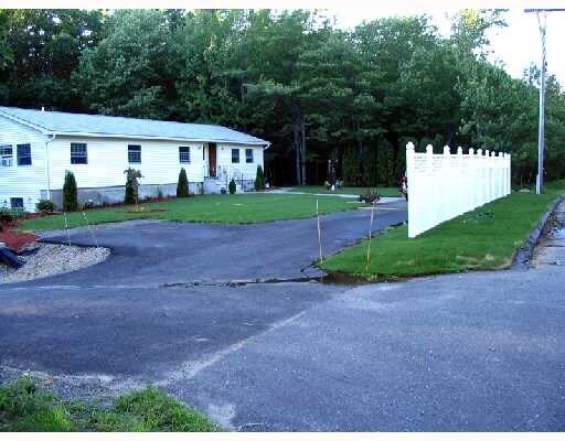
1400 Us Route 1
Commercialnec
York
X
Maine
23031C0678G
5.74 AC
2024
York County
2024
Portland/South Portland
036002
Portland-South Portland, ME
7,700 SF
YORK-000097-000000-000020
DEMOGRAPHICS near 1400 Us Route 1
1 Mile
3 Mile
5 Mile
2024 Total Population
558
6,093
12,435
2029 Population
589
6,426
13,021
Pop Growth 2024-2029
+ 5.56%
+ 5.47%
+ 4.71%
Average Age
47
49
49
2024 Total Households
246
2,680
5,517
HH Growth 2024-2029
+ 5.28%
+ 5.30%
+ 4.50%
Median Household Inc
$93,055
$102,924
$95,893
Avg Household Size
2.30
2.30
2.20
2024 Avg HH Vehicles
2.00
2.00
2.00
Median Home Value
$630,531
$526,087
$514,949
Median Year Built
1971
1972
1976
Nearby Places
Map Layers
Map Styles
 Street
 Aerial
- Restaurants
- Banks
- Shops
- Fitness
- Groceries
PUBLIC TRANSPORTATION
COMMUTER RAIL
Wells (Downeaster - Amtrak)
DRIVE
WALK
Distance
Wells (Downeaster - Amtrak)
21 min
10.0 mi
AIRPORT
Portsmouth International at Pease
DRIVE
WALK
Distance
Portsmouth International at Pease
24 min
14.8 mi
Freight Ports
Portland, ME
DRIVE
WALK
Distance
Portland, ME
56 min
40.7 mi
Nearby Properties
Address
Land Use
TOTAL SIZE
Lot Size
Zoning
Address
Land Use
TOTAL SIZE
Lot Size
Zoning
64.25 AC
R2
Address
Land Use
TOTAL SIZE
Lot Size
Zoning
5.82 AC
R7
Address
Land Use
TOTAL SIZE
Lot Size
Zoning
4,271 SF
4.10 AC
R2
Address
Land Use
TOTAL SIZE
Lot Size
Zoning
13.33 AC
R1-6
Address
Land Use
TOTAL SIZE
Lot Size
Zoning
2,232 SF
58.62 AC
RT1
Address
Land Use
TOTAL SIZE
Lot Size
Zoning
2.38 AC
SGD-2
Address
Land Use
TOTAL SIZE
Lot Size
Zoning
6,378 SF
2.46 AC
R2
Address
Land Use
TOTAL SIZE
Lot Size
Zoning
400 SF
0.36 AC
GB02
Address
Land Use
TOTAL SIZE
Lot Size
Zoning
2,400 SF
29.13 AC
G2
Address
Land Use
TOTAL SIZE
Lot Size
Zoning
4,718 SF
2.38 AC
SLR
Address
Land Use
TOTAL SIZE
Lot Size
Zoning
1.69 AC
R5
Address
Land Use
TOTAL SIZE
Lot Size
Zoning
1.83 AC
R2
Address
Land Use
TOTAL SIZE
Lot Size
Zoning
9,214 SF
2.15 AC
R5
Address
Land Use
TOTAL SIZE
Lot Size
Zoning
25,061 SF
0.40 AC
B3
Address
Land Use
TOTAL SIZE
Lot Size
Zoning
1.02 AC
R5
Address
Land Use
TOTAL SIZE
Lot Size
Zoning
924 SF
2.80 AC
R5
Address
Land Use
TOTAL SIZE
Lot Size
Zoning
0.73 AC
R5
Address
Land Use
TOTAL SIZE
Lot Size
Zoning
7,728 SF
3 AC
SLC
Address
Land Use
TOTAL SIZE
Lot Size
Zoning
20,229 SF
0.64 AC
LBD
Address
Land Use
TOTAL SIZE
Lot Size
Zoning
1.30 AC
R2
Address
Land Use
TOTAL SIZE
Lot Size
Zoning
19,126 SF
0.24 AC
B3
Address
Land Use
TOTAL SIZE
Lot Size
Zoning
8.88 AC
R6
Address
Land Use
TOTAL SIZE
Lot Size
Zoning
1.88 AC
R2
Address
Land Use
TOTAL SIZE
Lot Size
Zoning
19,215 SF
0.86 AC
R7
Address
Land Use
TOTAL SIZE
Lot Size
Zoning
4,167 SF
1.27 AC
R4
Address
Land Use
TOTAL SIZE
Lot Size
Zoning
16,968 SF
0.56 AC
B3
Address
Land Use
TOTAL SIZE
Lot Size
Zoning
2.56 AC
R6
Address
Land Use
TOTAL SIZE
Lot Size
Zoning
249.19 AC
R2
Address
Land Use
TOTAL SIZE
Lot Size
Zoning
8,916 SF
0.28 AC
SGD-2
Address
Land Use
TOTAL SIZE
Lot Size
Zoning
1 AC
WPD
The World's #1 Commercial Real Estate Marketplace
Connect with us
© 2025 CoStar Group
The information above has been obtained from sources believed reliable. While we do not doubt its accuracy we have not verified it and make no guarantee, warranty or representation about it. It is your responsibility to independently confirm its accuracy and completeness. Any projections, opinions, assumptions, or estimates used are for example only and do not represent the current or future performance of the property. The value of this transaction to you depends on tax and other factors which should be evaluated by your tax, financial, and legal advisors. You and your advisors should conduct a careful, independent investigation of the property to determine to your satisfaction the suitability of the property for your needs.