Property Record
1401 Bellwood Rd, North Chesterfield, VA 23237


NEARBY LISTINGS FOR SALE OR LEASE
Property Detail
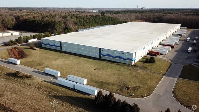
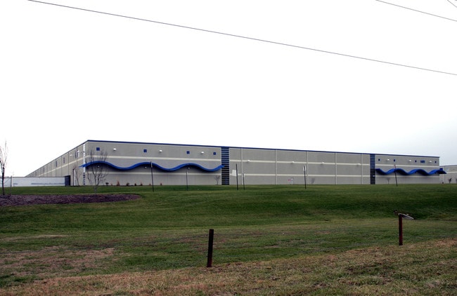
1401 Bellwood Rd
798-67-65-80-600-000
S/L Of Bellwood Rd Parcel A
Distributionwarehouseregional
S/L OF BELLWOOD RD PARCEL A
X
Chesterfield
5101290100E
Virginia
0
33.22 AC
2025
Jeff Davis Corridor
100403
Richmond VA
406,490 SF
Richmond, VA
DEMOGRAPHICS near 1401 Bellwood Rd
1 Mile
3 Mile
5 Mile
2024 Total Population
261
21,045
81,000
2029 Population
282
23,082
87,710
Pop Growth 2024-2029
+ 8.05%
+ 9.68%
+ 8.28%
Average Age
35
38
39
2024 Total Households
105
7,993
30,350
HH Growth 2024-2029
+ 8.57%
+ 9.72%
+ 8.38%
Median Household Inc
$62,250
$52,589
$63,197
Avg Household Size
2.40
2.60
2.60
2024 Avg HH Vehicles
2.00
2.00
2.00
Median Home Value
$71,999
$238,037
$249,232
Median Year Built
1993
1981
1983
Nearby Places
Map Layers
Map Styles
 Street
 Aerial
- Restaurants
- Banks
- Shops
- Fitness
- Groceries
PUBLIC TRANSPORTATION
AIRPORT
Richmond International
DRIVE
WALK
Distance
Richmond International
25 min
15.3 mi
Freight Ports
Virginia Port Authority - Richmond
DRIVE
WALK
Distance
Virginia Port Authority - Richmond
15 min
8.5 mi
Nearby Properties
Address
Land Use
TOTAL SIZE
Lot Size
Zoning
Address
Land Use
TOTAL SIZE
Lot Size
Zoning
100 SF
652.52 AC
A - AGRICU
Address
Land Use
TOTAL SIZE
Lot Size
Zoning
231,168 SF
57.31 AC
R7 - SINGL
Address
Land Use
TOTAL SIZE
Lot Size
Zoning
413.51 AC
I3 - HVY I
Address
Land Use
TOTAL SIZE
Lot Size
Zoning
437,024 SF
39.40 AC
I3 - HVY I
Address
Land Use
TOTAL SIZE
Lot Size
Zoning
406,110 SF
57.69 AC
I3 - HVY I
Address
Land Use
TOTAL SIZE
Lot Size
Zoning
320,853 SF
33.68 AC
I3 - HVY I
Address
Land Use
TOTAL SIZE
Lot Size
Zoning
220,825 SF
55.17 AC
I3 - HVY I
Address
Land Use
TOTAL SIZE
Lot Size
Zoning
55,952 SF
11.82 AC
C3 - COMMU
Address
Land Use
TOTAL SIZE
Lot Size
Zoning
406,490 SF
19.58 AC
I3 - HVY I
Address
Land Use
TOTAL SIZE
Lot Size
Zoning
67,060 SF
4.93 AC
C5 - GEN B
Address
Land Use
TOTAL SIZE
Lot Size
Zoning
23,586 SF
41.23 AC
I2 - GEN I
Address
Land Use
TOTAL SIZE
Lot Size
Zoning
100 SF
15.43 AC
RMF - RES,
Address
Land Use
TOTAL SIZE
Lot Size
Zoning
103,863 SF
20.55 AC
R7 - SINGL
Address
Land Use
TOTAL SIZE
Lot Size
Zoning
86,564 SF
22.62 AC
M-2 HEAVY
Address
Land Use
TOTAL SIZE
Lot Size
Zoning
318,611 SF
24.17 AC
I3 - HVY I
Address
Land Use
TOTAL SIZE
Lot Size
Zoning
115,080 SF
124 AC
M-2 HEAVY
Address
Land Use
TOTAL SIZE
Lot Size
Zoning
138,860 SF
23.68 AC
RMF - RES,
Address
Land Use
TOTAL SIZE
Lot Size
Zoning
324,530 SF
31.47 AC
I3 - HVY I
Address
Land Use
TOTAL SIZE
Lot Size
Zoning
100 SF
17.10 AC
RMF - RES,
Address
Land Use
TOTAL SIZE
Lot Size
Zoning
161,915 SF
21.43 AC
I3 - HVY I
Address
Land Use
TOTAL SIZE
Lot Size
Zoning
133,039 SF
10.40 AC
I3 - HVY I
Address
Land Use
TOTAL SIZE
Lot Size
Zoning
159,722 SF
85.50 AC
I3 - HVY I
Address
Land Use
TOTAL SIZE
Lot Size
Zoning
86,519 SF
11.51 AC
R7 - SINGL
Address
Land Use
TOTAL SIZE
Lot Size
Zoning
506 SF
42.94 AC
I3 - HVY I
Address
Land Use
TOTAL SIZE
Lot Size
Zoning
287 SF
57.15 AC
I3 - HVY I
Address
Land Use
TOTAL SIZE
Lot Size
Zoning
5,775 SF
59.60 AC
I3 - HVY I
Address
Land Use
TOTAL SIZE
Lot Size
Zoning
240 SF
28.09 AC
I3 - HVY I
Address
Land Use
TOTAL SIZE
Lot Size
Zoning
74,575 SF
15.49 AC
I1 - LT IN
Address
Land Use
TOTAL SIZE
Lot Size
Zoning
45,124 SF
44.79 AC
I3 - HVY I
The World's #1 Commercial Real Estate Marketplace
Connect with us
© 2025 CoStar Group
The information above has been obtained from sources believed reliable. While we do not doubt its accuracy we have not verified it and make no guarantee, warranty or representation about it. It is your responsibility to independently confirm its accuracy and completeness. Any projections, opinions, assumptions, or estimates used are for example only and do not represent the current or future performance of the property. The value of this transaction to you depends on tax and other factors which should be evaluated by your tax, financial, and legal advisors. You and your advisors should conduct a careful, independent investigation of the property to determine to your satisfaction the suitability of the property for your needs.