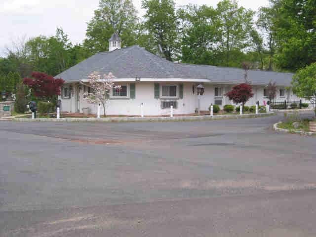
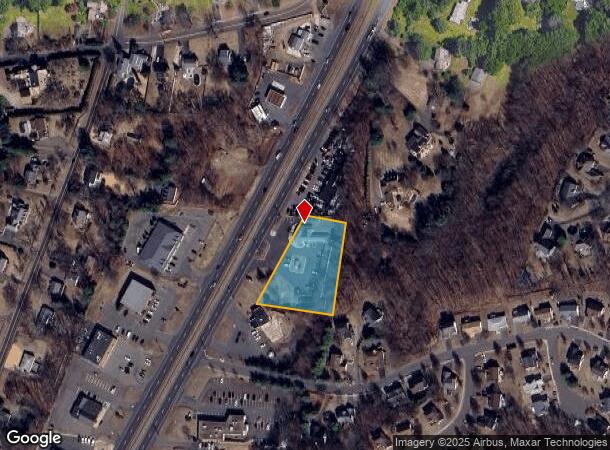
Property Record
1401 Berlin Tpke, Berlin, CT 06037
NEARBY LISTINGS FOR SALE OR LEASE
Property Detail
1401 Berlin Tpke
BERL-000163-000142-000053
Hartford
Motel
Connecticut
X
53
09003C0626F
1.17 AC
2025
Berlin Outlying
2025
Hartford
400200
Hartford-West Hartford-East Hartford, CT
6,050 SF
DEMOGRAPHICS near 1401 Berlin Tpke
1 Mile
3 Mile
5 Mile
2024 Total Population
3,736
30,484
123,850
2029 Population
3,693
30,276
122,970
Pop Growth 2024-2029
(1.15%)
(0.68%)
(0.71%)
Average Age
45
43
41
2024 Total Households
1,513
13,356
51,173
HH Growth 2024-2029
(1.19%)
(0.72%)
(0.74%)
Median Household Inc
$101,578
$93,717
$75,644
Avg Household Size
2.50
2.20
2.30
2024 Avg HH Vehicles
2.00
2.00
2.00
Median Home Value
$320,254
$286,604
$264,988
Median Year Built
1974
1979
1970
Nearby Places
Map Layers
Map Styles
 Street
 Aerial
- Restaurants
- Banks
- Shops
- Fitness
- Groceries
PUBLIC TRANSPORTATION
COMMUTER RAIL
Berlin (Hartford Line - CONN DOT)
DRIVE
WALK
Distance
Berlin (Hartford Line - CONN DOT)
5 min
2.2 mi
Berlin Amtrak (Amtrak Hartford Line - Amtrak, Hartford Line - Amtrak, Northeast Regional - Amtrak, Valley Flyer - Amtrak)
DRIVE
WALK
Distance
Berlin Amtrak (Amtrak Hartford Line - Amtrak, Hartford Line - Amtrak, Northeast Regional - Amtrak, Valley Flyer - Amtrak)
5 min
2.2 mi
AIRPORT
Tweed/New Haven
DRIVE
WALK
Distance
Tweed/New Haven
40 min
28.9 mi
Bradley International
DRIVE
WALK
Distance
Bradley International
47 min
29.2 mi
Freight Ports
Port of New Haven
DRIVE
WALK
Distance
Port of New Haven
36 min
26.6 mi
Nearby Properties
Address
Land Use
TOTAL SIZE
Lot Size
Zoning
Address
Land Use
TOTAL SIZE
Lot Size
Zoning
109,079 SF
110.62 AC
OT
Address
Land Use
TOTAL SIZE
Lot Size
Zoning
17.38 AC
PRD
Address
Land Use
TOTAL SIZE
Lot Size
Zoning
29.45 AC
R-15
Address
Land Use
TOTAL SIZE
Lot Size
Zoning
241,225 SF
25.64 AC
R-11
Address
Land Use
TOTAL SIZE
Lot Size
Zoning
15.10 AC
PRD
Address
Land Use
TOTAL SIZE
Lot Size
Zoning
19.49 AC
PRD
Address
Land Use
TOTAL SIZE
Lot Size
Zoning
11.81 AC
PRD
Address
Land Use
TOTAL SIZE
Lot Size
Zoning
27,152 SF
8.75 AC
R-25
Address
Land Use
TOTAL SIZE
Lot Size
Zoning
21.35 AC
PD
Address
Land Use
TOTAL SIZE
Lot Size
Zoning
129,626 SF
22.36 AC
IT
Address
Land Use
TOTAL SIZE
Lot Size
Zoning
13.28 AC
PRD
Address
Land Use
TOTAL SIZE
Lot Size
Zoning
5.20 AC
PD
Address
Land Use
TOTAL SIZE
Lot Size
Zoning
38,860 SF
38.47 AC
PS-B
Address
Land Use
TOTAL SIZE
Lot Size
Zoning
185,902 SF
101.89 AC
GI-2
Address
Land Use
TOTAL SIZE
Lot Size
Zoning
41.78 AC
IT
Address
Land Use
TOTAL SIZE
Lot Size
Zoning
76,510 SF
10 AC
R-11
Address
Land Use
TOTAL SIZE
Lot Size
Zoning
15.50 AC
PRD
Address
Land Use
TOTAL SIZE
Lot Size
Zoning
18.53 AC
BTD
Address
Land Use
TOTAL SIZE
Lot Size
Zoning
91,663 SF
22.20 AC
R-21
Address
Land Use
TOTAL SIZE
Lot Size
Zoning
197,680 SF
26.91 AC
IT
Address
Land Use
TOTAL SIZE
Lot Size
Zoning
25.10 AC
R-15
Address
Land Use
TOTAL SIZE
Lot Size
Zoning
5.65 AC
HB
Address
Land Use
TOTAL SIZE
Lot Size
Zoning
133,290 SF
11.64 AC
PD
Address
Land Use
TOTAL SIZE
Lot Size
Zoning
13.02 AC
HB
Address
Land Use
TOTAL SIZE
Lot Size
Zoning
67,050 SF
20.36 AC
R-15
Address
Land Use
TOTAL SIZE
Lot Size
Zoning
61,435 SF
25.96 AC
R-15
Address
Land Use
TOTAL SIZE
Lot Size
Zoning
6.09 AC
PRD
Address
Land Use
TOTAL SIZE
Lot Size
Zoning
72,920 SF
4.10 AC
HB
Address
Land Use
TOTAL SIZE
Lot Size
Zoning
122,735 SF
16.85 AC
HB
Address
Land Use
TOTAL SIZE
Lot Size
Zoning
4,674 SF
11.48 AC
WHD
The World's #1 Commercial Real Estate Marketplace
Connect with us
© 2026 CoStar Group
The information above has been obtained from sources believed reliable. While we do not doubt its accuracy we have not verified it and make no guarantee, warranty or representation about it. It is your responsibility to independently confirm its accuracy and completeness. Any projections, opinions, assumptions, or estimates used are for example only and do not represent the current or future performance of the property. The value of this transaction to you depends on tax and other factors which should be evaluated by your tax, financial, and legal advisors. You and your advisors should conduct a careful, independent investigation of the property to determine to your satisfaction the suitability of the property for your needs.