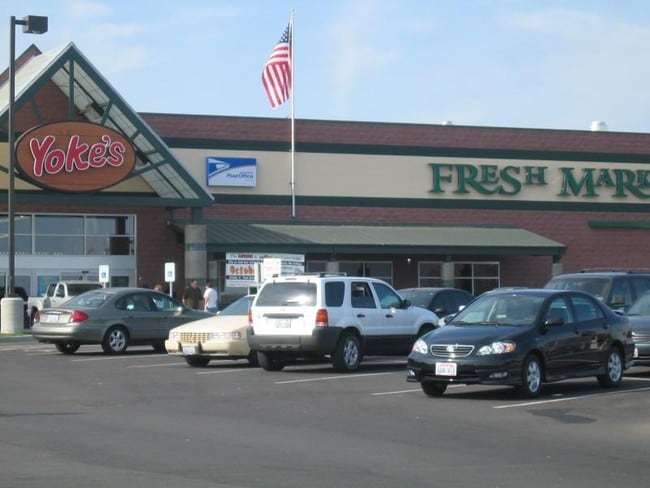
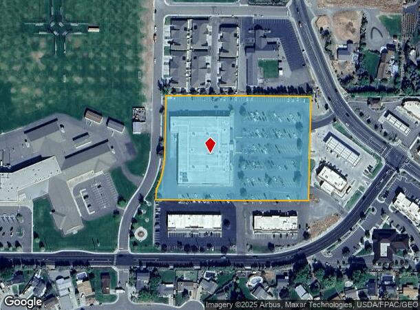
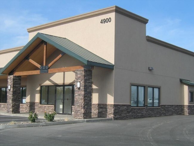
Property Record
1401 Bombing Range Rd, West Richland, WA 99353
NEARBY LISTINGS FOR SALE OR LEASE
Property Detail
1401 Bombing Range Rd
Other Market Areas
Willamette Heights
Kennewick-Richland, WA
SECTION 6 TOWNSHIP 9 RANGE 28 QUARTER SE; LOT 217, WILLAMETTE HEIGHTS, ACCORDING TO THE PLAT THEREOF RECORDED IN VOLUME 5 OF PLATS, PAGE 52, RECORDS OF BENTON COUNTY, WASHINGTON; TOGETHER WITH THE WEST 280.02 FEET OF LOT 216 AND TOGETHER WITH THE
106984020217001
Benton
Supermarket
Washington
2024
217
2024
5.39 AC
010708
Yakima/Kennewick
59,102 SF
DEMOGRAPHICS near 1401 Bombing Range Rd
1 Mile
3 Mile
5 Mile
2024 Total Population
8,890
33,552
68,069
2029 Population
9,596
36,101
73,222
Pop Growth 2024-2029
+ 7.94%
+ 7.60%
+ 7.57%
Average Age
38
38
39
2024 Total Households
3,102
12,271
25,935
HH Growth 2024-2029
+ 7.99%
+ 7.60%
+ 7.55%
Median Household Inc
$115,319
$107,860
$96,357
Avg Household Size
2.80
2.70
2.60
2024 Avg HH Vehicles
3.00
2.00
2.00
Median Home Value
$371,955
$364,178
$371,102
Median Year Built
2000
1995
1989
Nearby Places
Map Layers
Map Styles
 Street
 Aerial
- Restaurants
- Banks
- Shops
- Fitness
- Groceries
PUBLIC TRANSPORTATION
AIRPORT
Tri-Cities
DRIVE
WALK
Distance
Tri-Cities
26 min
15.4 mi
Nearby Properties
Address
Land Use
TOTAL SIZE
Lot Size
Zoning
Address
Land Use
TOTAL SIZE
Lot Size
Zoning
143,592 SF
6.86 AC
RICHLAND -
Address
Land Use
TOTAL SIZE
Lot Size
Zoning
236,556 SF
11.34 AC
Address
Land Use
TOTAL SIZE
Lot Size
Zoning
185,302 SF
9.13 AC
Address
Land Use
TOTAL SIZE
Lot Size
Zoning
118,956 SF
30.48 AC
Address
Land Use
TOTAL SIZE
Lot Size
Zoning
216,270 SF
22.32 AC
Address
Land Use
TOTAL SIZE
Lot Size
Zoning
113,052 SF
3.32 AC
Address
Land Use
TOTAL SIZE
Lot Size
Zoning
109,517 SF
4.67 AC
Address
Land Use
TOTAL SIZE
Lot Size
Zoning
76,389 SF
14.43 AC
Address
Land Use
TOTAL SIZE
Lot Size
Zoning
102,146 SF
40 AC
Address
Land Use
TOTAL SIZE
Lot Size
Zoning
126,251 SF
7 AC
Address
Land Use
TOTAL SIZE
Lot Size
Zoning
76,249 SF
13 AC
Address
Land Use
TOTAL SIZE
Lot Size
Zoning
81,928 SF
4.49 AC
Address
Land Use
TOTAL SIZE
Lot Size
Zoning
208,285 SF
5.24 AC
Address
Land Use
TOTAL SIZE
Lot Size
Zoning
74,920 SF
4.57 AC
Address
Land Use
TOTAL SIZE
Lot Size
Zoning
42,782 SF
72.06 AC
Address
Land Use
TOTAL SIZE
Lot Size
Zoning
127,195 SF
9.16 AC
Address
Land Use
TOTAL SIZE
Lot Size
Zoning
74,352 SF
13.55 AC
RICHLAND -
Address
Land Use
TOTAL SIZE
Lot Size
Zoning
123,936 SF
5.66 AC
Address
Land Use
TOTAL SIZE
Lot Size
Zoning
79,887 SF
21.87 AC
Address
Land Use
TOTAL SIZE
Lot Size
Zoning
62,733 SF
14.60 AC
Address
Land Use
TOTAL SIZE
Lot Size
Zoning
74,028 SF
6.02 AC
Address
Land Use
TOTAL SIZE
Lot Size
Zoning
35,488 SF
4.99 AC
Address
Land Use
TOTAL SIZE
Lot Size
Zoning
102,189 SF
12.57 AC
Address
Land Use
TOTAL SIZE
Lot Size
Zoning
56,700 SF
6.47 AC
Address
Land Use
TOTAL SIZE
Lot Size
Zoning
71,700 SF
9.33 AC
Address
Land Use
TOTAL SIZE
Lot Size
Zoning
39,096 SF
2.18 AC
Address
Land Use
TOTAL SIZE
Lot Size
Zoning
28,865 SF
8.42 AC
Address
Land Use
TOTAL SIZE
Lot Size
Zoning
11,625 SF
29.71 AC
Address
Land Use
TOTAL SIZE
Lot Size
Zoning
54,283 SF
12 AC
The World's #1 Commercial Real Estate Marketplace
Connect with us
© 2026 CoStar Group
The information above has been obtained from sources believed reliable. While we do not doubt its accuracy we have not verified it and make no guarantee, warranty or representation about it. It is your responsibility to independently confirm its accuracy and completeness. Any projections, opinions, assumptions, or estimates used are for example only and do not represent the current or future performance of the property. The value of this transaction to you depends on tax and other factors which should be evaluated by your tax, financial, and legal advisors. You and your advisors should conduct a careful, independent investigation of the property to determine to your satisfaction the suitability of the property for your needs.