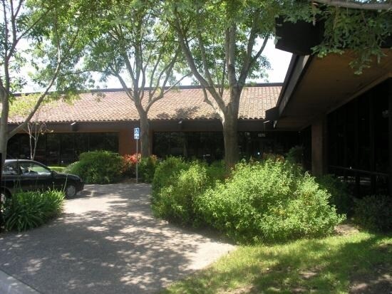
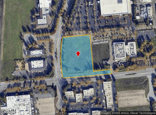
Property Record
0 Northpoint Pkwy, Santa Rosa, CA
NEARBY LISTINGS FOR SALE OR LEASE
Property Detail
0 Northpoint Pkwy
010-450-006
2002 FM PTN 035-132-001& 035-530-001&046
Industrialacreage
Sonoma
X
California
06097C0717G
4.41 AC
2024
Santa Rosa
2025
North Bay/Santa Rosa
153200
Santa Rosa, CA
DEMOGRAPHICS near 0 Northpoint Pkwy
1 Mile
3 Mile
5 Mile
2024 Total Population
13,133
91,955
183,651
2029 Population
12,896
90,688
181,473
Pop Growth 2024-2029
(1.80%)
(1.38%)
(1.19%)
Average Age
38
38
40
2024 Total Households
3,921
30,745
66,880
HH Growth 2024-2029
(1.86%)
(1.43%)
(1.19%)
Median Household Inc
$92,792
$80,550
$88,740
Avg Household Size
3.20
2.80
2.60
2024 Avg HH Vehicles
2.00
2.00
2.00
Median Home Value
$666,027
$634,563
$706,625
Median Year Built
1997
1981
1978
Nearby Places
- Restaurants
- Banks
- Shops
- Fitness
- Groceries
PUBLIC TRANSPORTATION
COMMUTER RAIL
Santa Rosa Downtown Smart (Main Line - Sonoma Marin Area Rail Transit)
DRIVE
WALK
Distance
Santa Rosa Downtown Smart (Main Line - Sonoma Marin Area Rail Transit)
7 min
3.2 mi
Santa Rosa North Smart (Main Line - Sonoma Marin Area Rail Transit)
DRIVE
WALK
Distance
Santa Rosa North Smart (Main Line - Sonoma Marin Area Rail Transit)
9 min
4.4 mi
AIRPORT
Charles M Schulz - Sonoma County
DRIVE
WALK
Distance
Charles M Schulz - Sonoma County
18 min
11.2 mi
Freight Ports
Port of Richmond
DRIVE
WALK
Distance
Port of Richmond
65 min
49.0 mi
Nearby Properties
Address
Land Use
TOTAL SIZE
Lot Size
Zoning
Address
Land Use
TOTAL SIZE
Lot Size
Zoning
285,160 SF
8.23 AC
Address
Land Use
TOTAL SIZE
Lot Size
Zoning
249,210 SF
22.98 AC
C-2
Address
Land Use
TOTAL SIZE
Lot Size
Zoning
441,698 SF
10.23 AC
C2
Address
Land Use
TOTAL SIZE
Lot Size
Zoning
222,278 SF
13.39 AC
CITYSR
Address
Land Use
TOTAL SIZE
Lot Size
Zoning
203,119 SF
9.35 AC
Address
Land Use
TOTAL SIZE
Lot Size
Zoning
167,485 SF
7.81 AC
Address
Land Use
TOTAL SIZE
Lot Size
Zoning
74,000 SF
0.51 AC
Address
Land Use
TOTAL SIZE
Lot Size
Zoning
8.06 AC
Address
Land Use
TOTAL SIZE
Lot Size
Zoning
142,297 SF
4.65 AC
Address
Land Use
TOTAL SIZE
Lot Size
Zoning
105,696 SF
5.46 AC
Address
Land Use
TOTAL SIZE
Lot Size
Zoning
87,300 SF
6.64 AC
Address
Land Use
TOTAL SIZE
Lot Size
Zoning
71,800 SF
7.76 AC
CIPD
Address
Land Use
TOTAL SIZE
Lot Size
Zoning
87,750 SF
5.43 AC
Address
Land Use
TOTAL SIZE
Lot Size
Zoning
82,215 SF
7.91 AC
C2
Address
Land Use
TOTAL SIZE
Lot Size
Zoning
7,370 SF
4.85 AC
M3
Address
Land Use
TOTAL SIZE
Lot Size
Zoning
49,077 SF
7.09 AC
R210
Address
Land Use
TOTAL SIZE
Lot Size
Zoning
205,776 SF
9.96 AC
CITYSR
Address
Land Use
TOTAL SIZE
Lot Size
Zoning
111,261 SF
7.37 AC
C4
Address
Land Use
TOTAL SIZE
Lot Size
Zoning
142,272 SF
0.25 AC
C2
Address
Land Use
TOTAL SIZE
Lot Size
Zoning
95,238 SF
4.96 AC
CITYSR
Address
Land Use
TOTAL SIZE
Lot Size
Zoning
71,739 SF
3.14 AC
Address
Land Use
TOTAL SIZE
Lot Size
Zoning
109,126 SF
3.91 AC
Address
Land Use
TOTAL SIZE
Lot Size
Zoning
3,720 SF
4.11 AC
C2
Address
Land Use
TOTAL SIZE
Lot Size
Zoning
Address
Land Use
TOTAL SIZE
Lot Size
Zoning
86,889 SF
6.36 AC
Address
Land Use
TOTAL SIZE
Lot Size
Zoning
152,560 SF
10.92 AC
CITYSR
Address
Land Use
TOTAL SIZE
Lot Size
Zoning
Address
Land Use
TOTAL SIZE
Lot Size
Zoning
193,264 SF
0.11 AC
M2
Address
Land Use
TOTAL SIZE
Lot Size
Zoning
85,946 SF
6.10 AC
C2
Address
Land Use
TOTAL SIZE
Lot Size
Zoning
99,362 SF
0.77 AC
CITYSR
The World's #1 Commercial Real Estate Marketplace
Connect with us
© 2025 CoStar Group
The information above has been obtained from sources believed reliable. While we do not doubt its accuracy we have not verified it and make no guarantee, warranty or representation about it. It is your responsibility to independently confirm its accuracy and completeness. Any projections, opinions, assumptions, or estimates used are for example only and do not represent the current or future performance of the property. The value of this transaction to you depends on tax and other factors which should be evaluated by your tax, financial, and legal advisors. You and your advisors should conduct a careful, independent investigation of the property to determine to your satisfaction the suitability of the property for your needs.