Property Record
1401 Duncan Rd, Punta Gorda, FL 33982


Save to a Folder
{{folder.Name}}
{{folder.ListingIds.length}} Properties
{{folder.ListingIds.length}} Property
Create a New Folder
Property Detail
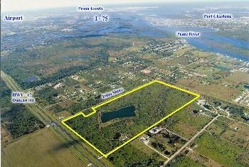
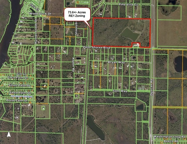
1401 Duncan Rd
402312451001
12-40-23 P-12 73.60 AC M/L S1/2 OF SE1/4 LESS THE E/LY 53.15 FT FURTHER LESS: COMM AT SE COR SEC 12 TH W 87.49 FT TO W ROW US 17 TH CONT W 459.89 FT FOR POB TH N 233.40 FT W 373.26 FT S 233.40 FT E 373.26 FT TO POB RP06211256891 179/561 181/60 E71
Pasture
Charlotte
RE1
Florida
B and X Area of moderate flood hazard, usually the area between the limits of the 100-year and 500-year floods.
73.60 AC
2025
Charlotte County
2025
Southwest Florida
010200
Punta Gorda, FL
8,823 SF
NEARBY LISTINGS FOR SALE OR LEASE
DEMOGRAPHICS near 1401 Duncan Rd
1 mile
3 mile
5 mile
2025 Total Population
927
7,848
28,344
2030 Population
1,031
8,711
31,242
Pop Growth 2025-2030
+ 11.22%
+ 11.00%
+ 10.22%
Average Age
51
51
51
2025 Total Households
428
3,485
12,712
HH Growth 2025-2030
+ 10.98%
+ 11.10%
+ 10.24%
Median Household Inc
$56,176
$66,981
$66,285
Avg Household Size
2.10
2.20
2.20
2025 Avg HH Vehicles
3.00
2.00
2.00
Median Home Value
$311,932
$350,623
$342,787
Median Year Built
1984
1995
1995
Nearby Places
Map Layers
Map Styles
 Street
 Aerial
Layers
 Traffic
 Biking
Places
Listings with unknown addresses are not visible on the map
- Restaurants
- Banks
- Shops
- Fitness
- Groceries
PUBLIC TRANSPORTATION
AIRPORT
Punta Gorda
Drive
Walk
Distance
Punta Gorda
15 min
9.0 mi
Freight Ports
Port Manatee
Drive
Walk
Distance
Port Manatee
92 min
77.3 mi
SALE & LEASE HISTORY
LISTING DATE
SALE/LEASE

Oct 06, 2016
For Sale
Nearby Properties
Address
Land Use
TOTAL SIZE
Lot Size
Zoning
Address
Land Use
TOTAL SIZE
Lot Size
Zoning
1,225,024 SF
170.84 AC
IL
Address
Land Use
TOTAL SIZE
Lot Size
Zoning
2,148 SF
121.95 AC
PD
Address
Land Use
TOTAL SIZE
Lot Size
Zoning
1,556 SF
23.08 AC
CG
Address
Land Use
TOTAL SIZE
Lot Size
Zoning
15,866 SF
63.03 AC
TTRVC
Address
Land Use
TOTAL SIZE
Lot Size
Zoning
31,194 SF
7.93 AC
CG
Address
Land Use
TOTAL SIZE
Lot Size
Zoning
432 SF
20 AC
A-5
Address
Land Use
TOTAL SIZE
Lot Size
Zoning
24,234 SF
3.25 AC
CG
Address
Land Use
TOTAL SIZE
Lot Size
Zoning
21,609 SF
20 AC
AG
Address
Land Use
TOTAL SIZE
Lot Size
Zoning
18,144 SF
2.73 AC
IG
Address
Land Use
TOTAL SIZE
Lot Size
Zoning
4,926 SF
8.10 AC
PKR
Address
Land Use
TOTAL SIZE
Lot Size
Zoning
10,972 SF
1.40 AC
RMF15
Address
Land Use
TOTAL SIZE
Lot Size
Zoning
10,500 SF
3.43 AC
CG
Address
Land Use
TOTAL SIZE
Lot Size
Zoning
5,400 SF
7.09 AC
CG
Address
Land Use
TOTAL SIZE
Lot Size
Zoning
6,109 SF
2 AC
RE1
Address
Land Use
TOTAL SIZE
Lot Size
Zoning
9,219 SF
1.15 AC
CG
Address
Land Use
TOTAL SIZE
Lot Size
Zoning
14.03 AC
CG
Address
Land Use
TOTAL SIZE
Lot Size
Zoning
139.33 AC
ES
Address
Land Use
TOTAL SIZE
Lot Size
Zoning
1,824 SF
17.98 AC
CG
Address
Land Use
TOTAL SIZE
Lot Size
Zoning
840 SF
7.62 AC
CG
Address
Land Use
TOTAL SIZE
Lot Size
Zoning
2,792 SF
9.60 AC
AG
Address
Land Use
TOTAL SIZE
Lot Size
Zoning
7,079 SF
2.27 AC
RMF5
Address
Land Use
TOTAL SIZE
Lot Size
Zoning
3,462 SF
1.83 AC
IL
Address
Land Use
TOTAL SIZE
Lot Size
Zoning
3,087 SF
1.03 AC
CG
Address
Land Use
TOTAL SIZE
Lot Size
Zoning
4,978 SF
0.57 AC
CG
Address
Land Use
TOTAL SIZE
Lot Size
Zoning
8,620 SF
21.60 AC
AG
Address
Land Use
TOTAL SIZE
Lot Size
Zoning
5,000 SF
0.86 AC
CG
Address
Land Use
TOTAL SIZE
Lot Size
Zoning
700 SF
0.88 AC
CG
Address
Land Use
TOTAL SIZE
Lot Size
Zoning
6.84 AC
CG
Address
Land Use
TOTAL SIZE
Lot Size
Zoning
117.80 AC
AG
The World's #1 Commercial Real Estate Marketplace
Connect with us
© 2026 CoStar Group
The information above has been obtained from sources believed reliable. While we do not doubt its accuracy we have not verified it and make no guarantee, warranty or representation about it. It is your responsibility to independently confirm its accuracy and completeness. Any projections, opinions, assumptions, or estimates used are for example only and do not represent the current or future performance of the property. The value of this transaction to you depends on tax and other factors which should be evaluated by your tax, financial, and legal advisors. You and your advisors should conduct a careful, independent investigation of the property to determine to your satisfaction the suitability of the property for your needs.