Property Record
1401 E 29Th St, Muncie, IN 47302
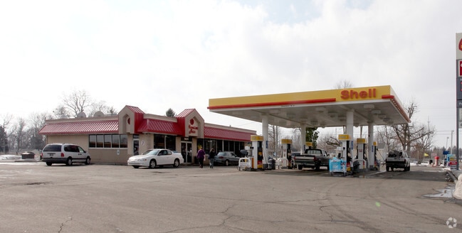

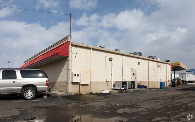

Property Detail
1401 E 29Th St
18-11-27-276-002.000-003
PT E HLF NE QTR 1.494ACRES STR: 272010 IN: OUT:
Conveniencestore
Delaware
B and X Area of moderate flood hazard, usually the area between the limits of the 100-year and 500-year floods.
Indiana
2025
1.49 AC
2025
Muncie/Delaware County
002100
Indianapolis
3,564 SF
Muncie, IN
NEARBY LISTINGS FOR SALE OR LEASE
DEMOGRAPHICS near 1401 E 29Th St
1 mile
3 mile
5 mile
2025 Total Population
4,454
32,332
76,957
2030 Population
4,316
33,359
79,536
Pop Growth 2025-2030
(3.10%)
+ 3.18%
+ 3.35%
Average Age
43
39
37
2025 Total Households
1,961
14,058
31,141
HH Growth 2025-2030
(3.06%)
+ 3.19%
+ 3.46%
Median Household Inc
$56,045
$43,978
$45,907
Avg Household Size
2.20
2.20
2.20
2025 Avg HH Vehicles
2.00
2.00
2.00
Median Home Value
$69,319
$68,800
$107,545
Median Year Built
1954
1954
1964
Nearby Places
Map Layers
Map Styles
 Street
 Aerial
Layers
 Traffic
 Biking
Places
Listings with unknown addresses are not visible on the map
- Restaurants
- Banks
- Shops
- Fitness
- Groceries
Nearby Properties
Address
Land Use
TOTAL SIZE
Lot Size
Zoning
Address
Land Use
TOTAL SIZE
Lot Size
Zoning
73.03 AC
Address
Land Use
TOTAL SIZE
Lot Size
Zoning
1,418 SF
0.91 AC
Address
Land Use
TOTAL SIZE
Lot Size
Zoning
203,080 SF
29.19 AC
Address
Land Use
TOTAL SIZE
Lot Size
Zoning
699,468 SF
14.73 AC
Address
Land Use
TOTAL SIZE
Lot Size
Zoning
Address
Land Use
TOTAL SIZE
Lot Size
Zoning
40,698 SF
0.99 AC
Address
Land Use
TOTAL SIZE
Lot Size
Zoning
216,000 SF
14.23 AC
Address
Land Use
TOTAL SIZE
Lot Size
Zoning
54,192 SF
26.57 AC
Address
Land Use
TOTAL SIZE
Lot Size
Zoning
91,000 SF
10.58 AC
Address
Land Use
TOTAL SIZE
Lot Size
Zoning
151,672 SF
42.83 AC
Address
Land Use
TOTAL SIZE
Lot Size
Zoning
200,000 SF
34.26 AC
Address
Land Use
TOTAL SIZE
Lot Size
Zoning
138,880 SF
0.70 AC
Address
Land Use
TOTAL SIZE
Lot Size
Zoning
122,945 SF
1.64 AC
Address
Land Use
TOTAL SIZE
Lot Size
Zoning
99,000 SF
18 AC
Address
Land Use
TOTAL SIZE
Lot Size
Zoning
14,713 SF
0.19 AC
Address
Land Use
TOTAL SIZE
Lot Size
Zoning
82,980 SF
1.82 AC
Address
Land Use
TOTAL SIZE
Lot Size
Zoning
43,139 SF
1.02 AC
Address
Land Use
TOTAL SIZE
Lot Size
Zoning
82,092 SF
0.75 AC
Address
Land Use
TOTAL SIZE
Lot Size
Zoning
117,000 SF
1.36 AC
Address
Land Use
TOTAL SIZE
Lot Size
Zoning
24,912 SF
1.90 AC
Address
Land Use
TOTAL SIZE
Lot Size
Zoning
24,038 SF
127.98 AC
Address
Land Use
TOTAL SIZE
Lot Size
Zoning
36,018 SF
1.06 AC
Address
Land Use
TOTAL SIZE
Lot Size
Zoning
62,292 SF
8.89 AC
Address
Land Use
TOTAL SIZE
Lot Size
Zoning
78,314 SF
16.53 AC
Address
Land Use
TOTAL SIZE
Lot Size
Zoning
15,144 SF
7.49 AC
Address
Land Use
TOTAL SIZE
Lot Size
Zoning
21,270 SF
0.89 AC
Address
Land Use
TOTAL SIZE
Lot Size
Zoning
62,020 SF
0.48 AC
Address
Land Use
TOTAL SIZE
Lot Size
Zoning
98,400 SF
9.78 AC
Address
Land Use
TOTAL SIZE
Lot Size
Zoning
39,080 SF
0.25 AC
Address
Land Use
TOTAL SIZE
Lot Size
Zoning
71,290 SF
5.47 AC
The World's #1 Commercial Real Estate Marketplace
Connect with us
© 2026 CoStar Group
The information above has been obtained from sources believed reliable. While we do not doubt its accuracy we have not verified it and make no guarantee, warranty or representation about it. It is your responsibility to independently confirm its accuracy and completeness. Any projections, opinions, assumptions, or estimates used are for example only and do not represent the current or future performance of the property. The value of this transaction to you depends on tax and other factors which should be evaluated by your tax, financial, and legal advisors. You and your advisors should conduct a careful, independent investigation of the property to determine to your satisfaction the suitability of the property for your needs.