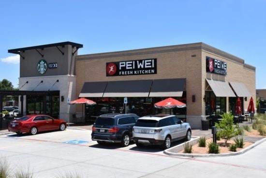
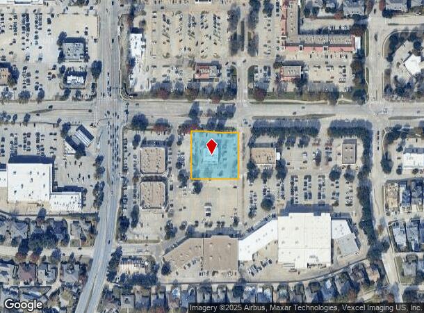
Property Record
1401 E Campbell Rd, Richardson, TX 75081
NEARBY LISTINGS FOR SALE OR LEASE
Property Detail
1401 E Campbell Rd
Dallas-Fort Worth-Arlington, TX
Pavillion East
421296300A0020000
PAVILLION EAST BLK A LT 2 ACS 1.1441 VOL2001026/06945 DD01312001 CO-DC 1296100100200 2CR12961001
Stripcommercialcenter
Dallas
X
Texas
48085C0482K
2
2024
1.14 AC
2025
Richardson
019036
Dallas/Ft Worth
4,859 SF
DEMOGRAPHICS near 1401 E Campbell Rd
1 Mile
3 Mile
5 Mile
2024 Total Population
20,891
133,932
378,395
2029 Population
22,093
143,494
412,812
Pop Growth 2024-2029
+ 5.75%
+ 7.14%
+ 9.10%
Average Age
34
38
39
2024 Total Households
7,209
54,422
166,016
HH Growth 2024-2029
+ 8.49%
+ 8.37%
+ 9.58%
Median Household Inc
$59,651
$74,416
$73,248
Avg Household Size
2.30
2.30
2.20
2024 Avg HH Vehicles
2.00
2.00
2.00
Median Home Value
$425,616
$420,434
$388,688
Median Year Built
1978
1979
1985
Nearby Places
Map Layers
Map Styles
 Street
 Aerial
- Restaurants
- Banks
- Shops
- Fitness
- Groceries
PUBLIC TRANSPORTATION
AIRPORT
Dallas Love Field
DRIVE
WALK
Distance
Dallas Love Field
25 min
15.7 mi
Dallas-Fort Worth International
DRIVE
WALK
Distance
Dallas-Fort Worth International
32 min
25.2 mi
Freight Ports
Port of Shreveport
DRIVE
WALK
Distance
Port of Shreveport
222 min
202.8 mi
Nearby Properties
Address
Land Use
TOTAL SIZE
Lot Size
Zoning
Address
Land Use
TOTAL SIZE
Lot Size
Zoning
1,614,550 SF
77.76 AC
SFR
Address
Land Use
TOTAL SIZE
Lot Size
Zoning
492,661 SF
4.89 AC
Address
Land Use
TOTAL SIZE
Lot Size
Zoning
343,539 SF
34.74 AC
S-164
Address
Land Use
TOTAL SIZE
Lot Size
Zoning
686,032 SF
9 AC
R2000
Address
Land Use
TOTAL SIZE
Lot Size
Zoning
369,694 SF
Address
Land Use
TOTAL SIZE
Lot Size
Zoning
533,962 SF
29.78 AC
MF-M
Address
Land Use
TOTAL SIZE
Lot Size
Zoning
445,071 SF
107.94 AC
2493-A TO-
Address
Land Use
TOTAL SIZE
Lot Size
Zoning
430,618 SF
11.33 AC
MF-H
Address
Land Use
TOTAL SIZE
Lot Size
Zoning
394,287 SF
14.96 AC
Address
Land Use
TOTAL SIZE
Lot Size
Zoning
507,693 SF
32.50 AC
MFL
Address
Land Use
TOTAL SIZE
Lot Size
Zoning
520,713 SF
8.03 AC
Address
Land Use
TOTAL SIZE
Lot Size
Zoning
393,416 SF
Address
Land Use
TOTAL SIZE
Lot Size
Zoning
706,061 SF
36.76 AC
Z109
Address
Land Use
TOTAL SIZE
Lot Size
Zoning
451,672 SF
23.81 AC
LI-1
Address
Land Use
TOTAL SIZE
Lot Size
Zoning
289,093 SF
8.87 AC
R/O-2
Address
Land Use
TOTAL SIZE
Lot Size
Zoning
386,448 SF
Address
Land Use
TOTAL SIZE
Lot Size
Zoning
421,532 SF
4.29 AC
Address
Land Use
TOTAL SIZE
Lot Size
Zoning
537,928 SF
11.13 AC
Z109
Address
Land Use
TOTAL SIZE
Lot Size
Zoning
488,063 SF
31.19 AC
MF-L
Address
Land Use
TOTAL SIZE
Lot Size
Zoning
260,608 SF
18.68 AC
COMM
Address
Land Use
TOTAL SIZE
Lot Size
Zoning
211,607 SF
Address
Land Use
TOTAL SIZE
Lot Size
Zoning
387,098 SF
18.40 AC
MF-29
Address
Land Use
TOTAL SIZE
Lot Size
Zoning
302,594 SF
16.02 AC
TO-M
Address
Land Use
TOTAL SIZE
Lot Size
Zoning
299,130 SF
14.73 AC
R/O-M
Address
Land Use
TOTAL SIZE
Lot Size
Zoning
282,695 SF
3.32 AC
Address
Land Use
TOTAL SIZE
Lot Size
Zoning
340,812 SF
5.34 AC
R/0-M
Address
Land Use
TOTAL SIZE
Lot Size
Zoning
280,098 SF
3.32 AC
Address
Land Use
TOTAL SIZE
Lot Size
Zoning
414,806 SF
64.41 AC
LI-1
Address
Land Use
TOTAL SIZE
Lot Size
Zoning
470,129 SF
4.43 AC
Z112
The World's #1 Commercial Real Estate Marketplace
Connect with us
© 2025 CoStar Group
The information above has been obtained from sources believed reliable. While we do not doubt its accuracy we have not verified it and make no guarantee, warranty or representation about it. It is your responsibility to independently confirm its accuracy and completeness. Any projections, opinions, assumptions, or estimates used are for example only and do not represent the current or future performance of the property. The value of this transaction to you depends on tax and other factors which should be evaluated by your tax, financial, and legal advisors. You and your advisors should conduct a careful, independent investigation of the property to determine to your satisfaction the suitability of the property for your needs.