Property Record
1401 E Main St, Carbondale, IL 62901
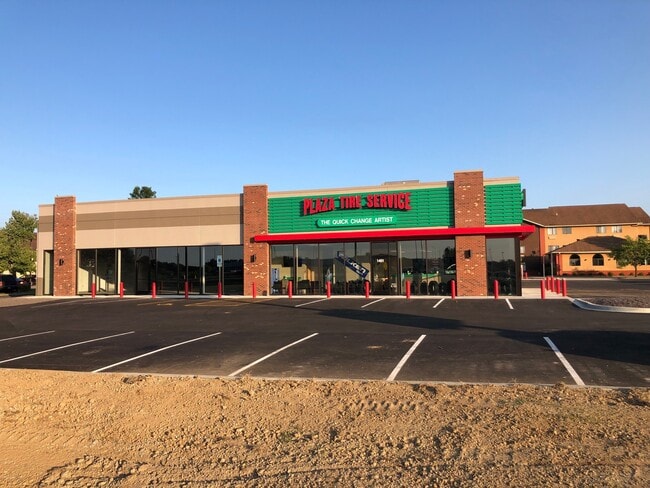

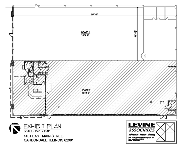

Current Lease Availabilities
Property Detail
1401 E Main St
Carbondale, IL
LOT 1 QUALLS SUB 14-9-1 974/86 2021R005047 PIER 1 IMPORT
15-14-326-007
Jackson
Commercialnec
Illinois
AE The base floodplain where base flood elevations are provided. AE Zones are now used on new format FIRMs instead of A1-A30 Zones.
1
2024
1.29 AC
2024
Marion/I-64 & South
011200
Other Market Areas
15,200 SF
NEARBY LISTINGS FOR SALE OR LEASE
DEMOGRAPHICS near 1401 E Main St
1 mile
3 mile
5 mile
2025 Total Population
689
19,159
32,020
2030 Population
675
19,367
32,381
Pop Growth 2025-2030
(2.03%)
+ 1.09%
+ 1.13%
Average Age
34
33
36
2025 Total Households
342
8,806
14,057
HH Growth 2025-2030
(2.05%)
+ 1.14%
+ 1.12%
Median Household Inc
$36,358
$31,180
$38,973
Avg Household Size
2.00
1.90
2.00
2025 Avg HH Vehicles
1.00
1.00
2.00
Median Home Value
$103,846
$122,594
$164,049
Median Year Built
1971
1976
1980
Nearby Places
Map Layers
Map Styles
 Street
 Aerial
Layers
 Traffic
 Biking
Places
Listings with unknown addresses are not visible on the map
- Restaurants
- Banks
- Shops
- Fitness
- Groceries
PUBLIC TRANSPORTATION
COMMUTER RAIL
Drive
Walk
Distance
6 min
2.8 mi
Nearby Properties
Address
Land Use
TOTAL SIZE
Lot Size
Zoning
Address
Land Use
TOTAL SIZE
Lot Size
Zoning
Address
Land Use
TOTAL SIZE
Lot Size
Zoning
16.78 AC
Address
Land Use
TOTAL SIZE
Lot Size
Zoning
9,360 SF
1.56 AC
Address
Land Use
TOTAL SIZE
Lot Size
Zoning
84,270 SF
6.50 AC
Address
Land Use
TOTAL SIZE
Lot Size
Zoning
17,700 SF
18.37 AC
Address
Land Use
TOTAL SIZE
Lot Size
Zoning
17.78 AC
Address
Land Use
TOTAL SIZE
Lot Size
Zoning
17,820 SF
9 AC
Address
Land Use
TOTAL SIZE
Lot Size
Zoning
6,750 SF
4.53 AC
Address
Land Use
TOTAL SIZE
Lot Size
Zoning
24,936 SF
3.76 AC
Address
Land Use
TOTAL SIZE
Lot Size
Zoning
8.67 AC
Address
Land Use
TOTAL SIZE
Lot Size
Zoning
119,175 SF
2.84 AC
Address
Land Use
TOTAL SIZE
Lot Size
Zoning
18.41 AC
Address
Land Use
TOTAL SIZE
Lot Size
Zoning
79,800 SF
2.50 AC
Address
Land Use
TOTAL SIZE
Lot Size
Zoning
10.15 AC
Address
Land Use
TOTAL SIZE
Lot Size
Zoning
Address
Land Use
TOTAL SIZE
Lot Size
Zoning
13,440 SF
0.83 AC
Address
Land Use
TOTAL SIZE
Lot Size
Zoning
1.21 AC
Address
Land Use
TOTAL SIZE
Lot Size
Zoning
14,040 SF
2.37 AC
Address
Land Use
TOTAL SIZE
Lot Size
Zoning
88,081 SF
11.29 AC
Address
Land Use
TOTAL SIZE
Lot Size
Zoning
61,600 SF
6.99 AC
Address
Land Use
TOTAL SIZE
Lot Size
Zoning
3.88 AC
Address
Land Use
TOTAL SIZE
Lot Size
Zoning
3,072 SF
1.89 AC
Address
Land Use
TOTAL SIZE
Lot Size
Zoning
0.85 AC
Address
Land Use
TOTAL SIZE
Lot Size
Zoning
84,810 SF
7.50 AC
Address
Land Use
TOTAL SIZE
Lot Size
Zoning
63,000 SF
2.62 AC
Address
Land Use
TOTAL SIZE
Lot Size
Zoning
1.64 AC
Address
Land Use
TOTAL SIZE
Lot Size
Zoning
2,800 SF
3.58 AC
The World's #1 Commercial Real Estate Marketplace
Connect with us
© 2026 CoStar Group
The information above has been obtained from sources believed reliable. While we do not doubt its accuracy we have not verified it and make no guarantee, warranty or representation about it. It is your responsibility to independently confirm its accuracy and completeness. Any projections, opinions, assumptions, or estimates used are for example only and do not represent the current or future performance of the property. The value of this transaction to you depends on tax and other factors which should be evaluated by your tax, financial, and legal advisors. You and your advisors should conduct a careful, independent investigation of the property to determine to your satisfaction the suitability of the property for your needs.